Biogeochemical and Geohydrologic Processes in
a Landfill-Impacted Alluvial
Aquifer, Norman, Oklahoma
Introduction

Project Overview
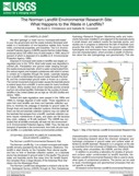
The Norman Landfill is a closed municipal landfill
located on alluvium associated with the Canadian River in central Oklahoma.
The U.S. Geological Survey began a multi-disciplinary investigation in 1994 at the
Norman Landfill, as part of the Toxic Substances Hydrology Program, in
collaboration with scientists at the University of Oklahoma, Oklahoma State
University, and the Environmental Protection Agency. The contamination of the
shallow alluvial aquifer at the Norman Landfill provides an excellent
opportunity to study the spatial variability of biogeochemical processes and the
resulting effects on the fate of degradable contaminants in the leachate plume.
The emphasis of this multi-disciplinary research project is on developing a
unified understanding of the processes controlling contaminant distribution and
migration. The vast number of landfill sites and ubiquitous nature of alluvial
deposits will make the results of this study highly transferable.
The Research Site
The landfill accepted solid waste from 1922 to 1985, when it was
closed, covered with a clay cap, and vegetated. The landfill was
estimated to have received about 1,128 tons of municipal waste per
week in 1982. The landfill is excavated in alluvium adjacent to the
Canadian River. The alluvium ranges in thickness from 10 to 15 meters
and consists of lenticular beds of unconsolidated clay, silt, sand,
and gravel. Depth to water is shallow, ranging from land surface to
about 4 meters. Beneath the alluvium is a confining unit, the
Hennessey Group, consisting of reddish-brown shales and mudstones,
with a few thin beds of very fine-grained sandstone.
Flow System
Depth to ground water was measured in the Canadian River alluvium in
the winter of 1995-96 to construct a potentiometric-surface map (Scholl and Christenson, 1998). The
winter was chosen to minimize the effects of transpiration of water by
plants at the site, many of which have root systems that extend to the
water table. A network of shallow, small diameter, temporary wells was
constructed to measure depth to water. The wells consisted of
2.64-centimeter inside-diameter, schedule-40 stainless steel line pipe,
with threaded couplings, attached to stainless steel screened
sandpoints with a screen length of 0.76 meter. The wells were driven using
an electric jack hammer until the well screen was just below the water
table. The elevations of the wells were determined using
dual-frequency, carrier-phase global positioning system (GPS)
receivers and depth to water was determined by lowering a steel tape
into the well and noting the water mark. The potentiometric surface
in the Canadian River alluvium near the Norman Landfill was a
relatively simple surface during the winter of 1995-96. The surface
slopes toward the Canadian River, indicating that ground water is
moving through the alluvium toward the River. The hydraulic gradient
was approximately 2.8 meters/kilometer north of the Norman Landfill
and 1.4 meters/kilometer south of the Landfill.
Extent of the Plume
Geophysical electromagnetic induction surveys were performed on the alluvial
plain surrounding the Norman Landfill in January and February 1995 (Lucius and Bisdorf, 1995; Bisdorf, 1996). The
purpose of these surveys was to determine the vertical and horizontal extent
of the leachate plume. Electromagnetic Induction Surveys measure the
electrical conductivity of the aquifer materials, both soils and fluids.
The surveys show higher conductivity south of the landfill, which is
consistent with hydraulic and geochemical evidence indicating a leachate
plume has developed and is flowing toward the Canadian River.
Conductivity measurements and dissolved organic carbon analyses confirm that
the plume has migrated beneath the slough and extends through the entire
thickness of the alluvium.
Quick Facts: Why is the Norman Landfill Research Site Valuable?
-
The Norman Landfill Research Site was selected in 1994 because it is an unlined landfill that is typical of hundreds of thousands of closed landfills across the United States. Research from this site is being used to gain greater understanding of natural biodegradation and migration of contaminants from a typical landfill, providing cities across the Nation better scientific basis for planning remedial activities on closed landfill sites.
-
The Norman Landfill Research Site is a world-class natural laboratory. There are only four long-term hydro-bio-geochemical studies of subsurface systems in the world. This is the only such site in the U.S., with research having been conducted at this site for more than 30 years. More than 1,300 monitoring wells and sampling devices have been installed at this site. Research at the Norman Landfill has led to greater understanding of how landfills interact with the surrounding environment and the important role of natural biodegradation processes in minimizing the effects of landfills on the environment.
-
Research at the Norman Landfill has led to advances in technology with widespread applications, including high-resolution geophysics, new methods of water-quality monitoring, the existence of emerging contaminants in ground and surface water, and advances in methods used to measure water cycling in the environment.
-
More than 150 articles have been published about research at the landfill site, producing benefits for many cities with closed landfills across the Nation and the world. Nine Ph.D. dissertations and 11 Master’s theses have been completed at the site. The site has been used for training local high school teachers through the Oklahoma Science Project and undergraduate students through the National Science Foundation’s Research Experience for Undergraduates Program
-
Federal, state, and private sources have provided approximately $15 million in grants at the site. Funds spent on salaries of local researchers, as well as locally for lodging and purchases of supplies and equipment comprise about 25 percent of that funding. Grants are in place from the National Science Foundation, U.S. Department of Energy, and the USGS Toxic Substances Hydrology Program for approximately $5 million—an expression in confidence in the value of research being conducted at the site and the usefulness of the site as a test bed for development of new technologies.
-
Research at the landfill has pinpointed small areas of environmental impact of the landfill. Preventing or minimizing the scope of long-term monitoring and cleanup at the Norman landfill is likely to save millions of dollars in municipal funds over a decade or more.
-
Many students and faculty from Oklahoma high schools and Universities across the Nation have utilized the landfill site as a natural environmental classroom in the fields of hydrology, geochemistry, geomorphology, geophysics, microbiology and ecology.
Research Partners
- U.S. Geological Survey
- U.S. Environmental Protection Agency
- The City of Norman
- The University of Oklahoma
- Oklahoma State University
- Texas A&M University
- Colorado School of Mines
- The University of Tulsa
- Oregon State University
- Michigan State University
Featured Publications
| 
View sequence as animation |


