
USGS/Cascades Volcano Observatory, Vancouver, Washington
Oregon Volcanoes and Volcanics
Maps and Graphics, etc.
-
 [Interactive Imagemap]
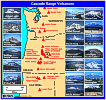
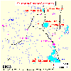
Cascade Range Volcanoes
-- Graphic by: Lyn Topinka, 1996
-
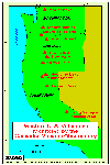
 [Map,16K,InlineGIF]
Location of the Cascade Range Volcanoes
-- Modified from: Tilling, et.al., 1990
-
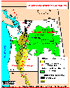
 [Map,27K,InlineGIF]
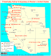
Potentially Active Volcanoes of the Western United States
-- Modified from: Brantley, 1994, Volcanoes of the United States:
USGS General Interest Publication
-
 [Map,20K,InlineGIF]
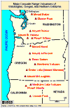
Major West Coast Volcanoes - Washington, Oregon, and California
-
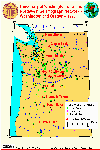
 [Map,21K,GIF]
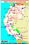
Map of Western United States, showing locations of volcanoes
monitored by CVO
-- Mount Baker to Long Valley
-- Modified from: Iwatsubo and Swanson, 1992,
IN: USGS Bulletin 1966
-
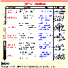
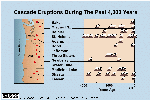 [Graphic,70K,InlineGIF]
Cascades Eruptions During the Past 4000 Years
-
 [Map,35K,InlineGIF]
Pacific Northwest Volcanics showing the Cascade Range and
Columbia Plateau
-- Modified from: Swanson et.al., 1989,
American Geophysical Union Field Trip Guidebook T106
-
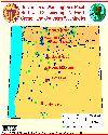
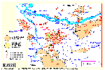
 [Map,40K,InlineGIF]
University of Washington's Pacific Northwest Seismic Network
-- Modified from: University of Washington Geophysics Program, 1998,
includes seismic station location map and link to PNSN
-
 [Map,30K,InlineGIF]
Oregon and Southern Washington -
University of Washington's Pacific Northwest Seismograph Network
-- Modified from: University of Washington Geophysics Program, 1999,
includes seismic station location map and link to PNSN
-
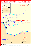 [Map,20K,InlineGIF]
Southwest Washington - Northwest Oregon
-- includes Mounts Rainier, St. Helens, Adams, and Hood
-- Modified from: Doukas, 1990, USGS Bulletin 1859
-
 [Map,17K,InlineGIF]
Bend/Sisters/Santiam Pass/McKenzie Pass Area
-- Modified from: Taylor, Oregon State University, 1981,
USGS Circular 838
-
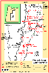 [Map,25K,InlineGIF]
Central Oregon High Cascades
-- Modified from: Scott and Gardner, 1990
-
 [Map,23K,InlineGIF]
Southern Oregon Cascades
-- Modified from: Hoblitt, et.al., 1987, USGS Open-File Report 87-297
-
 [Graphic,36K,InlineGIF]
Different volcano types in the Portland area
-- Modified from: Allen, 1975, The Ore-Bin no.37, no.9
-
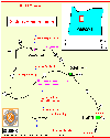
 [Map,35K,InlineGIF]
Location and elevation of 95 vents, including multiple vents,
in the Portland area
-- Modified from: Allen, 1975, The Ore-Bin no.37, no.9
-
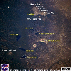
 [Image,96K,InlineJPG]
Annotated NASA Image:
Looking South at the
Three Sisters, Mount Jefferson, and Mount Hood, Oregon, August 1985.
-- NASA Photo, courtesy
NASA Earth From Space;
Modified with text by USGS/CVO.
-
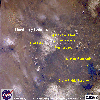
 [Image,129K,InlineJPG]
Annotated NASA Image:
Three Sisters, Broken Top, Mount Bachelor, and Diamond Peak, October 1994.
-- NASA Photo, courtesy
NASA Earth From Space;
Modified with text by USGS/CVO.
-
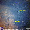
 [Image,86K,InlineJPG]
Annotated NASA Image:
Snow-clad Newberry Caldera, Oregon, May 1985.
-- NASA Photo, courtesy
NASA Earth From Space;
Modified with text by USGS/CVO.
Return to:
[Oregon Volcanoes and Volcanics Menu]
[MORE Cascade Range Maps and Graphics]
[Mount Bachelor Maps and Graphics]
[Columbia Plateau Maps and Graphics]
[Crater Lake Maps and Graphics]
[Mount Hood Maps and Graphics]
[Mount Jefferson Maps and Graphics]
[Newberry Caldera Maps and Graphics]
[Three-Fingered Jack Maps and Graphics]
[Three Sisters Maps and Graphics]

Use of CVO Material and Copyright Information
URL for CVO HomePage is:
<http://vulcan.wr.usgs.gov/home.html>
URL for this page is:
<http://vulcan.wr.usgs.gov/Volcanoes/Oregon/Graphics/framework.html>
If you have questions or comments please contact:
<GS-CVO-WEB@usgs.gov>
09/02/08, Lyn Topinka
 [Map,21K,GIF]