
USGS/Cascades Volcano Observatory, Vancouver, Washington
Ash and Tephra
Maps and Graphics, etc.
-
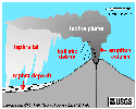 [Graphic,12K,GIF]
Schematic drawing of erupting volcano showing tephra types
-- Modified from:
Gardner, et.al., 1995, USGS Open-File Report 95-498
-
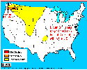 [Map,14K,InlineGIF]
Distribution within the United States of
May 18, 1980 ash fallout from Mount St. Helens
-- Modified from: Tilling, Topinka, and Swanson, 1990
-
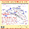 [Map,22K,InlineGIF]
May 18, 1980 Ash Plume Path
-- Modified from: Sarna-Wojcicki, et.al., 1981, IN:
USGS Professional Paper 1250
-
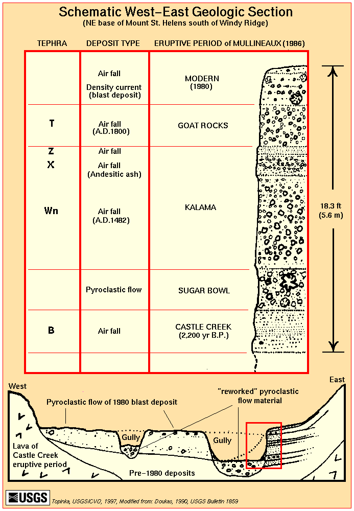
 [Schematic,25K,GIF]
West-East Geologic Section of gully bank near NE base of
Mount St. Helens, south of Windy Ridge
-- Modified from: Doukas, 1990, USGS Bulletin 1859
-
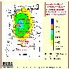 [Map,14K,InlineGIF]
Annual probablility of 10 centimeters or more of tephra accumulation in
Washington and Oregon from major Cascade volcanoes
-- Modified from:
Scott, et.al., 1995, USGS Open-File Report 95-492
-
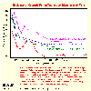 [Graphic,18K,InlineGIF]
Plot of thickness vs. distance from vent for several tephras from
Cascade Range volcanoes.
-- Modified from:
Hoblitt, et.al., 1987, USGS Open-File Report 87-297
-
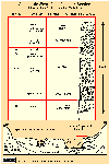
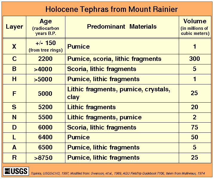
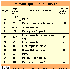 [Table,14K,GIF]
Holocene tephras from Mount Rainier
-- Modified from: Swanson, et.al., 1989, AGU Field Trip Guidebook T106,
Taken from; Mullineaux, 1974
-
 [TableHTML]
Source, age, and description of some postglacial pyroclastic deposits in
Mount Rainier National Park
-- Modified from: Crandell, 1971, USGS Professional Paper 677
-
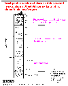 [Graphic,12K,GIF]
Stratigraphic section of Mazama ash
exposed in excavation at West Village parking lot,
at Mount Bachelor.
Letter and number symbols to right of column are horizon
designations of surface and buried soils.
-- Modified from: Scott and Gardner, 1990
Return to:
[Ash and Tephra Menu] ...

URL for CVO HomePage is:
<http://vulcan.wr.usgs.gov/home.html>
URL for this page is:
<http://vulcan.wr.usgs.gov/Glossary/Tephra/Graphics/framework.html>
If you have questions or comments please contact:
<GS-CVO-WEB@usgs.gov>
09/02/08, Lyn Topinka
 [Graphic,12K,GIF]
 [Schematic,25K,GIF]
 [Table,14K,GIF]
 [Graphic,12K,GIF]