
USGS/Cascades Volcano Observatory, Vancouver, Washington
CVO Photo Archives
Annotated NASA Images
-
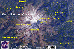 [Image,80K,InlineJPG]
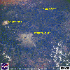
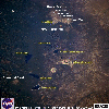
Mount Rainier, Washington, September 1994.
-- NASA Photo, courtesy NASA Earth From Space;
Modified with text by USGS/CVO.
-
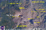
 [Image,86K,InlineJPG]
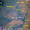
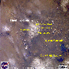
Mount St. Helens and Vicinity, Washington, September 1992.
-- NASA Photo, courtesy NASA Earth From Space;
Modified with text by USGS/CVO.
-
 [Image,99K,InlineJPG]
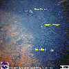
Mount St. Helens, Washington, September 1994.
-- NASA Photo, courtesy NASA Earth From Space;
Modified with text by USGS/CVO.
-
 [Image,168K,InlineJPG]
Looking North-Northeast across the Columbia River to Mount St. Helens, October 1994.
-- NASA Photo, courtesy NASA Earth From Space;
Modified with text by USGS/CVO.
-
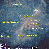
 [Image,106K,InlineJPG]
Looking South at
Mount Adams, Mount St. Helens, and the Columbia River, Washington, August 1989.
-- NASA Photo, courtesy NASA Earth From Space;
Modified with text by USGS/CVO.
-
 [Image,97K,InlineJPG]
Looking West at Mount Hood, Oregon, the Columbia River, and Mount St. Helens and Mount Adams, Washington,
September 1994
-- NASA Photo, courtesy NASA Earth From Space;
Modified with text by USGS/CVO.
-
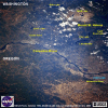
 [Image,110K,InlineJPG]
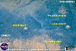
Columbia River and the Columbia Basin, Washington/Oregon, September 1994.
-- NASA Photo, courtesy NASA Earth From Space;
Modified with text by USGS/CVO.
-
 [Image,96K,InlineJPG]
Looking South at Mount Hood, Mount Jefferson, Three Sisters, and
Broken Top, August 1985.
-- NASA Photo, courtesy NASA Earth From Space;
Modified with text by USGS/CVO.
-
 [Image,129K,InlineJPG]
Three Sisters, Broken Top, Mount Bachelor, and Diamond Peak, Oregon, October 1994.
-- NASA Photo, courtesy NASA Earth From Space;
Modified with text by USGS/CVO.
-
 [Image,86K,InlineJPG]
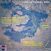
Snow-clad Newberry Caldera, Oregon, May 1985.
-- NASA Photo, courtesy NASA Earth From Space;
Modified with text by USGS/CVO.
-
 [Image,30K,InlineJPG]
Craters of the Moon, Idaho
-- NASA Photo, courtesy NASA Earth From Space;
Modified with text by USGS/CVO.
-
 [Image,84K,InlineJPG]
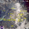
Katmai Vicinity, including the Valley of Ten Thousand Smokes, Alaska,
August 1989.
-- NASA Photo, courtesy NASA Earth From Space;
Modified with text by USGS/CVO.
Return to:
[CVO Photo Archives - NASA Images Menu] ...
[CVO Photo Archives Menu] ...

Use of CVO Material and Copyright Information
URL for CVO HomePage is:
<http://vulcan.wr.usgs.gov/home.html>
URL for this page is:
<http://vulcan.wr.usgs.gov/Photo/NASA/AnnotatedImages/framework.html>
If you have questions or comments please contact:
<GS-CVO-WEB@usgs.gov>
05/22/02, Lyn Topinka
 Use of CVO Material and Copyright Information