USGS/CVO Logo, click to link to National USGS Website
USGS/Cascades Volcano Observatory, Vancouver, Washington

Annotated NASA Images
Newberry Caldera, Oregon


Snow-clad Newberry Caldera, Oregon, May 1985.
-- NASA Photo, courtesy "NASA Earth From Space" Website; Modified with text by USGS/CVO.

STS51B-038-0091 Newberry Volcano, Oregon, U.S.A. May 1985.
Snow-covered Newberry Volcano (center of the photograph) lies 40 miles (64 kilometers) east of the Cascade Mountains. Inside the caldera are two lakes—Paulina and East—separated by lava and obsidian flows and a cinder cone 1 mile (1.6 kilometers) wide and 700 feet (214 meters) high. To the east are the Deschutes River and Wickiup Reservoir.
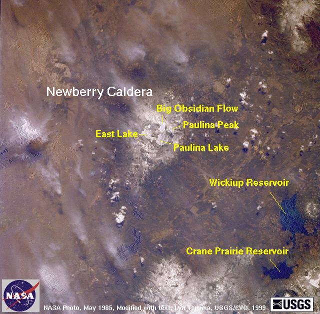

Annotated NASA Image, Newberry, May 1985


Return to:
[CVO Photo Archives - NASA Images Menu] ...
[CVO Photo Archives Menu] ...
[Newberry Caldera Menu] ...
[Oregon Volcanoes and Volcanics Menu] ...


CVO HomePage Volcanoes of the World Menu Mount St. Helens Menu Living With Volcanoes Menu Publications and Reports Menu Volcano Monitoring Menu Servers and Useful Sites Menu Volcano Hazards Menu Research and Projects Menu Educational Outreach Menu Hazards, Features, and Terminology Menu Maps and Graphics Menu CVO Photo Archives Menu Conversion Tables CVO Index - Search Our Site ButtonBar

URL for CVO HomePage is: <http://vulcan.wr.usgs.gov/home.html>
URL for this page is: <http://vulcan.wr.usgs.gov/Photo/NASA/AnnotatedImages/nasa_newberry_8505.html>
If you have questions or comments please contact: <GS-CVO-WEB@usgs.gov>
04/22/08, Lyn Topinka