 Basic Information
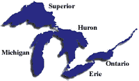
The Great Lakes - Superior, Michigan, Huron, Erie and Ontario - are a dominant part of the physical and cultural heritage of North America. Shared with Canada and spanning more than 750 miles (1,200 kilometers) from west to east, these vast inland freshwater seas have provided water for consumption, transportation, power, recreation and a host of other uses.
The Great Lakes are the largest surface freshwater system on the Earth. They contain about 84 percent of North America's surface fresh water and about 21 percent of the world's supply. Only the polar ice caps contain more fresh water. (For additional information, see Physical Facts.)
Nearly 25 percent of Canadian agricultural production and 7 percent of American farm production are located in the basin. More than 30 million people live in the Great Lakes basin - roughly 10 percent of the U.S. population and more than 30 percent of the Canadian population. The daily activities of these people, from the water consumed to the waste returned, directly affect the Great Lakes environments.
In spite of their large size, the Great Lakes are sensitive to the effects of a wide range of pollutants. Major stresses on the lakes include toxic and nutrient pollution, invasive species and habitat degradation. Sources of pollution include the runoff of soils and farm chemicals from agricultural lands, waste from cities, discharges from industrial areas and leachate from disposal sites. The large surface area of the lakes also makes them vulnerable to direct atmospheric pollutants that fall as rain, snow, or dust on the lake surface, or exchange as gases with the lake water. Outflows from the Great Lakes are relatively small (less than 1 percent per year) in comparison with the total volume of water. Pollutants that enter the lakes are retained in the system and become more concentrated with time. (For additional information, see the Great Lakes Atlas.)
Addressing these problems is complicated by the fact that the Great Lakes Basin encompasses large parts of two nations, the United States and Canada. Within the US, EPA and nine other federal agencies together administer more than 140 different federal programs helping fund and implement environmental restoration and management activities in the Great Lakes basin. In addition, governance of the Great Lakes system is shared with eight U.S. states, nearly 40 Tribal Nations, more than half a dozen major metropolitan areas, and numerous county and local governments.
In May 2004, President Bush signed an Executive Order creating the Great Lakes Interagency Task Force, under the lead of EPA. The Task Force brings together all ten Agency and Cabinet officers to provide strategic direction on federal Great Lakes policy, priorities and programs. In addition, order directs EPA to work with Chairs of the Council of Great Lakes Governors and the Great Lakes Cities Initiative to convene a complementary process of regional collaboration. (Additional information, see Interagency Task Force.)
EPA's work is handled through its Great Lakes National Program Office. The Boundary Waters Treaty of 1909 and the 1987 Great Lakes Water Quality Agreement (GLWQA) with Canada provide the basis for our international efforts to manage this shared resource. The Great Lakes 5-Year Strategy, developed jointly by EPA and its multi-state, multi-Agency partners and built on the foundation of the GLWQA, provides the agenda for Great Lakes ecosystem management, and Lakewide Management Plans have been developed for each lake.
- Lake briefs: short descriptions of each lake
- Physical facts about the lakes: depth, size, shoreline, etc.
- Environmental atlas and resource book: a detailed discussion (available in English and French)
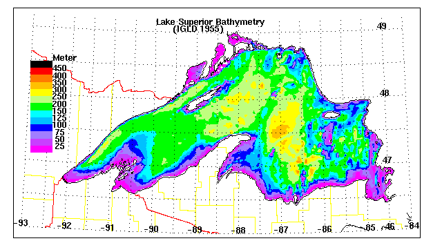
Lake Superior is the largest in terms
of volume. It is also the deepest and coldest of the five. Because
of its size, Superior has a retention time of 191 years. Retention
time is a measure based on the volume of water in the lake and
the mean rate of outflow. Most of the Superior basin is forested,
with little agriculture because of a cool climate and poor soils.
The forests and sparse population result in relatively few pollutants
entering Lake Superior, except through airborne transport [More
information | Lake
Superior bathymetric map ![]() ].
].
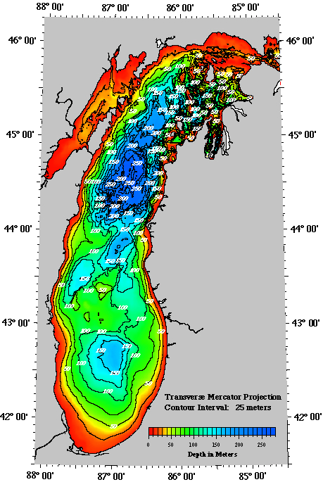
Lake Michigan, the second largest,
is the only Great Lake entirely within the United States. The
northern part is in the colder, less developed upper Great Lakes
region. It is sparsely populated, except for the Fox River Valley,
which drains into Green Bay. This bay has one of the most productive
Great Lakes fisheries but receives the wastes from the world's
largest concentration of pulp and paper mills. The more temperate
southern basin of Lake Michigan is among the most urbanized areas
in the Great Lakes system. It contains the Milwaukee and Chicago
metropolitan areas. This region is home to about 8 million people
or about one-fifth of the total population of the Great Lakes
basin [More
information | Lake
Michigan bathymetric map ![]() ].
].
Lake Huron, which includes Georgian
Bay, is the third largest of the lakes by volume. Many Canadians
and Americans own cottages on the shallow, sandy beaches of Huron
and along the rocky shores of Georgian Bay. The Saginaw River
basin is intensively farmed and contains the Flint and Saginaw-Bay
City metropolitan areas. Saginaw Bay, like Green Bay, contains
a very productive fishery [More
information | Lake
Huron bathymetric map![]() ].
].
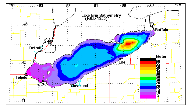
Lake Erie is the smallest of the lakes
in volume and is exposed to the greatest effects from urbanization
and agriculture. Because of the fertile soils surrounding the
lake, the area is intensively farmed. The lake receives runoff
from the agricultural area of southwestern Ontario and parts of
Ohio, Indiana and Michigan. Seventeen metropolitan areas with
populations over 50,000 are located within the Lake Erie basin.
Although the area of the lake is about 26,000 km2 (10,000
square miles), the average depth is only about 19 meters (62 feet).
It is the shallowest of the five lakes and therefore warms rapidly
in the spring and summer, and frequently freezes over in winter.
It also has the shortest retention time of the lakes, 2.6 years.
The western basin, comprising about one-fifth of the lake, is
very shallow with an average depth of 7.4 meters (24 feet) and
a maximum depth of 19 meters (62 feet) [More
information | Lake
Erie bathymetric map![]() ].
].
Lake Ontario, although slightly smaller
in area, is much deeper than its upstream neighbor, Lake Erie,
with an average depth of 86 meters (283 feet) and a retention
time of about 6 years. Major urban industrial centers, such as
Hamilton and Toronto, are located on its shore. The U.S. shore
is less urbanized and is not intensively farmed, except for a
narrow band along the lake [More
information | Lake
Ontario bathymetric map![]() ].
].
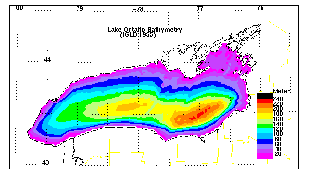
Who is working to protect the Great Lakes?
Within EPA, the Great Lakes National Program Office coordinates efforts. EPA also works with several federal agencies, state governments, Canada, tribes, and other organizations to keep the Great Lakes clean and healthy.
Find specific information on the "interested parties" page.
Great Lakes Legacy Act
The Great Lakes Legacy Act, signed by President George W. Bush in 2002, provides $270 million over five years to clean up contaminated sediments from the Great Lakes and to educate people about this issue. EPA's Great Lakes National Program Office evaluates and funds projects under the Act. Priority is given to projects that are:
- Cleaning up contaminated sediment;
- Identified in a Remedial Action Plan;
- Ready to be implemented;
- Using an innovative approach, technology, or technique that may provide greater environmental benefits, or equivalent environmental benefits at a reduced cost; or
- Include remediation that will start within a year of being
funded.
Learn more about the Legacy Act.