 |
||
|
Strategic Goal 3
Observe, protect, and manage the Earth’s resources to promote environmental stewardship
The Department has responsibilities for the environment, ecosystems, safety, and commerce of the Nation that span oceanic, coastal, and atmospheric domains. Understanding the oceans and atmosphere is essential to sustaining U.S. environmental and economic health. The Department provides products and services that are a critical component of the daily decisions made across the United States. From hurricane tracking to El Niño and harmful algal bloom predictions, navigational charts to fish stock assessments, severe weather forecasts to coastal zone management—the Department’s future-oriented science, service, and stewardship missions touch the life of every citizen in the United States and in much of the world every day. Together the Department and its partners provide weather and climate services; conduct atmospheric, climate, and ecosystems research; manage and protect fisheries and sensitive marine ecosystems; promote efficient and environmentally safe commerce and transportation; and provide emergency response and vital information in support of homeland security. The breadth and scope of these services require the Department to be responsive to both short-term and long-term societal needs. FY 2007 accomplishments include: EUMETSAT Satellite, a Milestone in U.S.-European Cooperation, Sends First Images
|
||||||||||||||||||||||||||||||||||||||||||||||||||||||||||||||||||||||||||||||||||||||||||||||||||||
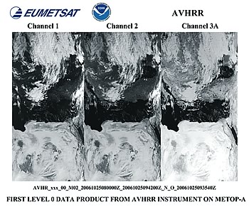 On October 25, 2006, the NOAA AVHRRR was successfully switched on and the first images sent to Earth. The two images to the left correspond to the visible channels 1 and 2, while the image to the right shows the infrared channel 3A. |
MetOp-A was launched from the Baikonur Space Cosmodrome in Kazakhstan on October 19. The European polar-orbiting satellite, MetOp-A, is being heralded as a major milestone in the U.S.-European Initial Joint Polar System (IJPS). The agreement between the National Oceanic and Atmosperic Administration (NOAA) and the European Organization for the Exploitation of Meteorological Satellites (EUMETSAT) coordinates respective polar satellite launches to improve coverage of weather and climate conditions. On October 25, 2006, the NOAA Advanced Very High Resolution Radiometer (AVHRRR) was successfully switched on and the first images sent to Earth. The global data collected are used extensively in NOAA’s weather and climate prediction numerical models. The primary purpose of AVHRR is to provide global cloud imagery for meteorological purposes, although many other applications have developed around the use of this versatile instrument previously flown on NOAA satellites, such as mapping of sea ice and sea surface temperatures, vegetation mapping, and land surface analysis. The AVHRR instrument is provided to EUMETSAT by NOAA.
“The NOAA-EUMETSAT partnership is absolutely crucial to the continuous flow of environmental data captured from space,” said Greg Withee, assistant administrator for the NOAA Satellite and Information Service. “Launching MetOp-A is a milestone for NOAA and the United States because of the value and applications of data it will provide for monitoring sea-surface temperatures, drought, and other climate conditions.” Lars Prahm, director-general of EUMETSAT, said, “The agreed partnership between the United States and Europe will jointly ensure a continuous flow of vital data from polar orbit.”
On May 15, MetOp-A was formally declared operational, enabling users in Europe and beyond to benefit from the satellite’s unique capabilities. MetOp-A instruments provided by NOAA include the Advanced Microwave Sounding Unit (AMSU-A1 & A2); High Resolution Infrared Sounder (HIRS/4); AVHRRR/3; and Space Environment Monitor (SEM-2). The MetOp satellite series consists of three spacecraft, including MetOp-A, which are designed to provide operational data until 2020.
One of NOAA’s central missions is to promote public safety and preparedness. Since Hurricanes Katrina and Rita, NOAA has responded to requests from the U.S. Army Corps of Engineers and U.S. Coast Guard and has surveyed 677.92 square nautical miles and utilized contractors to locate potential dangers to marine navigation along the Gulf Coast. New elevations were published for more than 340 benchmarks and the values will provide official elevations in 27 parishes across the southern part of Louisiana that experienced damage from the storms. To improve communication, NOAA has developed a Web site (http://gulfofmexico.marinedebris.noaa.gov/) that will allow stakeholders to stay abreast of meetings, projects, and outreach events. Plans are currently underway to establish a Gulf of Mexico Disaster Response Center in Mobile, AL.
NOAA National Weather Service (NWS) Office of Hydrologic Development (OHD) completed the first successful demonstrations of pilot components of the new CHPS at the Northwest River Forecast Center (RFC) in Portland, OR during April 2007 and at the California-Nevada RFC in Sacramento, CA during July 2007. CHPS is a new modern software infrastructure, built on standard software packages and protocols and open data modeling standards to provide the basis from which new and existing hydraulic and hydrologic models and data can be shared within a broader hydrologic community. Developed using a service oriented architecture, an emerging standard for large-scale system design, CHPS enables scientists and programmers to work together and rapidly transition new innovative analyses and forecast techniques, for example new water quality models, from the drawing board to operational deployment efficiently. CHPS provides a new business model in which members of the hydrologic community, including other agency and academic collaborators, can operate more collaboratively through the sharing and infusion of advances in science and new data.
The Magnuson-Stevens Fishery Conservation and Management Reauthorization Act of 2006, signed on January 12, 2007, contains a requirement to establish an annual catch limit (ACL) for each fishery, for the first time creating a mandate with a timetable to end overfishing. Other significant new provisions include promoting market-based approaches to fisheries management; improving the science used in fisheries management; improving recreational data collection; enhancing international cooperation in fisheries management; and addressing illegal, unreported, and unregulated fishing as well as bycatch of protected living marine resources. The act included over 100 requirements for reports, studies, Secretarial determinations, and other activities to be completed by specific dates. NOAA has made important progress on many of these, such as establishing a Web site devoted to the reauthorized act, forming an implementation team, meeting with Regional Fishery Management Councils and State Marine Fisheries Directors, holding public meetings on ACL guidelines and the environmental review processes, and holding a roundtable with conservation organizations and a workshop on ACL data needs.
The National Integrated Drought Information System (NIDIS) Implementation Plan: A Pathway for National Resilience was released in hardcopy in June. NIDIS will enable users to determine the risks associated with drought and provide supporting data and tools to inform drought mitigation. NOAA led the process for creating the plan in response to a request from the Western Governor’s Association.
The plan describes how an accessible and usable drought information system will be developed, deployed, and operated to facilitate informed decision-making by resource managers and others. In addition, it outlines the governance structure, priorities, and operational requirements needed to meet objectives for NIDIS. The plan was created by a NIDIS Program Implementation Team composed of federal agency, state, association, academic, and private sector participants. Critical to the success of this plan is the continued cooperation with partners at all levels of government, academia, and the private sector. The plan is responsive to the Western Governors’ Association, June 2004 document on “Creating a Drought Early Warning System for the 21st Century,” and the NIDIS Act (Public Law 109-430) signed into law on December 20, 2006.
Changes in the ocean from sea level rise and coastal flooding to harmful algal blooms and dead zones are impacting U.S. society. To prepare for and help manage these changes, NOAA’s U.S. Integrated Ocean Observing System (IOOS) Program dedicated a full-time senior director to advance data integration and support regional IOOS development within the long-term goals of improving the Nation’s understanding of climate change, safety and efficiency of marine operations, mitigation of natural hazards, and protection and restoration of marine ecosystems.
Ocean observations are more and more important to scientists who characterize, understand, predict, and monitor changes in coastal and ocean environments and ecosystems. Integration of data from ocean observations is also critical to commercial fisheries incorporating climate forecasts into management and harvest decisions. Ocean observation networks can improve NOAA’s storm surge forecasts that allow emergency managers to make better decisions about evacuation plans.
Specifically, the IOOS Program created baselines for data flows and conditions for four thematic focus areas, completed five interoperability tests to understand and document issues with making data from disparate systems work together, and identified a realistic standards process. NOAA announced an IOOS merit-based competition to support regional IOOS development as an opportunity for FY 2008. The IOOS Program published the first version of the National High Frequency radar plan, representing needs of federal and state governments and established a formal requirement for this system within NOAA. Working with interagency partners, NOAA published a national near-shore waves plan which documents a national requirement for wave measurement that will define type and location of systems, applicable standards, and data products.
| PERFORMANCE OBJECTIVE | TARGETS MET OR EXCEEDED |
|---|---|
| Serve society’s needs for weather and water information (NOAA) | 10 of 10 |
| Understand climate variability and change to enhance society’s ability to plan and respond (NOAA) | 5 of 6 |
| Protect, restore, and manage the use of coastal and ocean resources through an ecosystem approach to management (NOAA) | 8 of 8 |
| Support the Nation’s commerce with information for safe, efficient, and environmentally sound transportation (NOAA) | 6 of 6 |
The following are the strategic objectives that fall under this strategic goal:
U.S Department of Commerce Home Page | Office of Budget Home | Privacy Policy |
