Landscapes
Geologic study of coral reefs
Coral reefs are home to 25 percent of all marine species. These habitats contribute hundreds of millions of dollars annually to the United States fishing industry and help generate billions of dollars a year for the Nation's tourist industry. However, the tiny colonial animals that build these intricate limestone masses are dying at alarming rates. If this trend continues, in 20 years the living corals on many of the world's reefs will be dead and the ecosystems that depend on them severely damaged. USGS scientists are working to better understand the processes that affect the health of these ecologically and economically important ecosystems.

Photo from Jerry Ried, U.S. Fish and Wildlife Service
Coral reefs are declining for a variety of known (e.g., nitrification, sedimentation, pollution, and overfishing) and unknown (possibly global warming, trawl damage, and natural controls) reasons. Global concern about reef health dictates that we apply scientific expertise and knowledge to learn more about the conditions and processes that transport sediment, pollutants, and nutrients to the reefs as well as conditions that allow corals to thrive in previously unsuspected environments.
As part of the U.S. Coral Reef Task Force, the USGS is contributing to the effort to understand the geological and biological controls that affect our Nation's coral reefs. USGS coral reef research focuses on: detailed mapping of reefs, developing monitoring techniques, studying reef geologic growth and development, and determining the effects of sedimentary and hydrologic processes and water quality on reefs. These efforts will help provide information that is essential if coral reefs are to be saved.
Pulley Ridge Reef
USGS, in cooperation with USFWS, University of South Florida, NOAA, and the Sustainable Seas Expedition has discovered a 75-km2 reef, 125 miles west of Key West, Florida. Pulley Ridge Reef, at 60 to 75 meters water depth, may be the United States's deepest hermatypic (photosynthetic) coral reef. With 30 to 60% live coral cover, it appears to be one of the nation's healthiest coral reefs and shows little evidence of coral disease or bleaching. These deep corals are important because they may be key habitats to certain commercial fisheries and may seed the shallower reefs in the Florida Keys.
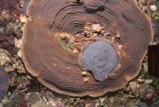
Photograph of two coral colonies, one growing on top of the other, at 70 meters water depth, Pulley Ridge Reef. Photograph from Robert Halley, USGS.
Sixty-six fish species have been identified at Pulley Ridge Reef. These include deepwater and commercial species as well as those typical of shallow-water coral reefs. DNA testing is underway to determine the relationship between these deep corals and the shallower corals of the Florida Keys. The deep-water reefs on Pulley Ridge may be a new and unknown biological and geological resource. Initial results were presented to the Gulf of Mexico Fishery Management Council during July 2003. As a result, the 3000 square mile study area encompassing Pulley Ridge was designated a fisheries Habitat of Particular Concern (HAPC).

Navassa - scientific studies result in Wildlife Refuge status
Navassa is an uninhabited, 5 square kilometer
The research team conducted an inventory of the island's natural resources for the Department of Interior, Office of Insular Affairs. Preliminary results of the inventories increased the number of terrestrial species known to inhabit the island from 150 to more than 650. The expeditions found the last living specimen of the palm tree Pseudopheonix sargentti saonae var. navassana. This endemic palm had been common on the island as late as 1928.
National Wildlife Refuge Status
The information collected during these expeditions was instrumental to the 1999 decision to designate Navassa a USFWS National Wildlife Refuge. The refuge was established to preserve and protect the coral reef ecosystems and the marine environment, to restore and enhance native wildlife and plants, and to provide opportunities for wildlife research. This refuge is closed to the public.
Future opportunities
USGS has proposed to NOAA a study to map and inventory the coral reefs at Navassa. Approval is pending.
Mapping critical and National Park Pacific coral reefs
More than 60% of coral reefs in U.S. waters are found in the extended Hawaiian Island chain. USGS is working closely with academic institutions and State and Federal agencies (USFWS, NPS, and NOAA) to assess the factors that affect the health of Hawaii's and our Nation's coral reefs. In order to establish a basis from which scientists can objectively detect changes in reef health, the USGS and its cooperators are applying many new techniques to the mapping and monitoring of coral reefs in Hawaii.


Mapping coral reef landscapes requires many different types of information. Map above shows a portion of the coral reef of the south-central shore of Moloka'i. Very detailed bathymetry was obtained using lidar, a laser-ranging technique that can penetrate shallow water. Oblique view of the same portion of reef was created by digitally draping an aerial photograph over the bathymetric model. These detailed maps and images show prominent features, such as channels and large holes, and allow scientists to better understand the structure and development of reefs. From USGS Fact Sheet 084-01 (http://geopubs.wr.usgs.gov/fact-sheet/fs084-01/ ).
USGS scientists provide detailed maps of and habitat characterization of critical coral reefs in Hawaii that are of concern to resource managers and the public. Most of the changes associated with reefs in this area are related to changes in adjacent drainage basins brought about by urban development, agriculture, ranching, coastal construction, and other anthropogenic changes. The reef off south Moloka'i is threatened by siltation and pollution. This site was chosen to develop the procedures for producing detailed coral reef maps that are useful to managers and planners. Other reefs requiring geologic mapping to better understand anthropogenic change from urbanization and farming run-off include south Oahu and west Maui, respectively.