Western Coastal & Marine Geology
Western Coastal & Marine Geology Posters
|
||||||||
|
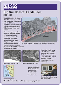
Maps Showing Estimated Sediment Yield From Coastal Landslides and Active Slope Distribution Along the Big Sur Coast, Monterey and San Luis Obispo Counties, California Map Showing Coastal Cliff Retreat Rates Along the Big Sur Coast, Monterey and San Luis Obispo Counties, California Info on "Coastal and Nearshore Erosion" Info on "Natural Hazards and Public Safety" USGS Landslide Hazards website USGS Landslide News and Information 1982-83 El Niño Coastal Erosion: San Mateo County, California Formation, Evolution, and Stability of Coastal Cliffs--Status and Trends view or download files for printing:
|
 |
 |
 |
 |
|
 |
 |

![]() U.S. Department of the Interior | U.S. Geological Survey
U.S. Department of the Interior | U.S. Geological Survey
URL: http://walrus.wr.usgs.gov/posters/bigsur.html
Page Contact Information: Laura Zink Torresan
Page Last Modified: 14 May 2008 (lzt)

