Significant Topographic Changes in the United States
|
|
Primary Findings
The research conducted for this study has resulted in new geospatial datasets that locate and describe significant topographic surface changes in the conterminous United States. In addition, summary statistics and tabulations of changed areas have been produced for several different accounting and reporting units. These results should be useful for researchers working on land change at various scales within the United States.
In reference to the primary research issue, this study has produced an inventory and assessment of individual land surface features resulting from human geomorphic activity across the conterminous United States. This inventory is quantitative, as the features have been mapped and the changes in terrain parameters have been measured for each feature. The human geomorphic features in the inventory were detected and described based on the changes to their topographic expression. The topographic change inventory is a first ever spatially explicit accounting of anthropogenic geomorphic features throughout the conterminous United States. This summary and description of the extent and nature of the vertical component of landscape change complements well ongoing studies in land use/land cover change, as the two transformations are often closely related. The results of this study demonstrate the validity of using multitemporal elevation data in an accuracy-based threshold approach to detect significant topographic changes over broad areas, thus emphasizing the value of preserving historical elevation data holdings. Because this study was based on geospatial data, the results include specific locational information for features that has not been present in previous estimates of human geomorphic activity across the United States. This spatial component has the added advantage of facilitating assessment of environmental impacts specific to the individual changed areas, including hydrologic effects and visual impacts that can extend the influence of the disturbed area into adjacent nonchanged areas.
Although nearly every state and ecoregion contains some features in the topographic change inventory, they are unevenly distributed throughout the conterminous United States (figure below).
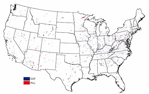
The highest concentration of topographic change polygons is found in the mountaintop mining region in eastern Kentucky and southern West Virginia (the Central Appalachians ecoregion). A distinct cluster of polygons is found in the Iron Range in northern Minnesota, resulting from open pit iron ore mining. Several larger groups of change polygons related to surface mining operations are located in Wyoming, northern Nevada, and southern Arizona. Higher densities of change polygons are found near the California cities of San Francisco, Los Angeles, and San Diego, a result of the urban development expanding into higher relief areas adjacent to the cities. Overall, the total area covered by all the change polygons (slightly less than 1,100 square kilometers) is very small (less than 0.02 percent) compared to the land area of the conterminous United States. However, the topographic change polygons are located throughout the study area, so the corresponding areas subject to environmental effects of the changes are also scattered throughout the Nation. Hence, the dual use of the topographic change inventory is recognized: the national/regional use to present broad patterns of changed areas and summary statistics within larger units (such as ecoregions), and the local use to accurately map and quantify the individual topographic change features and associated environmental effects.
It is clear from this inventory of topographic surface changes that mining is the predominant human activity responsible for geomorphic changes during the 20th century in the conterminous United States. This finding supports the conclusion from previous studies that surface mining is the largest direct anthropogenic geomorphic process in terms of the amount of material moved per unit time. The results of the study reported here add to the previous findings by quantifying and locating specific topographic changes caused by mining within different accounting units, including counties, ecoregions, watersheds, and managed areas. Quantification of the specific changes allows accounting units to be ranked in terms of area or volume of material moved. Geomorphic changes at individual mines likely have been quantified previously, but accumulating and ranking within accounting units provides context with which to compare mining impacts among regions.
This table lists the top ranked counties in terms of area of topographic changes.

Top ranked counties according to total area of topographic change polygons, with the primary type of mining responsible for the changes identified.
In each case, surface mining is the dominant anthropogenic process responsible for the changes, and the primary type of mining has been identified for each county. As with counties, the top ranked ecoregions, watersheds, and managed areas in terms of total area of topographic changes are the units that contain numerous large surface mining sites. The topographic change inventory provides spatially explicit evidence of the importance of surface mining as the primary cause of vertical landscape change across the United States. Because of their significant local magnitude and their distribution throughout the Nation, these topographic landscape changes should be included in any general discussion of anthropogenic land transformation in the United States.
It became clear while conducting this study that the data characteristics and quality of the input geospatial datasets are a primary challenge to developing reliable topographic change maps over very large areas. Perhaps this is true for any change detection study over a broad area. In this case, the unique characteristics of the elevation datasets caused a requirement for additional data processing steps. For the NED, the unique characteristics include source data from many small tiles, production artifacts, and variable source data dates. For the SRTM data, the unique characteristics include the first return nature of elevation measurements in urban and forest land cover, residual misregistration, and data voids. The mismatch among source dates for the elevation and land cover datasets also contributed to the uncertainty in characterizing change areas. Because the primary elevation and land cover datasets were used together, the data factors were combined and special processing steps had to be developed and applied to filter out falsely detected changes. If the input elevation, land cover, and reference datasets had consistent source dates, were devoid of production artifacts, and represented the same measurement (ground level for elevation data), then the somewhat subjective filtering steps could be eliminated. The NED, SRTM data, and NLCD did not have the optimal characteristics for change detection datasets; however, their existence is a unique combination of multitemporal representations of the land surface, so it was worthwhile to develop the necessary processing steps to extract meaningful land change information from them. It is unlikely that there would ever be perfect input datasets for topographic change analysis, especially over large areas, so the type of data processing methods implemented for this study provide a useful model for future topographic change studies.
The topographic change inventory would be more complete if each change feature was labeled with its origin, such as mining, quarry, road construction, urban development, or landfill. Initially, it was thought that such an attribute could be filled for each feature. However, the lack of suitable ancillary data with nationwide coverage prevents performing such a labeling automatically. Thus, the “where” (mapping) and “how much” (quantifying) questions about United States topographic change have been answered reasonably well, but the “what” (labeling) question is much more difficult to address, especially over such a broad study area. However, the labeling of topographic change features could be accomplished for local or regional areas by interested parties given suitable reference material or local knowledge of landscape processes and conditions.
Topographic change assessment complements traditional land cover change analysis. As the comparison with the land cover status and trends data showed, there is often a close correspondence between topographic change and land cover change. As more high quality, multitemporal elevation data become available, this study will provide a foundation for the addition of analyzing the vertical component, or third dimension, of landscape change as a routine part of land transformation studies.

![]() U.S. Department of the Interior |
U.S. Geological Survey
U.S. Department of the Interior |
U.S. Geological Survey
URL: http://topochange.usgs.gov/findings.php
Page Contact Information: custserv@usgs.gov
Page Last Modified: August 20, 2008
