 |
| Storm Reports |
| Are you interested in what happened during a recent event? Check out the
report below. |
|
|
 |
Big Events (2008) |
 |
| |
| 2008 has been a year of extremes in Arkansas. The
year started with a huge tornado outbreak on January 7th/8th
(especially in southwest Missouri), with a wind episode and gusts
over 50 mph on January 29th. |
 |
On February 5th, killer tornadoes took the lives
of fourteen people...with one tornado tracking a record 122 miles!
Heavy snow blanketed northern and western sections of the state on
March 6th/7th, with accumulations over a foot in some areas. |
|
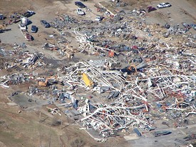
In the picture: A killer tornado (rated EF4) destroyed
a boat factory at Clinton (Van Buren County) on 02/05/2008. Fourteen
people lost their lives in Arkansas on this day.
Click to enlarge. |
| Then the flooding began after more than eight
inches of rain fell in parts of the north and west on March 17th
through the 19th. Area tributaries such as the Buffalo, Spring,
Black and White Rivers experienced Top 10 crests on record. |
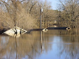 |
| In
the picture: A motel was under water along the upper reaches of
the White River at Calico Rock (Izard County) on 03/20/2008.
Click to enlarge. |
| A dozen tornadoes were spawned on April
3rd/4th across central sections of the state...including the
Little Rock (Pulaski County) area. There were high water problems
as well. This was followed by more heavy rain/flooding on April
8th through the 10th. |
| Why
So Active? |
|
A La Nina (cooler than normal water in the equatorial Pacific Ocean)
pattern was in place as 2008 began. The southern branch of the
jetstream (the Subtropical Jet), which normally flows south of
Arkansas during the Winter/early Spring months, was drawn northward.
This provided more warmth and moisture than usual, with incoming
storm systems energized and producing more extreme weather events
than normal. The severe weather season (usually from March through
May) also got an early start, with tornadoes in January. This was
also the case in 1999 (a La Nina year), with 56 tornadoes on the
21st/22nd (a record outbreak in Arkansas). |
 |
Killer tornadoes returned on May 2nd, with seven
people lost. Five of the deaths were caused by a tornado that
tracked 45 miles. More tornadoes followed about a week
later (on the 10th), mainly in central and southern Arkansas. |
|
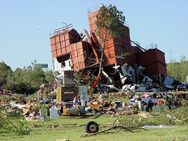
In the picture: A feed mill was heavily damaged by a
tornado (rated EF3) about 3 miles north-northeast of Damascus (Van Buren
County) on 05/02/2008. Seven people were killed on this day.
Click to enlarge. |
| How
Many Tornadoes? |
| Storms of 2008 (in PDF) |
|
Thus far, 77 tornadoes (a preliminary total) have been counted in
Arkansas. In a normal year, there are 26 tornadoes. |
On June 1st, an MCS (Mesoscale Convective System) swept across the
region with widespread wind damage reported. Then Summer arrived
and the weather slowed down as it usually does in
Arkansas.
Just as it got hot (in late July/early August), a front moved
into the region and stalled. There was a lot of rain and much
cooler temperatures on August 9th through the 12th. Some locales
in southern sections of the state received over 10 inches of
precipitation! Usually, tropical systems are responsible for
such heavy amounts in Summer. Not this time.
|
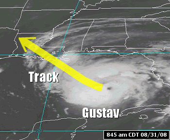
| But the tropics did come into play in September.
Hurricane Gustav reached the Louisiana Gulf Coast on September 1st. The
system brought flooding rain to Arkansas through the 4th. Strong winds were
prolonged, and frequent gusts of 30 to 40 mph downed trees and power poles. |
|
| In the
picture: The satellite showed Hurricane Gustav in the Gulf of Mexico at
845 am CDT on 08/31/2008. |
|
Less than two weeks later, Ike visited the state on September
13th/14th. The system moved quickly, so there was not as much
rain. But there was plenty of wind and isolated tornadoes.
This is an incredible chain of events. It is
rare to have such extremes occur in a calendar year. It is a
once in a lifetime experience. |
| Links of Interest |
| January 7-8,
2008 (tornado outbreak) |
| January 29,
2008 (high winds) |
| February 5,
2008 (tornadoes) |
| March 6-7,
2008 (heavy snow) |
| March 17-19,
2008 (mainly flooding rain) |
| April 3-4,
2008 (heavy rain/tornadoes) |
| April 8-10,
2008 (mainly flooding rain) |
| May 2, 2008 (tornadoes) |
| May 10, 2008 (tornadoes) |
| June 1, 2008 (wind damage) |
| August
9-12, 2008 (heavy rain) |
| September
1-4, 2008 (flooding rain/wind) |
| September
13-14, 2008 (isolated tornadoes/wind) |
|
|