Coastal Zones and Sea Level Rise
Related Links
EPA
- Climate Ready Estuaries
- Future Sea Level Change
- Recent Sea Level Change
- Saving Florida's Vanishing Shores (PDF) (3 pp., 1,284 KB, About PDF) en Español (PDF, 3 pp., 356 KB, About PDF)
- Saving New Jersey's Vanishing Shores (PDF) (3 pp., 1,337 KB, About PDF)
Sea Level Rise | Land Loss | Storms and Flooding | Response to Sea Level Rise | Coastal Water Supplies
Coastal zones are particularly vulnerable to climate variability and change. Key concerns include sea level rise, land loss, changes in maritime storms and flooding, responses to sea level rise and implications for water resources.
Sea Level Rise
Sea level is rising along most of the U.S. coast, and around the world. In the last century, sea level rose 5 to 6 inches more than the global average along the Mid-Atlantic and Gulf Coasts, because coastal lands there are subsiding.
EPA, in coordination with other agencies, is leading the development of a federal study titled “Coastal Elevations and Sensitivity to Sea Level Rise.” The study is one of 21 climate change studies being conducted by the U.S. Climate Change Science Program (CCSP). The study will include maps and other information useful for community and environmental planning. The public review draft of the report will be available on the CCSP Web site in 2008.
In addition, a series of studies have been released in support of this larger report on "Coastal Elevations and Sensitivity to Sea Level Rise."
Higher temperatures are expected to further raise sea level by expanding ocean water, melting mountain glaciers and small ice caps, and causing portions of Greenland and the Antarctic ice sheets to melt. The IPCC estimates that the global average sea level will rise between 0.6 and 2 feet (0.18 to 0.59 meters) in the next century (IPCC, 2007).
The range reflects uncertainty about global temperature projections and how rapidly ice sheets will melt or slide into the ocean in response to the warmer temperatures. Furthermore, some processes affecting sea level have long (centuries and longer) time-scales, so that current sea level change is also related to past climate change, and some relevant processes are not determined solely by climate. Climate models, satellite data and hydrographic observations demonstrate that sea level is not rising uniformly around the world. Depending on the region, sea level has risen several times the global mean rise, or has actually fallen (IPCC, 2007). While current model projections indicate substantial variability in future sea level rise at regional and local scales, the IPCC has concluded that the impacts are “virtually certain to be overwhelmingly negative” (IPCC, 2007).
 Rising sea levels inundate wetlands and other low-lying lands, erode beaches, intensify flooding, and increase the salinity of rivers, bays, and groundwater tables. Some of these effects may be further compounded by other effects of a changing climate. Additionally, measures that people take to protect private property from rising sea level may have adverse effects on the environment and on public uses of beaches and waterways. Some property owners and state and local governments are already starting to take measures to prepare for the consequences of rising sea level.
Land Loss
Coastal wetland ecosystems, such as salt marshes and mangroves are particularly vulnerable to rising sea level because they are generally within a few feet of sea level (IPCC, 2007). Wetlands provide habitat for many species, play a key role in nutrient uptake, serve as the basis for many communities’ economic livelihoods, provide recreational opportunities, and protect local areas from flooding.
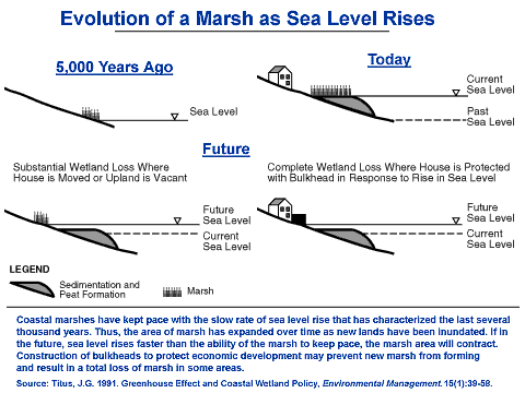 As the sea rises, the outer boundary of these wetlands will erode, and new wetlands will form inland as previously dry areas are flooded by the higher water levels. The amount of newly created wetlands, however, could be much smaller than the lost area of wetlands - especially in developed areas protected with bulkheads, dikes, and other structures that keep new wetlands from forming inland. The IPCC suggests that by 2080, sea level rise could convert as much as 33 percent of the world’s coastal wetlands to open water. (IPCC, 2007). Tidal wetlands are generally found between sea level and the highest tide over the monthly lunar cycle. As a result, areas with small tide ranges are the most vulnerable. An EPA Report to Congress estimated that a two foot rise in sea level could eliminate 17-43 percent of U.S. wetlands, with more than half the loss taking place in Louisiana (EPA, 1989).
Nationwide, about 5000 square miles of dry land are within two feet of high tide. Although the majority of this land is currently undeveloped, many coastal counties are growing rapidly. Land within a few feet above the tides could be inundated by rising sea level, unless additional dikes and bulkheads are constructed. A two foot rise in sea level would eliminate approximately 10,000 square miles of land (PDF) (26 pp., 267 KB, About PDF) including current wetlands and newly inundated dry land, an area equal to the combined size of Massachusetts and Delaware (EPA, 1989).
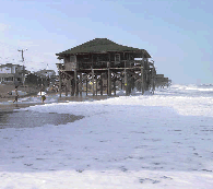
Some of the most economically important vulnerable areas are recreational resorts on the coastal barriers of the Atlantic and Gulf coasts. In many cases, the ocean-front block of these islands is 5 to 10 feet above high tide; but the bay sides are often less than two feet above high water and regularly flooded (see USGS's 7.5-minute map series). Erosion threatens the high ocean sides of these densely developed islands and is generally viewed as a more immediate problem than inundation of their low bay sides. Many ocean shores are currently eroding 1 to 4 feet per year (FEMA, 2000).
Storms and Flooding
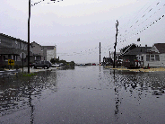 Sea
level rise also increases the vulnerability of coastal areas to flooding during
storms for several reasons. First, a given storm surge from a hurricane or
northeaster builds on top of a higher base of water. Considering only this
effect, a Report to Congress by FEMA (1991) estimated
that existing development in the U.S. Coastal Zone would experience a 36-58
percent increase in annual damages for a 1-foot rise in sea level, and
a 102-200 percent increase for a 3-foot rise. Shore erosion also increases
vulnerability
to storms, by removing the beaches and dunes that would otherwise protect
coastal property from storm waves (FEMA 2000). Sea level
rise also increases coastal flooding from rainstorms, because low areas
drain more
slowly as sea
level rises.
Sea
level rise also increases the vulnerability of coastal areas to flooding during
storms for several reasons. First, a given storm surge from a hurricane or
northeaster builds on top of a higher base of water. Considering only this
effect, a Report to Congress by FEMA (1991) estimated
that existing development in the U.S. Coastal Zone would experience a 36-58
percent increase in annual damages for a 1-foot rise in sea level, and
a 102-200 percent increase for a 3-foot rise. Shore erosion also increases
vulnerability
to storms, by removing the beaches and dunes that would otherwise protect
coastal property from storm waves (FEMA 2000). Sea level
rise also increases coastal flooding from rainstorms, because low areas
drain more
slowly as sea
level rises.
Other impacts of climate change may further enhance or mitigate coastal flooding. Flooding from rainstorms may become worse if higher temperatures lead to increasing rainfall intensity during severe storms. An increase in the intensity of tropical storms would increase flood and wind damages.
Responses to Sea Level Rise along the Coast
Property owners and federal, state, and local governments are already starting to take measures to prepare for the consequences of rising sea level. Most coastal states are working with the U.S. Army Corps of Engineers to place sand onto their beaches to offset shore erosion. Property owners are elevating existing structures in many low-lying areas, encouraged by lower flood insurance rates.
Several states have adopted policies to
ensure that beaches, dunes, or wetlands are able to migrate inland as sea
level rises.
Some states prohibit new houses in areas likely to be eroded in the next
30-60 years (e.g. North
Carolina Coastal Resources Commission ![]() ).
Concerned about the need to protect property rights, Maine, Rhode Island,
South Carolina and Texas
have implemented some version of "rolling easements," in
which people are allowed to build, but only on the condition that they
will remove the structure if and when it is threatened by an advancing
shoreline (Titus, 1998).
).
Concerned about the need to protect property rights, Maine, Rhode Island,
South Carolina and Texas
have implemented some version of "rolling easements," in
which people are allowed to build, but only on the condition that they
will remove the structure if and when it is threatened by an advancing
shoreline (Titus, 1998).
Historically, along sandy bay beaches, property
owners have erected various types of sea walls to halt erosion. Although
these hard structures protect property, they can eliminate bay beaches,
which are
usually less than 10 feet wide. Beaches are used for fishing, recreation,
transportation, and landing small crafts, in addition to their environmental
importance. The National Research Council ![]() has released a report that examines ways to minimize the loss of bayshore habitat
when protecting coastal property from shore erosion, such as the "Living Shorelines"
has released a report that examines ways to minimize the loss of bayshore habitat
when protecting coastal property from shore erosion, such as the "Living Shorelines" ![]() approach.
approach.
Through the Climate Ready Estuaries program, EPA is working with the National Estuary Programs and other coastal communities to assess climate change vulnerabilities and adapt to potential impacts.
Coastal Water Supplies
 Rising
sea level increases the salinity of both surface water and ground water through
salt water intrusion. New York City, Philadelphia, and much of California’s
Central Valley obtain some of their water from portions of rivers that
are slightly upstream from the point where water is salty during droughts.
If
sea level rise pushes salty water upstream, then the existing water intakes
might draw on salty water during dry periods. Salinity increases in estuaries
also can harm aquatic plants and animals that do not tolerate high salinity.
Rising
sea level increases the salinity of both surface water and ground water through
salt water intrusion. New York City, Philadelphia, and much of California’s
Central Valley obtain some of their water from portions of rivers that
are slightly upstream from the point where water is salty during droughts.
If
sea level rise pushes salty water upstream, then the existing water intakes
might draw on salty water during dry periods. Salinity increases in estuaries
also can harm aquatic plants and animals that do not tolerate high salinity.
Shallow coastal aquifers are also at risk (IPCC, 2007). The freshwater Everglades currently recharge Florida's Biscayne aquifer, the primary water supply to the Florida Keys. As rising water levels submerge low-lying portions of the Everglades, portions of the aquifer would become saline. Aquifers in New Jersey east of Philadelphia are recharged by fresh portions of the Delaware River which may become saline in the future.
In all of these cases, water management authorities currently prevent excessive salinity by releasing fresh water from reservoirs during droughts. One possible response to sea level rise would be to store more water during wet seasons so that more water can be released during droughts. However, other water management goals (e.g. flood prevention) may make it difficult to save extra water for the occasional drought. The impacts of climate change on local hydrology may offset or increase salinity increases due to sea level rise.
References
- IPCC, 2007: Climate Change 2007: Impacts, Adaptation and Vulnerability
 . Contribution of Working Group II to the Third Assessment Report of the Intergovernmental Panel on Climate Change [Parry, Martin L., Canziani, Osvaldo F., Palutikof, Jean P., van der Linden, Paul J., and Hanson, Clair E. (eds.)]. Cambridge University Press, Cambridge, United Kingdom, 1000 pp.
 - Titus, J., 1998: Rising Seas, Coastal Erosion, and the Takings Clause: How to Save Wetlands and Beaches Without Hurting Property Owners. (PDF) (121 pp., 2.09 MB, About PDF) Maryland Law Review, vol. 57, no. 4, pp. 1279-1399.
- FEMA, 2000: Evaluation of Erosion Hazards .
- FEMA, 1991: Projected Impact of Relative Sea Level Rise on the National Flood Insurance Program (PDF) (70 pp., 690 KB, About PDF) October 1991.
- EPA, 1989: The Potential Effects of Global Climate Change on the United States. Report to Congress. Washington, D.C.: U.S. Environmental Protection Agency. EPA 230-05-89-052.