skip to: page content | links on this page
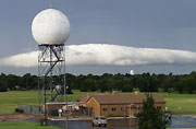
Polarimetric Doppler Radar
NSSL is involved in demonstrating the Polarimetric
Doppler Radar (Dual Pol WSR-88D)'s ability to differentiate between
different types of precipitation, and improve rainfall rate estimation.
National Weather Radar Testbed
The National Weather Radar Testbed at
NSSL provides the meteorological research community with the first surveillance
phased array radar facility available on a full-time basis. The radar is
being adapted to weather detection by a unique federal, private, state
and academic partnership. NWRT
Usage Policy
SMART-R – Shared Mobile Atmospheric Research
and Teaching Radar
NSSL collaborated with other research institutions on building two SMART-Rs;
the mobile C-band Doppler radars are used to study convective and mesoscale
atmospheric processes that occur on short time and space scales and require
flexible deployment.
Winter Hydrometeor Classification Ground
Truth Program/Hail Size Discrimination Experiment
NSSL has partnered with members of the public to collect severe weather and winter weather
observations within 90 miles of Norman, OK. The Winter
Hydrometeor Classification Ground Truth Program and the Hail Size Discrimination Experiment support NSSL scientists
involved in Polarimetric Doppler Radar development for determining what
kind of precipitation is falling at any given location.
SWAP – Severe Weather
Analysis and Prediction
By developing a storm-scale NWP science
that incorporates the latest data assimilation methods and modeling technologies,
scientists hope to move from a "warn
on detection" to "warn on forecast" paradigm
to extend warning lead times.
HWT – Hazardous Weather Testbed
The Hazardous Weather Testbed provides the framework
for development and implementation of new technologies that will have practical
benefits, including those that focus on shorter-timescale forecasting challenges.
EWP – Experimental Warning Program
The Experimental Warning Program was established to
improve the nation's hazardous weather warning services by bringing together
forecasters, researchers, trainers, developers, and user groups to test
and evaluate new techniques, applications, observing platforms, and technologies
TELEX - Thunderstorm Electrification
and Lightning Experiment
The broad objective of TELEX is to learn how lightning and other electrical
storm properties are dependent on storm structure, updrafts, and precipitation,
information that will point to new ways for the National Weather Service
to use lightning observations to improve forecasts and warnings of hazardous
weather.
Severe Thunderstorm Climatology
The Severe Thunderstorm Climatology project estimates
the likelihood of severe weather hazards in the United States, including
threats from tornadoes, hail larger than three-quater inch, and damaging
thunderstorm winds in excess of 58 mph, using data records collected since
1980.
PACS-SONET – Pan American Climate Studies
Sounding Network
The PACS-SONET project
was designed to collect low-cost upper atmospheric data from Central and
South America. Pilot balloon observations, used at first to reanalyze the
quality of the windfields over the area, are now available in a real-time
data collection and distribution network for climate research activities
and experiments.
WDSS-II - The Warning Decision Support System-II
WDSS
-II provides a unique environment for quickly writing applications
that can access real-time and archived data, do computations on that
data and test the usefulness of derived information.
CIFLOW – Coastal and Inland
FLooding Observation and Warning project
The CIFLOW consortium
is working with NCSU to couple their existing estuary model, watershed
water quality model, and an estuary water quality model to the NSSL multi-sensor
precipitation estimation system and NWS distribution hydrologic model.
The demonstration program will facilitate evaluating and testing new technologies
and techniques to produce accurate and timely identification of coastal,
estuary and inland floods, flash floods and their impacts on the coastal
ecosystem.
National Basin Delineation Project
The objectives of the National Basin Delineation
Project are to develop,
enhance and maintain a national flash-flood-scale basin dataset in support
of the NWS Flash Flood Monitoring and Prediction (FFMP) system, and to
provide technical assistance for dataset customization efforts at local
Weather Forecast Offices.
NMQ – National Mosaic and Next Generation
QPE (Q2)
The National Mosaic and Next Generation QPE project
provides a real-time, around-the-clock, applications development and testing
environment configured to host new science applications as well as components
of current methods, including automatic algorithm comparison and verification
scoring.
HMT – Hydrometeorology Testbed Program
NSSL is participating in the Hydrometeorology
Testbed Program ![]() that
will accelerate the infusion of new technologies, models, and scientific results
from the research community into daily forecasting operations of the NWS and
its River Forecast Centers. HMT operates as a demonstration with forecasters
and researchers joining forces in an operational setting.
that
will accelerate the infusion of new technologies, models, and scientific results
from the research community into daily forecasting operations of the NWS and
its River Forecast Centers. HMT operates as a demonstration with forecasters
and researchers joining forces in an operational setting.

home · about
nssl · weather research · field
observations · news & media · education
CONTACT US · PRIVACY POLICY · DISCLAIMER · SEARCH
http://www.nssl.noaa.gov last updated 5/13/08