 |
| Yearly Reports |
| Interested in what kind of weather occurred in a recent year? Check out the
most memorable events below. |
|
|
 |
Little Rock Yearly Climate Summary (2007) |
 |
| |
| The
year 2007 will be remembered for a destructive tornado at Dumas (Desha
County) in February, a widespread freeze in April (at the beginning of the growing
season), and very hot temperatures/an expanding drought in August. As you read
various weather accounts, you may not be familiar with where events
occurred in the Little Rock County Warning Area. To help you along, refer to a map by clicking
here. Onward we go... |
|
Tornado at Dumas (February 24, 2007) |
 |
A tornado caused extensive damage in Dumas on February
24th. Dozens of homes and businesses were damaged or destroyed in
the community and surrounding area, with 27 people injured.
Fortunately, there were no deaths. |
|
In the picture: A supermarket was destroyed by a
tornado in Dumas (Desha County) on 02/24/2007. Click to enlarge. |

|
| In the picture: Severe weather reports on 02/24/2007. The
graphic is courtesy of the Storm Prediction Center in Norman, OK. |
|
|
|
This was one of at least five tornadoes spawned in southeast Arkansas
(in the Little Rock County Warning Area).
The storm system responsible for the tornadoes was surrounded by a lot
of wind energy...with strong shear (i.e. south wind at ground level and
a west to southwest wind aloft) noted. This tended to make developing
storms rotate, with the potential for tornadoes.
Tornadoes in Southeast
Arkansas on February 24, 2007
|
| Widespread
Freeze (April 8, 2007) |
| Just as the growing season began, it got cold. There was a
widespread freeze on April 8th, with temperatures in the 10s and 20s in
most areas. In some spots, it was the coldest air ever felt in April. In
Little Rock (Pulaski County), the temperature reached 28 degrees. This
tied the all-time record low for the month last set on April 7, 1971. Widespread
Freeze (April 8, 2007) |
 |
|
In the picture: Low temperatures on 04/08/2007 (in
deg F). |
| All-Time
April Records Set on the 8th |
| Site |
Record
Low (Previous Record) |
| Batesville |
23T (23 on 04/11/1973*) |
| Calico Rock |
17 (19 on 04/11/1989*) |
| Fayetteville |
17 (18 on 04/05/1920) |
| Gilbert |
16 (18 on 04/11/1989*) |
| Hot Springs |
24 (26 on 04/11/1989*) |
| Little Rock |
28T (28 on 04/07/1971*) |
| North Little
Rock |
30T (30 on 04/07/2007*) |
| Note:
"T" means record was tied. "*"
means record occurred in previous years. |
|
Hot Weather/Drought (August, 2007) |
 |
A big dome of high pressure settled over the middle of
the country to begin August. Under the high, hot and dry weather
occurred. |
|
In the picture: High pressure ("H") built over Arkansas in late
July/early August, 2007...with hot and dry weather and worsening drought conditions. |
| In northern and eastern Arkansas, average temperatures
were more than five degrees above normal...with temperatures over 95
degrees nearly every day. Also in the north and east, less than an
inch of rain fell...with some spots receiving no precipitation at all. |
| Statistics
for August, 2007 |
| Site |
Rain |
Dep
(+/-) |
Rank |
Avg Temp |
Dep
(+/-) |
Rank |
Days
>= 95F |
Days >= 100F |
| Fayetteville (NW AR) |
2.54 |
-0.46 |
16 |
80.8 |
+2.9 |
4 |
9 |
2 |
| Harrison (NC AR) |
0.85 |
-2.56 |
4 |
82.7 |
+5.1 |
3 |
16 |
5 |
| Jonesboro (NE AR) |
1.00 |
-1.67 |
16 |
86.0 |
+6.2 |
1 |
27 |
7 |
| Fort Smith (WC AR) |
0.98 |
-1.58 |
9 |
84.9 |
+3.4 |
8 |
22 |
7 |
| Little Rock (C AR) |
0.14 |
-2.79 |
3 |
87.2 |
+5.9 |
T1 |
29 |
12 |
| W Memphis (EC
AR) |
0.20 |
-2.70 |
2 |
85.6 |
+6.0 |
1 |
29 |
9 |
| Texarkana (SW AR) |
0.68 |
-1.67 |
T10 |
84.4 |
+2.1 |
24 |
17 |
6 |
| El Dorado (SC AR) |
2.89 |
-0.33 |
56 |
84.1 |
+2.9 |
15 |
24 |
7 |
| Monticello (SE AR) |
0.96 |
-2.36 |
NA |
85.3 |
+5.8 |
NA |
26 |
6 |
T (in Rank Columns): Tied
Rank: Warmest
or Driest on Record
Dep
(+/-): Departure from Normal (Above/Below)
NA: Not Available |
| In the end...areas such as Harrison (Boone County),
Little Rock (Pulaski County) and West Memphis (Crittenden County) had a
Top 5 warmest and driest August. Drought conditions worsened quickly in
these areas (and in much of the northeast half of the state).
Fortunately, there was some relief in September. An increase
in tropical moisture led to heavy to excessive rain early in the month.
Hot and Dry in Little Rock
(August, 2007) |
|
Heavy Rain/Flooding (January 12-15, 2007) |
| Other headlines in 2007 included heavy rain on January
12th through the 15th. A front stalled across the state, with
precipitation focused along the front. |
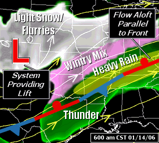 |
|
In the picture: The pattern on 01/14/07...with a front stalled from the Ohio Valley
into southern Arkansas and a storm system ("L") approaching from the Rockies. A deep southerly wind flow
was present ahead of the system, with a lot of moisture pulled northward from the Gulf of Mexico. Heavy rain
developed...and was focused near the front. |
 |
Three to five inch rainfall amounts were common across
much of the state through 7 am CST on the 15th. Many areas picked up
more than five inches of rain. |
|
In the picture: Rainfall at major reporting stations for the seventy two hour period ending
at 7 am CST on 01/15/2007. "E" is estimated precipitation. |
| While it was raining in Arkansas, it was cold enough to
support wintry precipitation north and west of the state. From Oklahoma
into southeast Kansas and into Missouri, shallow cold air yielded
icing...with rain falling into below freezing air near the ground. A
major ice storm occurred in these areas.
Heavy Rain (January 12-15,
2007) |
| High Flow Rates on
the Arkansas River (June/July, 2007) |
|
| In early July, flow rates along the Arkansas River ran over 200,000 CFS
(cubic feet per second) at times. By the end of the month, flow rates were still
between 100,000 and 150,000 CFS. Rates are normally from 20,000 to 50,000
CFS. |

|
| In the picture:
Statewide precipitation ranks for the Spring (March through May)
of 2007. The graphic is courtesy of the National Climatic Data
Center. |
|
|
|
Rates were so high due to a very wet Spring across the Plains, with well
above normal rainfall and widespread flooding. As an aside, it was very dry
in the southeast United States...which set the stage for an exceptional
drought that lasted for the remainder of the year (and built into
Arkansas in August).
|
| Tornadoes in 2007 |
|
| There were only 16 tornadoes in 2007, with 8 of these occurring on
February 24th. This was the smallest number of tornadoes since 1994, when there
were also 16.
List of Tornadoes
|
| Lightning in 2007 |
|
| Overall, there was not a lot of severe weather in 2007.
However, several structure fires were triggered by lightning...with two
people killed in one fire at Diaz (Jackson County) on December 20th.
Structure Fires Due to Lightning
|
| Unusual Storms
(April 3, 2007) |
|
| When there is severe weather, it usually does not last
long. Storms are often gone within an hour, but not on April 3rd. Very
large hail and flooding rain continued for at least a couple of hours in
west Little Rock (Pulaski County), and gave local residents a scare.
Storms in western Pulaski
County (April 3, 2007)
|
|
|


