 |
| Yearly Reports |
| Interested in what kind of weather occurred in a recent year? Check out the
most memorable events below. |
|
|
 |
Little Rock Yearly Climate Summary (2006) |
 |
| |
| The
year 2006 will be remembered for a continuing drought and a lack of
hurricanes. As you read
various weather accounts, you may not be familiar with where events
occurred in the Little Rock County Warning Area. To help you along, refer to a map by clicking
here. Onward we go... |
|
The Drought |
 |
The drought which began in May, 2005 lasted throughout
2006. A lack of ground water was most noticed across southwest
sections of the state, with rainfall deficits over a foot in some
areas as the year closed. |
|
In the picture: Rainfall percentages of normal in 2006.
Values were highest across the north (125% to 150% of normal in spots)
and lowest in the southwest (50% to 75% of normal in spots). |
| Toward the end of the year, there was vast improvement
across northern sections of the state...with above to well above normal
rainfall totals from September
through November (which wiped out the drought). While southern Arkansas enjoyed surplus rain in December, minor to
moderate drought conditions persisted into the new year. There is some
good news to report. In 2005, the average precipitation across the state
was only around 35 inches (normal is 49 inches)...which ranked as the 2nd
driest year. Precipitation averaged close to 46 inches in 2006, which did
not even rank in the top 50 driest years. |
| Rainfall
Totals in 2006 |
|
Site |
Rain |
Norm |
+/- |
| Fayetteville (NW AR) |
45.01 |
43.54 |
+1.47 |
| Harrison (NC AR) |
42.27 |
43.23 |
-0.96 |
| Jonesboro (NE AR) |
51.28 |
46.18 |
+5.10 |
| Fort Smith (WC AR) |
50.26 |
43.87 |
+6.39 |
| Little Rock (C AR) |
48.75 |
50.93 |
-2.18 |
| W Memphis (EC AR) |
46.67 |
52.90 |
-6.23 |
| Texarkana (SW AR) |
36.48 |
47.38 |
-10.90 |
| El Dorado (SC AR) |
40.70 |
54.11 |
-13.41 |
| Monticello (SE AR) |
50.40 |
55.66 |
-5.26 |
| Lack of Hurricanes |
|
| The tropical Atlantic Ocean featured 28 named storms in
2005. This broke the record of 21 storms set in 1933. In 2006, there were
only 10 named storms...with nothing after early October (the season
finished on November 30th). There were only 2 major hurricanes
(Category 3 or higher with sustained winds of 111-130 mph), and these did
not affect the United States. There were 7 major hurricanes in 2005. Why
the slowdown? It appears that El Nino was at least partly
responsible. An emerging El Nino usually features increasing winds aloft
which disrupt hurricane development. Tropical activity often declines. |
| Severe
Weather/Flooding |
|
| Of all of the big severe weather events during the year,
none stands out more than the huge hail produced on April 2nd. There were
at least seven reports of 4 inch diameter hail or larger in eastern
Arkansas. The largest hail report came from just north of Searcy (White
County), where 5 inch hail was noted. There were four tornadoes spawned as
well, with major damage at Marmaduke (Greene County) and near Wynne (Cross
County). Severe Weather (April
1-3,
2006) |
 |
|
In the picture: Where 4 to 5 inch diameter hail was reported on 04/02/2006. |
|
|
|
|
Another big event occurred on September 21st through the 23rd. Northern
and western sections of the state were impacted this time, with half a
dozen tornadoes developing. But the big story was the
flooding. Storms developed over the same areas near the Arkansas and
Missouri border. Twenty four hour rainfall totals were over 7 inches in
places...and over 11 inches for the event. The high water that resulted
killed two people in Sharp County.
Severe Weather/Flooding (September 21-23,
2006)
|
| Have you ever witnessed flash flooding that occurred
within minutes? On April 29th, that is exactly what happened. In west
Little Rock (Pulaski County), excessive rain led to $1.8 million in damage
at a car dealership. Flash
Flooding (April 29, 2006) |
| Tornadoes |
|
| There were 25 tornadoes in 2006, which is about normal
for Arkansas. There were no tornado deaths, but there were 70 injuries.
Many of the injuries (47 of them) were associated with a strong tornado
on April 2nd that tracked from near Pocahontas (Randolph County) to
Caruthersville, MO. The majority of tornadoes (16 of them) during the
year were spawned in March and April.
Tornadoes
in 2006
|
|
Hot Weather/Cold Weather |
 |
The hottest period of the year occurred during the
hottest month...July. On the 19th through the 21st, high temperatures
were in the upper 90s to around 105 degrees in most areas. Several
records were tied or broken. |
|
In the picture: High temperatures on 07/21/2006. |
| Site |
Record
High (Date of Occurrence) |
| El Dorado |
104T (07/19) |
| Fort Smith |
104T (07/21) |
| Harrison |
104T (07/20) |
| Hot Springs |
103 (07/01), 108T
(07/19), 108 (07/20) |
| Little Rock |
104 (07/19), 104 (07/21) |
| North Little Rock |
104T (07/19), 104
(07/20), 101 (07/21) |
| Pine Bluff |
103T (07/21) |
| Note:
"T" means record was tied. |
| On the flip side, the coldest air of the year settled
across Arkansas during the morning of December 8th. Temperatures were in
the single digits and teens, with a few more records. |
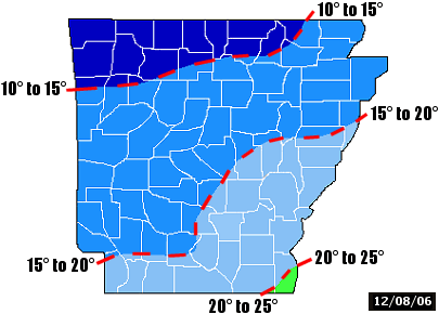 |
|
In the picture: Low temperatures on 12/08/2006. |
| Site |
Record
Low (Date of Occurrence) |
| Camden |
14 (12/08) |
| Conway |
14T (12/08) |
| El Dorado |
16T (12/08) |
| Gilbert |
6 (12/08) |
| Hot Springs |
12 (12/08) |
| North Little Rock |
15 (12/08) |
| Note:
"T" means record was tied. |
|
Winter Storm |
 |
Quite a Winter storm affected Arkansas on February
17th through the 20th. A front pushed through the region from the
northwest, with
temperatures dropping more than 50 degrees in some areas in less than
24 hours! Snow fell across the
northern counties, with 2 to 6 inch accumulations common.
Winter Storm (February 17-20, 2006) |
|
In the picture: Snowfall in northern Arkansas as of 2 pm CST on
02/18/2006. |
|
|


