 |
| Storm Reports |
| Are you interested in what happened during a recent event? Check out the
report below. |
|
|
 |
May 2008 Storm Report |
 |
| |
| Short Weather Summary |
| |
| Severe weather was the
headliner in May, especially during the first half of the month.
Tornadoes were spawned on the 2nd, with Conway and Van Buren Counties
the hardest hit areas. Seven people were killed during the event. More
tornadoes followed on the 10th, with extensive damage in Arkansas
County. |
|
| There was one record high temperature tied
on May 9th, and a record low temperature on the 16th. Check
out the records below. |
| Site |
Record
High (Date of Occurrence) |
| El Dorado |
90T (05/09) |
| Note:
"T" means record was tied. |
| Site |
Record
Low (Date of Occurrence) |
| North Little Rock |
50 (05/16) |
|
A line of strong to severe thunderstorms pushed into
Arkansas from the Plains toward dawn on the 2nd. Ahead of the line, scattered
supercells (storms with rotating updrafts) popped up and spawned several
tornadoes. |
|
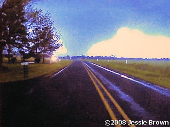
In the picture: A wedge shaped tornado entered Van
Buren County from Conway County as witnessed along Highway 285 between
Damascus and Rabbit Ridge (both in Van Buren County) on 05/02/2008. The
picture is courtesy of Jessie Brown. |
| The strongest tornado (rated EF3) affected areas from
around Birdtown (Conway County) to Damascus (Van Buren County) and
Greers Ferry (Cleburne County). The tornado caused extensive structural
damage, and killed five people.
Ironically, the heaviest rain fell where some of the worst tornado
damage occurred. Around Damascus (Van Buren County), people with rain
gauges who were interviewed during tornado damage surveys reported up to
7 inches of precipitation!
|
| Another tornado (rated EF2) affected areas south of
Wrightsville near Hensley and Woodson (all in Pulaski County), with one
person killed. |
|
|
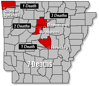
In the picture: Storms claimed the lives of at least
seven people in Arkansas on 05/02/2008. |
| Other tornadoes were noted at Carlisle (Lonoke County)
and south of Sheridan (Grant County) near the Cross Roads
community. |
|
On the 10th, tornadoes returned to the region.
One particular supercell produced golfball size hail just south of
Little Rock (Pulaski County) and at England (Lonoke County) before
spawning a tornado at Stuttgart (Arkansas County).
|
|
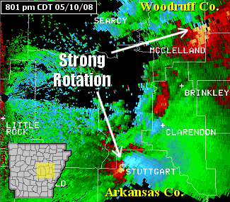
In the picture: The WSR-88D (Doppler Weather Radar)
showed strong rotation with two supercells in central Arkansas as of 801
pm CDT on 05/10/2008. The storms were likely producing tornadoes
simultaneously. |
| Major damage occurred on the south side of Stuttgart
(Arkansas County). Nine injuries were reported, with an elderly woman
trapped in her home.
Outside of Arkansas, a long track killer tornado (rated EF4) claimed
the lives of at least twenty people in eastern Oklahoma and southwest
Missouri on the 10th. Most of the fatalities occurred at Picher, OK and
Racine, MO.
|
| Additional May Details |
| |
| For more details about
May, 2008...go to the "Temperatures and Precipitation"
section below. |
| Temperatures and Precipitation |
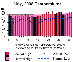
| Temperatures were generally
below during the first half of May, and above normal to end of the month.
Overall, readings were close to normal. |
 |
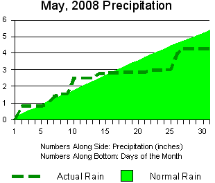 |
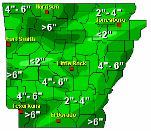
Rainfall was at or above normal in portions of north
central, southwest and extreme southeast Arkansas. Elsewhere, below normal
precipitation was measured. Amounts at Little Rock are shown to
left. |
| To right, a look at precipitation across the state. |
 |
| For a look at actual temperatures and precipitation
in Arkansas as measured by the cooperative observer network, click
here. |
|
|