|
In a hurry? Save or print these Collection Connections as a single file.
Go directly to the collection, Map
Collections: 1500-2004, in American Memory, or view a Summary
of Resources related to the collection.
Using Map Collections: 1500-2004, students can build
historical-thinking skills through the study of maps and
their features.
1) Chronological Thinking
Using the Cities and Towns
category, students can launch local history projects that develop chronological thinking skills.
Search for maps of a city or state
from different periods, then compile a list of changes over time as shown by the maps. For
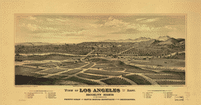
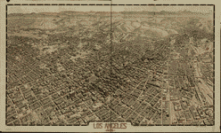
example, students might search on Los Angeles and find these two panoramic maps:
Using the Santa Monica Hills as a reference point, one might explore questions such as:
- Between 1877 and 1909, how did the city of Los Angeles change?
- Do the maps give any indication of the importance of the railroad to the city's development?
- Transportation was moving from horse and buggy to automobile in 1909. What evidence of this change is depicted in the 1909 map of Los Angeles.
- Why did Hollywood become a good location for the early motion picture industry? How did the development of that industry affect the the rest of the Los Angeles area? Had Hollywood attained any significance by 1877? By 1909? Is it depicted on either of these maps?
The orientation of a map often indicates the importance given certain physical features depicted on the map. Given the orientation of the 1877 map, do you believe that the ocean or the Los Angeles River was of greater importance to most Los Angeles residents? Why? On what does the 1909 map focus the viewer's attention?
2) Historical Comprehension
|

The
United States of America. . . , 1783 (detail)
|
Students can begin to comprehend how settlement of and sovereignty over places
affect the content of maps throughout history. For example, students might study
the map The
United States of America Laid Down from the Best Authorities, Agreeable to the
Peace of 1783 which was drawn the year the Treaty
of Paris officially ended the Revolutionary War.
Ask students to find evidence of British rule in place names (such as Williamsburg,
Baltimore, Lancaster). Ask students to find evidence of Native American settlements
in place names (such as Chingoteak Island, Pocomoak Bay, Potoromack River) and
to research how these names have changed over time. Students might also discover
the absence of Washington, D.C., on the map, and discuss how American self-government
would change features of the map in the future.
|
3) Historical Analysis and Interpretation
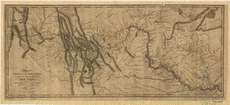
Students can analyze A
Map of Lewis & Clark's Track. . . to find a record of the explorers' encounters with Native Americans.
For example, students might study the map to find notations made on the map regarding Native-American customs and activities.
Examples of handwritten notes found on this map are: "Between these Rivers the different Bands of SIOUX meet every
Spring to trade with each other and the white Traders who visit them," and "Here the different tribes
meet in Friendship and collect Stone for Pipes."
Students might consider why Lewis and Clark recorded this information and then research the
history of the tribes as other peoples moved west. Students could discuss how Lewis and Clark's
expedition influenced the lives of Native Americans they encountered.
Search on Indian for later maps that
reflect resettlement of native peoples by the U.S. Government.
4) Historical Issue-Analysis and Decision Making
Students can launch a number of research projects using the bibliographic records and
content of maps they uncover in this rich collection. For example, students might
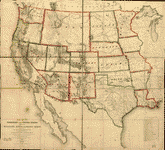
search on United States
Territory West to find this 1858 map of the Western territory.
Students can study the thorough bibliographic record for the map to investigate questions such as:
- For what president was Jefferson Davis Secretary of War in the 1850s?
- Why would Davis order such a map?
- What did railroads have to do with defense at the time?
5) Historical Issue Analysis and Decision Making
|
|
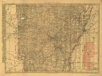
.
. . Arkansas showing all railroad, cities, towns, villages, post offices,
lakes, rivers, etc ., 1898
|
Set the following scene for students: "You are a railroad magnate who must
plan for railroad expansion in the state of your choice. Using the Subject
Index for the Transportation
and Communication map category, select a state railroad map and find the capital
city. Next, research the state and city at the time the map was made."
Students should find the answers to the following questions:
- What were the key industries?
- What were the important surrounding states and cities?
- What competing modes of transportation existed?
- Where were the railroads at the time?
Or, a student might take on the role of mayor of a town that does not have
a train station and the task of persuading the railroad company to bring the trains
to the town.
|
|