| The Library of Congress | |
|
|
|
collection
connections single file for printing |
|
summary of resources
|
|
|
Map Collections: 1500-2004 brings Americana and cartographic treasures of the Library of Congress online, covering approximately four hundred years of map making. Students can study maps from seven theme categories to learn about the changing face of America and the evolution of map-making techniques throughout history: Cities and Towns, Conservation and Environment, Discovery and Exploration, Cultural Landscape, Military Battles and Campaigns, Transportation and Communication, and General Maps. Within these categories there are links to other collections: Panoramic Maps, 1847-1929, Mapping the National Parks, Maps of Liberia, and Railroad Maps.
1) Cities and Towns
Students can study the development of the nation's capital using Pierre Charles L'Enfant's historic 1791 plan for Washington, D.C. Using the National Park Service site on the National Mall, students can compare today's mall with L'Enfant's original plan.
2) Conservation and Environment
The Yellowstone Maps Collection shows how individual explorers and map makers influenced the national parks. For example, between 1870 and 1878, Ferdinand Vandeveer Hayden conducted a United States Geological Survey of Yellowstone. With him were William Henry Jackson as official photographer and Thomas Moran as accompanying artist. Their work from the expedition was publicized in the East and helped spur designation of Yellowstone as the first national park in 1872. Search on Hayden to find maps of the Yellowstone region made under his direction.
3) Discovery and Exploration
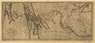
This category documents the European discovery and exploration of the Americas. Many of the maps reflect the Age of Discoveries (fifteenth to seventeenth centuries) when Europeans focused on drawing outlines of the continents they explored and on mapping coastal areas and major waterways. This category also includes eighteenth and nineteenth century maps that document exploration of the interior of continents and the work of government explorers and surveyors. Search on Clark or use the Discovery and Exploration Maps Title List to find the map shown above documenting Lewis and Clark's track. This map can serve as a springboard for research about the Lewis and Clark Expedition. Using the bibliographic record, students can find information about when the expedition occurred, what the expedition route was, who made the map, and when the map was created.
4) Cultural LandscapeThis section includes census maps and land-ownership records that reveal the ethnic origins of settlement areas as well as maps that record the establishment of farmsteads and villages. This category also contains the "American Colonization Society Collection of Maps of Liberia".
Students can use this map to launch research on the nation's first president. Students might locate the Potomac river (spelled Potomack on this map). Students might then use the bibliographic record of the map to discover that Washington himself was the map maker and to determine Washington's age when he made the map.
5) Military Battles and Campaigns
Students can use this category to study maps of the Revolutionary War. From the Military Battles and Campaigns Maps Title List, select maps with dates ranging from 1776 through 1783 (when the Treaty of Paris officially ended the Revolutionary War). For example, students might discover a 1775 map of Boston and its environs.
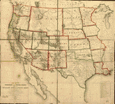
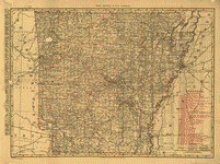
6) Transportation and CommunicationThe maps in this category document the development of national, state, and local transportation and communication systems. Transportation maps show canal and river systems, cycling routes, railways, roads, and traffic patterns. Communication maps illustrate telegraph routes, telephone systems, and radio coverage. This category contains individual maps and the Railroad Maps Collection.
This map, made just nine years after the first successful telegraph message was sent, can help students study the growth of telecommunications in the United States. Students might examine the map to locate states with the greatest number of telegraph stations and then answer questions such as:
7) General MapsGeneral maps portray geographic areas larger than cities or towns. A wide variety of historic and current regional, state, country, and world maps is included. These maps show change within a region throughout time as well as the development of the map-making process.Students can look carefully at historical atlases in the collection and compare them with an atlas of today. Search on atlas or explore the Special Presentation on "Atlases" to find maps drawn and hand colored in the sixteenth century. Students might then discuss questions such as:
|
|
Using Map Collections: 1500-2004, students can build historical-thinking skills through the study of maps and their features.
1) Chronological ThinkingUsing the Cities and Towns category, students can launch local history projects that develop chronological thinking skills. Search for maps of a city or state from different periods, then compile a list of changes over time as shown by the maps. For example, students might search on Chicago and find these three panoramic maps:
Using the mouth of the Chicago River as a reference point, students might answer questions such as:
2) Historical Comprehension
Ask students to find evidence of British rule in place names (such as Williamsburg, Baltimore, Lancaster). Ask students to find evidence of Native American settlements in place names (such as Chingoteak Island, Pocomoak Bay, Potoromack River) and to research how these names have changed over time. Students might also discover the absence of Washington, D.C., on the map, and discuss how American self-government would change features of the map in the future. 3) Historical Analysis and Interpretation
Students can analyze A Map of Lewis & Clark's Track. . . to find a record of the explorers' encounters with Native Americans. For example, students might study the map to find notations made on the map regarding Native-American customs and activities. Examples of handwritten notes found on this map are: "Between these Rivers the different Bands of SIOUX meet every Spring to trade with each other and the white Traders who visit them," and "Here the different tribes meet in Friendship and collect Stone for Pipes." Students might consider why Lewis and Clark recorded this information and then research the history of the tribes as other peoples moved west. Students could discuss how Lewis and Clark's expedition influenced the lives of Native Americans they encountered. Search on Indian for later maps that reflect resettlement of native peoples by the U.S. Government.
4) Historical Issue-Analysis and Decision Making
Students can study the thorough bibliographic record for the map to investigate questions such as:
5) Historical Issue Analysis and Decision Making
Set the following scene for students: "You are a railroad magnate who must plan for railroad expansion in the state of your choice. Using the Subject Index for the Transportation and Communication map category, select a state railroad map and find the capital city. Next, research the state and city at the time the map was made." Students should find the answers to the following questions:
Or, a student might take on the role of mayor of a town that does not have a train station and the task of persuading the railroad company to bring the trains to the town. |
|
Map Collections can form the basis for lively reading, discussion, and creative writing activities. Using the collection, students can hone their understanding of places and times in history while they develop their language arts skills. 1) Literature
Read aloud or have students read about the Lewis and Clark Expedition. Use this Lewis and Clark map to locate places described in the literature. Using the books and map, have students write an essay about or discuss the question: "What was the most important contribution of the Lewis and Clark expedition?" (Examples of important contributions might include: mapping the West and opening it for new settlement, documenting Western flora and fauna, and making contact with Native Americans.)
2) Journal Writing
3) Descriptive WritingAsk students to select a person from the "American Colonization Society" section of the Special Presentation found in America's First Look into the Camera: Daguerreotypes, 1839-1864. This person will become their research subject. Next, have students review the Special Presentation "History Of Liberia: A Time Line," and compare the dates of their subject to the time line. Finally, have students search on Liberia in the Map Collections: 1500-2004 to find a relevant map that matches the dates of their subject. Using the materials they have selected, have students write a postcard from their subject's point of view. The postcard might answer questions such as:
Students can also search on colonization or Liberia in African American Perspectives, 1818-1907, for viewpoints on the colonization movement. |
| The Library of Congress | American Memory | Contact us |
| Last updated 02/12/2004 |