


|
|
Welcome to the Wild and
Scenic
Snake River |
|||||||||||||||||||||||||||||||||||||||||||||||||||||||||||||||||||||||||||||||||||||||||||||||
|
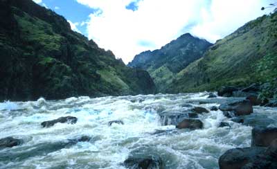
General Information: Hells Canyon National Recreation Area (HCNRA) straddles the Snake River, forming the boundary between Idaho and Oregon. The 652,488-acre recreation area was created by an act of Congress in 1975. Although the HCNRA includes portions of the Nez Perce, Payette, and Wallowa-Whitman National Forests, it is managed by the Wallowa-Whitman National Forest. The Hells Canyon Wilderness comprises nearly 215,000 acres within the HCNRA. The 31.5-mile section of the river between Hells Canyon Dam and Upper Pittsburg Landing is designated wild under the Wild and Scenic Rivers Act. This act defines wild as "free of impoundments and generally accessible only by trail" representing "vestiges of primitive America." The 36-mile section of river downstream from Upper Pittsburg Landing to mile 180.2 is designated scenic, which is defined as "free of impoundments with shorelines and watersheds still largely primitive, and shorelines largely undeveloped, but accessible in places by roads." An additional 4.2 miles of the river from mile 180.2 north to the HCNRA boundary at the Oregon-Washington line is recommended for scenic designation. The Wild and Scenic Snake River corridor extends approximately one-quarter mile back from the high water mark on each shore. The river corridor itself is not wilderness and wilderness regulations do not apply. Developed campsites and human-made structures exist, and some motorized equipment is allowed. Some areas on either side of the corridor, however, are designated wilderness, and are closed to all mechanized travel. If you want to visit the wilderness it must be on foot or horseback. Although uncommon on most wild and scenic rivers, powerboats have been used on the Snake River in Hells Canyon for many years and Congress included specific language in the Hells Canyon National Recreation Area Act which allows their continued use. Hells Canyon of the Snake River The mighty Snake River winds its way through Hells Canyon, the deepest river-carved gorge in North America. At the mouth of Granite Creek, approximately seven miles downstream from Hells Canyon Dam, the river elevation is 1,480 feet. The canyon depth here is 7,913 feet when measured from He Devil Mountain, towering over Idaho's Seven Devils range at 9,393 feet. Above Rush Creek Rapids, Hat Point Lookout offers a spectacular view of the canyon from 6,982 feet, the highest point on the Oregon rim. The perpetuation of this unique environment is largely dependent upon you, the user. With a growing number of visitors, thoughtful and appropriate behavior by all is essential to the protection of the canyon's outstanding aesthetic and environmental values. Techniques are discussed in this guide which can allow visitors to enjoy the river to the fullest while preserving its fragile natural and cultural resources. The challenge is to pass through the area and leave no trace that you were there. Hells Canyon National Recreation Area has 925 miles of trails, which provide outstanding opportunities for hunting, fishing, backpacking, horseback riding, mountain biking, photography and many other recreational pursuits. The Snake River National Recreation Trail extends 30 miles from Pittsburg Landing to Butler Bar on the Idaho side of the Snake River. On the Oregon side, the Snake River Trail (Trail #1726) parallels the river from Dug Bar to Battle Creek, 45.5 miles. Both trails offer several loop possibilities on side trails leading up to the higher elevation bench and summit trails. Only about 12% of the National Recreation Area is accessible by roads. Handling the Snake Rafting and powerboating the rapids of Hells Canyon is not recommended for the inexperienced or poorly equipped. For floaters, portaging or lining through or around many of the rapids is difficult if not impossible. For powerboaters, open bows or overloaded boats are dangerous in rapids. It is strongly recommended that prior to running these rapids you stop and scout the water for the best and safest route. If you are at all uncertain about your white water skills, go with an experienced professional outfitter/guide service that is licensed on this river. Rapids will change considerably with different flows; some will become more turbulent and others will disappear. Water flows may vary from 5,000 cubic feet per second (cfs) in summer to 70,000 cfs or more in spring runoff. Since the river is controlled by dams, flows can vary from day to day and even hour to hour. You can obtain current and projected flow information by calling Idaho Power Company's Snake River information line at (800) 422-3143. International Scale of Rapids Whitewater rapids are rated on a scale of one through six, indicating the difficulty of each rapid at medium water level. Remember that rapids can change radically as river flows fluctuate. Be sure you know how to read the water, and scout rapids from shore if necessary to find the best route. Class I
Class II
Class III
ClassIV
Class V
Class VI
The Snake is a big river with power many river users have never experienced. You must treat this river with respect; your life depends on it. The river doesn't care! The table below gives a summary of the ratings applied to some of the important rapids in Hells Canyon at both low and high flows.
Length of Trip Floaters should allow two to three days for the trip from Hells Canyon Creek Recreation Site to Pittsburg Landing, and four to six days to Heller Bar, especially during low river flows. Power boaters should be aware that there is no gasoline available at Hells Canyon Creek, Pittsburg Landing or anywhere upriver from Heller Bar, WA. Be sure you have enough fuel to complete the trip into and back out of Hells Canyon! To help you plan your trip, the table below gives some important reference points on the river and their distances from Hells Canyon Creek Recreation Site (HCC), the Lewiston/Clarkston Valley (L/C, at Hellsgate State Park), and Pittsburg Landing (PL).
|
||||||||||||||||||||||||||||||||||||||||||||||||||||||||||||||||||||||||||||||||||||||||||||||||
 About
67.5 miles of the Snake River in Hells Canyon National Recreation
Area were designated in 1975 as a component of the
About
67.5 miles of the Snake River in Hells Canyon National Recreation
Area were designated in 1975 as a component of the
| Things
to See and Do on the Snake River |
|
| General Info | |
| Floating | |
| Powerboating | |
| The Boater's Guide | |
| River Flows | |
| Boat Ramps | |
| Fishing | |
| Wilderness | |
| Recreation Map |

![]()