| 3450 |  |
Deploying bottom mounted gravity meter off of BOWIE. Establishing gravity range for calibration of underway gravity meters |
Off San Francisco, California 1962 |
3451 |  |
Deploying bottom mounted gravity meter off of BOWIE. Establishing gravity range for calibration of underway gravity meters |
Off San Francisco, California 1962 |
3452 |  |
Early sidescan sonar record showing targets. Tests run on HILGARD ASV-82 |
Martha's Vineyard area 1963 |
3453 |  |
Early sidescan sonar record showing targets. Tests run on HILGARD ASV-82 |
|
3454 |  |
Early sidescan sonar record showing targets. Tests run on HILGARD ASV-82 |
|
3455 |  |
Example of Gulf Stream thermal wedge. Sounding artifact created by abrupt changes in water temperature. Observed on EXPLORER |
Cape Hatteras, North Carolina May 26, 1965 |
3456 |  |
Detail of Gulf Stream thermal wedge. Detail of Precision Depth Recorder record showing artifact. Observed on EXPLORER |
Cape Hatteras, North Carolina May 26, 1965 |
3457 |  |
Chart showing location of Gulf Stream thermal wedge. Observed on EXPLORER |
Cape Hatteras, North Carolina May 26, 1965 |
3458 |  |
Sidescan sonar system on SURVEYOR. Used to explore for offshore extension of San Andreas Fault |
Cape Mendocino area, California 1965 |
3459 |  |
Recovery of sidescan sonar system on SURVEYOR. Used to explore for offshore extension of San Andreas Fault |
Cape Mendocino area, California 1965 |
3460 |  |
V-fin served as underwater kite to bring sensor close to bottom. Housed bottom penetration sonar. Deployed off of EXPLORER |
Northeast coast of United States 1966 |
3461 |  |
Camera station on east rift of Mauna Kea. Cooperative studies between C&GS and USGS. Deployed off of SURVEYOR |
Hawaii 1966 |
3462 |  |
Boomerang corer rigged for release. OCEANOGRAPHER maiden voyage. Eclipse expedition to South America |
South Atlantic 1966 |
3463 |  |
Hoisting deepsea current meter assemblage over starboard rail. Gulf Stream studies off the EXPLORER |
Northeast coast of United States 1967 |
3464 |  |
Lowering a current meter buoy over the side and into the Gulf Stream. Deployment from EXPLORER |
Northeast coast of United States 1967 |
3465 |  |
Fred Naugler with Nansen cast. North Pacific oceanographic studies on the SURVEYOR |
North Pacific Ocean 1967 |
3466 |  |
Dredge sample on deck - all hands want to see what's there. On the bow of the SURVEYOR |
North Pacific Ocean 1967 |
3467 |  |
Vice Admiral H. Arnold Karo. Expedition leader on OCEANOGRAPHER round the world cruise. Karo was responsible for building the NOAA fleet of the 60's through early 90's Karo's vision was the multi-disciplinary ship. OCEANOGRAPHER used for physical, geophysical, and meteorological oceanography |
1967 |
3468 |  |
OCEANOGRAPHER hosting Princess Grace of Monaco. Captain Arthur Wardwell to her left. Inport at Monaco on first leg of around the world expedition OCEANOGRAPHER around the world cruise |
Monaco 1967 |
3469 |  |
OCEANOGRAPHER in Odessa, USSR. Conducted cooperative studies with USSR in Black Sea. OCEANOGRAPHER around the world cruise |
Odessa, USSR 1967 |
3470 |  |
Deep discovered by OCEANOGRAPHER in Red Sea. This and other similar deeps contained hot brines. Another confirmation of the Theory of Seafloor Spreading. OCEANOGRAPHER around the world cruise |
Red Sea 1967 |
3471 |  |
Water sample bottles in a mess. Caption - "Sometimes things go wrong". OCEANOGRAPHER around the world cruise |
Red Sea 1967 |
3472 |  |
H. Arnold Karo conferring with Russian and Indian scientists. OCEANOGRAPHER around the world cruise. |
Indian Ocean 1967 |
3473 |  |
Micronekton net deployed. OCEANOGRAPHER around the world cruise |
1967 |
3474 |  |
Water sample bag for radio-isotope studies. OCEANOGRAPHER around the world cruise |
1967 |
3475 |  |
Water sample bag for radio-isotope studies on deck. Water sample bag for radio-isotope studies |
1967 |
3476 | 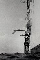 |
Swim call in the Arabian Sea. OCEANOGRAPHER around the world cruise |
Arabian Sea 1967 |
3477 |  |
Bottom photograph - compass used to orient photo. OCEANOGRAPHER around the world cruise |
1967 |
3478 |  |
Paul Grim (sitting) and George Peter working on heat probe package. OCEANOGRAPHER around the world cruise |
Indian Ocean 1967 |
3479 |  |
Deploying 20' piston corer and heat probe. OCEANOGRAPHER around the world cruise |
Indian Ocean 1967 |
3480 |  |
Bottom samples from dredge haul south of Australia. Robert F. Dill on left. OCEANOGRAPHER around the world cruise |
South Australia Basin, Indian Ocean 1967 |
3481 |  |
Bottom samples from dredge haul south of Australia. Robert F. Dill and Robert S. Dietz on right. OCEANOGRAPHER around the world cruise |
South Australia Basin, Indian Ocean 1967 |
3482 |  |
Dr. Dill expounding on his views of the geology of the South Australia Bight. OCEANOGRAPHER around the world cruise |
South Australia Basin, Indian Ocean 1967 |
3483 |  |
Robert S. Dietz looks on as Robert F. Dill monitors precision depth recorder. OCEANOGRAPHER around the world cruise |
South Australia Basin, Indian Ocean 1967 |
3484 |  |
Rough weather during oceanographic operations on stern. OCEANOGRAPHER around the world cruise |
South Australia Basin, Indian Ocean 1967 |
3485 |  |
Rough weather in the Roaring 40's south of Australia. OCEANOGRAPHER around the world cruise |
South Australia Basin, Indian Ocean 1967 |
3486 | 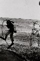 |
Lieutenant Larsen heading over the side to check if propeller fouled. OCEANOGRAPHER around the world cruise |
South Australia Basin, Indian Ocean 1967 |
3487 |  |
Neuston tow for surface biological sampling. Tow off of MT. MITCHELL |
Georges Bank, Massachusetts 1977 |
3488 |  |
Bongo nets flying in the wind prior to deployment. |
|
3489 |  |
Bongo nets on OCEANOGRAPHER during DOMES project. DOMES - Deep Ocean Mining Environmental Study |
Tropical Pacific 1976 |
3490 |  |
Large surface tow nets on OCEANOGRAPHER during DOMES project. DOMES - Deep Ocean Mining Environmental Study |
Tropical Pacific 1976 |
3491 |  |
Large surface tow net going over the side during DOMES project. DOMES - Deep Ocean Mining Environmental Study. Off of OCEANOGRAPHER |
Tropical Pacific 1976 |
3492 |  |
Net being towed on surface during DOMES project. DOMES - Deep Ocean Mining Environmental Study. Off of OCEANOGRAPHER |
Tropical Pacific 1976 |
3493 |  |
Large surface tow net |
|
3494 |  |
Bongo nets for biological sampling at depth. On MT. MITCHELL |
Georges Bank 1977 |
3495 |  |
Bongo nets being deployed |
|
3496 |  |
Viney floats deployed from OCEANOGRAPHER during DOMES project |
Tropical Pacific 1976 |
3497 |  |
Water sample rosette |
|
3498 |  |
Conductivity-Temperature-Depth rosette with water bottles. Off of SURVEYOR |
Bering Sea 1977 |
3499 |  |
Conductivity-Temperature-Depth rosette with water bottles. At the edge of the pack ice. Off of SURVEYOR |
Bering Sea 1977 |

