| 3500 | 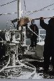 |
Bering Sea Conductivity-Temperature-Depth rosette. A cold nasty day in the Bering Sea. Off of SURVEYOR |
Bering Sea 1977 |
3501 |  |
Deploying Conductivity-Temperature-Depth rosette. Note safety lines and hard hats |
|
3502 |  |
90-liter Bodmar water sample bottle going down. |
|
3503 | 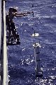 |
90-liter Bodmar bottle for relatively large deep-water samples |
|
3504 |  |
Multi-port water sampler at deep-water dumpsite. Off of MT. MITCHELL |
Off New Jersey coast 1978 |
3505 |  |
Current meter for deployment from deep-ocean moored buoy. Deployed off of OCEANOGRAPHER on DOMES project. DOMES was a study to determine the environmental impact of ocean mining |
Tropical Pacific Ocean 1976 |
3506 |  |
Pegasus profiler deployed from stern of NOAA Ship RESEARCHER. Note ship's propellers |
1986 |
3507 |  |
Deploying deep-ocean moored buoy. Current meter, water-temperature sensor, and meteorological instruments on buoy |
|
3508 |  |
Deploying deep-ocean oceanographic buoy |
|
3509 | 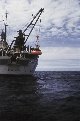 |
Deploying deep-ocean oceanographic buoy. Off of OCEANOGRAPHER |
|
3510 |  |
Making final adjustments to instruments on buoy |
|
3511 |  |
Deploying deep-sea oceanographic buoy in rough seas |
|
3512 |  |
Recovering drift buoy dropped from aircraft in North Pacific. Recovery on SURVEYOR - Photo #1 of sequence |
North Pacific Ocean |
3513 | 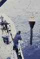 |
Recovering drift buoy dropped from aircraft in North Pacific. Recovery on SURVEYOR - Photo #1 of sequence |
North Pacific Ocean |
3514 |  |
Recovering drift buoy dropped from aircraft in North Pacific. Recovery on SURVEYOR - Photo #1 of sequence |
North Pacific Ocean |
3515 |  |
Activating acoustic release mechanism of BISP. BISP - Benthic Interface Sensing Package. On NOAA Ship PEIRCE |
Off Delmarva Peninsula, Mid-Atlantic coast of U.S. 1985 |
3516 |  |
BISP breaks surface after leaving anchors on bottom. BISP - Benthic Interface Sensing Package. On NOAA Ship PEIRCE |
Off Delmarva Peninsula, Mid-Atlantic coast of U.S. 1985 |
3517 |  |
BISP being released and beginning trip to bottom. BISP - Benthic Interface Sensing Package. On NOAA Ship PEIRCE |
Off Delmarva Peninsula, Mid-Atlantic coast of U.S. 1985 |
3518 |  |
Grappling hook to secure BISP to cable prior to recovery. BISP - Benthic Interface Sensing Package. On NOAA Ship PEIRCE |
Off Delmarva Peninsula, Mid-Atlantic coast of U.S. 1985 |
3519 |  |
BISP ready for release. BISP - Benthic Interface Sensing Package. On NOAA Ship PEIRCE |
Off Delmarva Peninsula, Mid-Atlantic coast of U.S. 1985 |
3520 |  |
Sensing units on BISP. Measured rate of biological respiration in bottom sediments. BISP - Benthic Interface Sensing Package. On NOAA Ship PEIRCE |
Off Delmarva Peninsula, Mid-Atlantic coast of U.S. 1985 |
3521 |  |
ABLS - Automated Boundary Layer Sampler. Ready for deployment off of PEIRCE. Yellow instrument on deck is a box corer |
Cape Hatteras area, North Carolina 1985 |
3522 |  |
Deploying ABLS unit off of PEIRCE. ABLS - Automated Boundary Layer Sampler |
Cape Hatteras area, North Carolina 1985 |
3523 |  |
Night recovery of ABLS unit off of PEIRCE. ABLS - Automated Boundary Layer Sampler |
Cape Hatteras area, North Carolina 1985 |
3524 |  |
Large instrument package being deployed from DAVIDSON |
1985 |
3525 |  |
Chain dredge operations |
|
3526 |  |
Chain dredge recovery on RESEARCHER. Boatswain Bill Sanders in yellow hardhat |
1982 |
3527 |  |
A good chain dredge haul on the Mid-Atlantic Ridge. Dr. Peter Rona looks on, Boatswain Bill Sanders in yellow hardhat. Operations on the RESEARCHER |
FAMOUS area of Mid-Atlantic Ridge 1982 |
3528 |  |
Box coring operations during DOMES project. DOMES - Deep Ocean Mining Environmental Studies. Off of OCEANOGRAPHER |
Tropical Pacific 1975 |
3529 |  |
Box core showing high density of manganese nodules. Box cores have the advantage of showing character of undisturbed ocean bottom. Off of OCEANOGRAPHER during DOMES project. DOMES - Deep Ocean Mining Environmental Studies |
Tropical Pacific 1975 |
3530 |  |
Spring loaded grab sampler being deployed from PEIRCE. Studying ocean dump site off Delaware Bay |
Off Delaware Bay 1985 |
3531 |  |
Recovery of box core on the PEIRCE. Studying ocean dump site off Delaware Bay |
Off Delaware Bay 1985 |
3532 |  |
Grab sampler being deployed. Bottom sampling in support of nautical charting. Determination of bottom characteristics for anchoring |
Alaska |
3533 |  |
Grab sampler being deployed. Bottom sampling in support of nautical charting. Determination of bottom characteristics for anchoring |
Alaska |
3534 |  |
Orange peel sampler ready for deployment |
|
3535 |  |
Piston corers ready for deployment on Scripps research ship MELVILLE |
|
3536 |  |
Coring device being deployed from MT. MITCHELL |
Off Delmarva Peninsula, Mid-Atlantic coast of U.S. 1978 |
3537 |  |
Deploying coring device from Scripps research ship MELVILLE |
|
3538 |  |
Woods Hole Angus camera sled being deployed from RESEARCHER. During studies of deepsea hydrothermal vents on Mid-Atlantic Ridge |
FAMOUS area of Mid-Atlantic Ridge 1982 |
3539 |  |
Woods Hole Angus camera sled in water prior to being lowered to bottom. During studies of deepsea hydrothermal vents on Mid-Atlantic Ridge |
FAMOUS area of Mid-Atlantic Ridge 1982 |
3540 |  |
A bottom photograph showing flower-like crinoid stalks. |
|
3541 |  |
Towed sub-bottom profiler with shock absorber cables. Used on MT. MITCHELL |
Off Delmarva Peninsula, Mid-Atlantic coast of U.S. 1978 |
3542 |  |
Air gun for sub-bottom profiling. Able-bodied Seaman Bob Rojecki making adjustments prior to deployment. Used off of the SURVEYOR |
1972 |
3543 |  |
Underway gravity meter installed on SURVEYOR. Used to measure variations in the Earth's gravitational field |
|
3544 |  |
Magnetic anomaly map produced on SURVEYOR. Magnetic striping is readily apparent in this map of offshore California. Earlier magnetic work led directly to Theory of Seafloor Spreading. This map helped unravel the tectonic history of the Eastern Pacific Ocean. Data acquired by towed proton precession magnetometer |
1971 |
3545 |  |
Portable vans used in lieu of installed laboratory space on many ships. Vans on PEIRCE during phosphate studies off North Carolina |
North Carolina coast 1985 |
3546 |  |
Chief Boatswain Joe Dimartino operates winch - CTD operations on MT. MITCHELL. CTD - Conductivity, Temperature, Depth measurements. MT. MITCHELL CTD's used to determine ocean sound velocity structure. Sound velocity information used to correct soundings. In support of bathymetric mapping operations |
Gulf of Mexico 1991 |
3547 |  |
Chief Boatswain Joe Dimartino instructing winch operators during CTD operations. CTD - Conductivity, Temperature, Depth measurements. MT. MITCHELL CTD's used to determine ocean sound velocity structure. Sound velocity information used to correct soundings. In support of bathymetric mapping operations |
Gulf of Mexico 1991 |
3548 |  |
Captain A. Theberge and Lt. Mike Abbott discuss ship-handling during CTD's. Chief Boatswain Joe Dimartino watches over winch operator during CTD operations . CTD - Conductivity, Temperature, Depth measurements. MT. MITCHELL CTD's used to determine ocean sound velocity structure. Sound velocity information used to correct soundings during bathymetric mapping |
Gulf of Mexico 1991 |
3549 |  |
Captain Theberge and Lt. Abbott monitoring CTD operations. CTD - Conductivity, Temperature, Depth measurements. MT. MITCHELL CTD's used to determine ocean sound velocity structure. Sound velocity information used to correct soundings. In support of bathymetric mapping operations |
Gulf of Mexico 1991 |

