 |
| Storm Reports |
| Are you interested in what happened during a recent event? Check out the
report below. |
|
|
 |
March 2007 Storm Report |
 |
| |
| Short Weather Summary |
| |
| A late Spring pattern developed in March, with a ridge of high pressure
building over Arkansas and storm systems forced to go north and west of
the region. While the ridge broke down to close the month, and there was
more rain and spotty severe weather...March ended with above normal
temperatures and below normal precipitation. |
|
| While it was a warm March, there were very few record
high temperatures. There were four records in all...mainly during the
last week. Check
the records below... |
| Site |
Record
High (Date of Occurrence) |
| Batesville |
83T (03/30) |
| North Little Rock |
83 (03/24), 84 (03/29),
84 (03/30) |
| Note:
"T" means record was tied. |
| Blocking Pattern |
|
| The month started with severe storms and hail across
northern Arkansas on the 1st. After that, intense storm systems developed in the
Rockies...with
ridges of high pressure aloft east of the systems. That created a south to southwest wind
flow over the region, with much warmer than normal
temperatures at times. |

|
The ridging was most prevalent during the latter half of
March. Storm systems had difficulty penetrating through the ridges, and
tended to move more toward the north than the east. This left Arkansas
mostly dry. In Little Rock (Pulaski County), for example, there were
only 7 days with measurable rainfall. Locally, it was the 3rd warmest
and 10th driest March on record (since 1880). |
|
In the picture: A blocking pattern set up in the days leading up to 03/24/2007.
High pressure ("H") to the south and east of Arkansas
held up an intense storm system ("L") in the
Plains. Given this, showers and thunderstorms mainly developed north
and west of the state.� |
| By the 27th, ridging broke down enough to allow a storm
system to arrive from the southern Plains. Scattered thunderstorms
popped up...especially across the southern half of the state. Some wind
damage occurred between Bonnerdale (Hot Spring County) and Hot Springs
(Garland County). |

|
| In the picture:
A loop showing a storm system ("L") and stormy weather
approaching Arkansas from 12 pm CDT on 03/30/2007 to 12 pm CDT on
03/31/2007.� |

|
A more intense system and widespread precipitation arrived
late on the 30th and into the 31st. There was heavy rain and a little
severe weather in southern Arkansas...with numerous trees downed and
some roof damage occurring in Rison (Cleveland County). Two to four
inches of rain fell from Camden (Ouachita County) northeast to Fordyce
(Dallas County), Rison (Cleveland County) to near Pine Bluff (Jefferson
County). |
|
In the picture: Twenty four hour rainfall through 7 am CDT
on 04/01/2007. |
| Additional March Details |
| |
| For more details about
March, 2007...go to the "Temperatures and Precipitation" section
below. |
| Temperatures and Precipitation |
| Temperatures
were well above normal in March. Readings at Little Rock are shown to right. |
 |
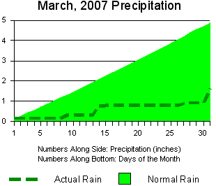 |
Rainfall was generally below normal across Arkansas. Amounts at Little Rock are shown to left. |
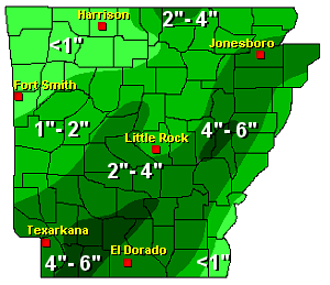
| To right, a look at precipitation across the state. |
 |
| For a look at actual temperatures and precipitation
in Arkansas as measured by the cooperative observer network, click
here. |
|
|


