 |
| Storm Reports |
| Are you interested in what happened during a recent event? Check out the
report below. |
|
|
 |
Heavy Rain on December 9-13, 2007 |
 |
| |
 |
A front was draped across Arkansas for several days in
early to mid December. At the same time,
several storm systems visited from the southwest and interacted with the front. This
caused widespread precipitation to
break out over the central United States...mainly
along and north of the front. |
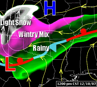
| In the picture:
The weather pattern at 1200 pm CST on 12/10/2007...with a
nearly stationary front over Arkansas and widespread
precipitation along and north of the front. |
| Temperatures varied widely across the front. In
Arkansas, high temperatures on the 8th ranged from 44 degrees at
Mountain Home (Baxter County) to 79 degrees at El Dorado (Union County)
and DeQueen (Sevier County). On the 9th, maximum readings between 12 pm
CST and 6 pm CST ranged from 35 degrees at Highfill (Benton County) to
79 degrees at El Dorado (Union County) and Monticello (Drew
County). |
| Record
High Temperatures (South of the Front) |
| El Dorado (Union
County) |
79 (12/08) |
| Little Rock (Pulaski
County) |
77 (12/09) |
| North Little Rock
(Pulaski County) |
74 (12/09) |
| As warm and moist air in southern sections of the state
pushed into cooler conditions farther north on the 8th/9th, areas of dense fog formed
over northern and central Arkansas (north of the front). Visibilities of a quarter mile or less were common, with Dense Fog Advisories
posted. |

|
| In the picture:
Temperatures and dewpoint temperatures were nearly identical in northern
and central Arkansas north of a front at 400 pm CST on 12/08/2007. When
this occurs, the air is saturated...and dense fog formed. |
 |
Precipitation began developing in the Plains late on the
8th/early on the 9th. It was cold enough for freezing rain north and
west of Arkansas, with icing from Oklahoma into Kansas and Missouri. |
| In the picture:
There were headlines in effect at 1 am CST on 12/09/2007, with foggy
conditions in Arkansas and wintry precipitation north and west of the
state. |
 |
| In the
picture: The temperature profile with height from
Kansas City, MO to Little Rock, AR showed above freezing air driven
over a shallow layer of below freezing air at 1200 pm CST on
12/10/2007. This led to icing in central/northern
Missouri, with rain farther south. |
|
|
|
Later on the 9th/early on the 10th, rain and isolated thunderstorms arrived in
Arkansas...mainly across the northwest half of the state. Several spots
received one to two inches of rain. Temperatures dropped just below
freezing in northwest Arkansas...with pockets of freezing rain and minor
icing.
There was a lull late on the 10th/early on the 11th
as precipitation shifted to the north of the region (with an ice storm in
Oklahoma, Kansas and Missouri). Areas of dense fog returned to much of
the region.
During this time frame, the front exited the state (to the north)...with
above to well above normal temperatures (60s and 70s) during the afternoon of the
11th.
|
| The front pushed back through
the region late on the 11th/early on the 12th, with widespread rain and
cooler temperatures to follow through early on the 13th. Most areas
received one to
two inches of rain...with locally more. |

|
| In the picture:
Ninety six hour (four day) rainfall totals ending at 6 am CST on
12/13/2007. Amounts were generally between 1 to 3 inches, with locally
more than 3 inches north and west of Little Rock (Pulaski County). "E" is
estimated precipitation. |
|
|


