A catalog of NASA images and animations of our home planet
Skip Navigation (key s)
.
Home
Terms of Use
Frequently Asked Questions
Browse By:
Satellite
Sensor
Collections
Country
U.S. State
GCMD Topic
All Categories
»
Geographic Regions
»
U.S. States
»
Virginia
"Fireworks" on U.S. East Coast
Landsat 7 land cover maps to …
Space radar image of Washington, …
Space Radar Image of Washington D.C.
Space Radar Image of Hampton …
Space radar image of Sunbury, …
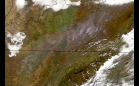
Fires in Kentucky and West Virginia
SeaWiFS: Appalachian Autumn
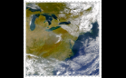
SeaWiFS: Eastern U.S. and Smoke …
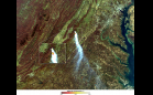
MODIS: Fires in Shenandoah …
SeaWiFS: James Bay to Southern …
Space Shuttle: Smoky Air over …
Unprecedented Fires in Southern …
SeaWiFS: North Carolina Snowfall
Birth of an Iceberg
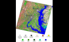
Map of Paved Surfaces
Sort By: Data Date
↑
↓
Visualization Date
↑
↓
ID
↑
↓
« ‹ 1
2
3
4
5
6
›
»
Subcategories