| Coastal Boating Guide Safety |
 |
|
|
 |
| Heading Out |
|
Aids to navigation
Oregon coastal waters are marked for safe navigation by the IALA* system of buoyage. This system employs a simple arrangement of colors, shapes, numbers, and light characteristics to indicate on which side of a buoy a boater should pass when proceeding in a given direction. The expression "red right returning" has long been a saying of seafarers to remind them that red buoys should be on the starboard (right) side when traveling from the open sea upstream into bays. Likewise, green buoys are on the port (left) side when traveling back to port.
Conversely, when proceeding toward the sea (downstream), red buoys are to port (left side) and green buoys are to starboard (right side). These buoys—their numbers, colors, and characteristics—are plotted on all nautical charts.
Buoys should not be considered permanent fixtures. They may be missing, adrift, or moved from their charted position by heavy storms, unusual tides, or collisions. Some buoys shown on charts are in position only during the summer; the Coast Guard removes them each fall to prevent winter storms from carrying them away. Off Newport, for example, buoys #2 and #3 are gone in winter.
Whistles, bells, and gongs, which are attached to some buoys, are activated by the movement of the sea; when the sea is calm, they may sound irregularly.
Buoys are anchored by a scope of chain that allows the buoy considerable leeway to move with the wind and current. Keep well clear when passing and never moor to a buoy —it is a punishable federal offense.
To help boaters navigate within channels, range markers have been erected in many rivers and bays. These consist of widely separated, brightly painted pairs of targets, or markers. Range markers are international orange with a black stripe and rectangle. They are mounted on skeleton towers or on pilings and may be in the water or on shore. Consult the appropriate navigation chart for locations of range markers. Steering a course that keeps the two range markers in line while operating in a channel marked by buoys will keep the boat within the navigable channel.
A useful reference on navigation aids is the Coast Guard publication, Light List, volume VI, Pacific Coast and Pacific Islands.
|
Small Craft
Daytime Signal | Night Signal
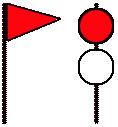
One RED pennant is displayed by day and a RED light over a WHITE light at night to indicate winds as high as 33 knots (38 m.p.h.) or sea conditions considered dangerous to small craft operations are forecast for the area.
Gale
Daytime Signal | Night Signal
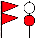
Two RED pennants are displayed by day and a WHITE light above a RED light at night to indicate that winds within the range 34 to 47 knots (39 to 54 m.p.h.) are forecast for the area.
Storm
Daytime Signal | Night Signal
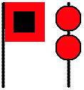
A single RED flag with a BLACK center is displayed during daytime, and two RED lights at night are displayed to indicate that winds 48 knots (55 m.p.h.) and above are forecast for the area. If the winds are associated with a tropical cyclone (hurricane), the "Storm Warning" display indicates that winds 48 to 63 knots (55 to 73 m.p.h.) are forecast. |
Charts for coastal waters
Charts of the Pacific coast are available from the U.S. Department of Commerce's National Ocean Service, which has also begun putting the most up-to-date versions of its charts on-line via its World Wide Web site at http://mapindex.nos.noaa.gov/.
The on-line charts are not suitable for navigation but are useful for planning and other purposes.
A catalog of available charts— Nautical Chart Catalog 2, United States Pacific Coast Including Hawaii, Guam and Samoa Islands —lists all charts produced for the West Coast by the National Ocean Service and is available free from:
Distribution Branch, (N/CG33) National Ocean Service, 6501 Lafayette Avenue, Riverdale, MD 20737-1199.
Individual charts—in print or on CD-ROM, in formats suitable for use in computer-based navigation systems and geographic information systems (GIS)—may also be purchased from the address above.
In Oregon, charts may be purchased from authorized National Chart Agents*:
- Astoria:
Englund Marine Supply Co Inc
Foot of 15th St
- Aurora:
Mentor Plus
22781 Airport Rd NE
- Brookings:
Chetco Chandlery Ltd
16118 Lower Harbor Rd
Lorings Lighthouse Sport Goods 554 Chetco Ave
- Coos Bay:
Charleston Basin Tackle Shop
4565 Kingfisher Rd
Englund Marine Supply Co Inc
5080 Cape Arago Hwy
- Eugene:
Libra Books Inc
856 Olive St
Wright Communications
2824 Stark St
- Florence:
Siuslaw Marina
06516 Hwy 126
- N Bend:
Oregon Pacific Company
1760 Sheridan
- Newport:
Englund Marine Supply Co Inc
880 SE Bay Blvd
Schiewe Marine Supply
103 SE Bay Blvd
- Portland:
Alder Creek Kayak Supply Inc
250 NE Tomahawk Island Dr
Boater's World, Jantzen Beach Ctr
Captain's Nautical Supply Inc
138 NW 10th Ave
Fisherman's Marine & Outdoor
1120 N Hayden Meadow Dr
Rodgers Marine Electronics
3445 NE Marine Dr
West Marine Products
021 1176 N Hayden Meadows
- Salem:
Travel Exchange
145 Liberty St NE
- Silverton:
The Compass Rose
209 Lewis St
- Winchester Bay:
Stockade Market Beach Blvd
U.S. Coast Guard Auxiliary patrols
A nationwide association of boaters, the United States Coast Guard Auxiliary is a nonmilitary organization whose main purpose is the promotion of safe boating. Auxiliary members include yachtsmen, commercial fishermen, and others experienced in handling small vessels and knowledgeable in small boat safety.
During boating season, auxiliary patrols supplement and assist the Coast Guard. Auxiliary vessels are readily identified by a blue and white flag or a large placard bearing the words "U.S. Coast Guard Auxiliary."
These vessels stay in constant communication with the regular Coast Guard patrol boats and lookout towers. Boaters may hail these vessels for information about bar conditions, tides, weather, and so forth. The regular Coast Guard often relies on auxiliary vessels to help disseminate weather reports, bar and sea conditions, and other vital information. When hailed by a Coast Guard Auxiliary boat, you should heave to and heed the information. In the event of trouble, auxiliary vessels stand by to give assistance.
|
|
|
| Hazards |
|
Crossing the bar
Most boating accidents and fatalities on the coastal bars result from capsizing. A boat is much more apt to capsize when crossing the bar from the ocean because the seas are on the stern and the operator has less control of the steerage. When looking at the bar from seaward, you don't see the front of the seas or breakers; consequently, the bar may appear much calmer than it really is.
Boaters should take every precaution when uncertain about bar conditions. Radio the Coast Guard or call another boat operator who can tell what the bar condition is. If necessary, circle the sea buoy, but make every effort to avoid danger.
Stability, a vital factor for boats cruising in coastal waters, can be aided by proper loading. An improperly loaded or overloaded craft is susceptible to capsizing. Overloading increases the risk of seas breaking aboard. It is extremely important that boats operating along the coast have adequate freeboard.
If you are caught unexpectedly on a rough bar when running in, it is imperative to keep the boat square before the seas. Keep the boat on the back of a swell. Ride the swell and keep clear of the following wave. Preserving your boat's stability is most important—a sudden shift of the passengers' weight in a small boat could prove dangerous. In fact, stability will be vastly improved in a small boat if passengers lie down in the bottom of the boat as near the center line as possible. Make sure everyone aboard is wearing a personal flotation device before crossing.
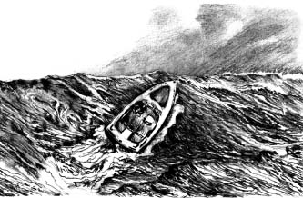
Most boating accidents on the coastal bars are caused by boat operators allowing seas to catch their boats from the side, a situation called broaching, which can result in capsizing. To prevent broaching, keep the boat square before the seas. The illustration below shows a boat about to broach.
The coastal waters of Oregon always carry a large number of drifting logs and deadheads, especially after storms, spring freshets, and unusually high tides. Boaters should always be on the lookout for logs, deadheads, and other floating debris.
*Authorized dealers as of December 1998. A current list is available on the National Ocean Service Web site: http://chartmaker.ncd.noaa.gov/ocs/text/states.html
Tides
 Along the coast of the Pacific Northwest, there are roughly two tides each day. Tides are the vertical rise and fall of the water, and a tidal current is the horizontal flow. Along the coast of the Pacific Northwest, there are roughly two tides each day. Tides are the vertical rise and fall of the water, and a tidal current is the horizontal flow.
The movement toward shore or upstream is the flood current, and movement away from shore or downstream is the ebb current. The period between these two is called slack water. Tidal currents may gain tremendous velocity, particularly when the ebb current is reinforced by a river runoff during a high-low series.
One of the greatest risks a boater can encounter is getting caught in a shallow river entrance to the Pacific—the bar—when a swift ebb current is meeting incoming westerly waves. Such conditions result in the two opposing forces meeting to pile up water and waves that break with tremendous force. Even on days when the sea is relatively calm, a fast-moving ebb has the potential to create a bar situation that could be too rough for small craft.
Boaters must always be conscious of the stage of the tide. Except on the rare occasion when the tide is unusually calm, or when you observe that the bar is down, cross from harbor to ocean on the slack or on the flood tide, when the sea is calmest.
 If you find yourself inside the bar when heavy sea conditions exist, stay there. If you are trapped outside a rough bar on an ebb tide, it is wise to lay to and wait until the flood current or inflowing current is dominant. If you are trapped outside a rough bar with a southwester developing 40-knot or better winds, whether to stay at sea with a sea anchor or risk crossing the bar becomes a matter of judgment and experience. If possible, run to another port with more favorable bar conditions. If you find yourself inside the bar when heavy sea conditions exist, stay there. If you are trapped outside a rough bar on an ebb tide, it is wise to lay to and wait until the flood current or inflowing current is dominant. If you are trapped outside a rough bar with a southwester developing 40-knot or better winds, whether to stay at sea with a sea anchor or risk crossing the bar becomes a matter of judgment and experience. If possible, run to another port with more favorable bar conditions.
Many river entrances contain sands, shoals, spits, or floats, on which waves build to the point where they become extremely dangerous to small boats. These areas should always be avoided.
Fog
Fog is often encountered in coastal water and may be thick enough to hide all landmarks and other aids to navigation. When cruising or fishing along the coast or harbor entrance, make frequent observations of your location, so that at the first sign of fog you can proceed to a sea buoy or, if practical, return to harbor.
A good, properly calibrated compass is essential for operating a vessel along the coast. A vessel attempting to run in the fog without steering a compass course could wander aimlessly. When leaving and returning to the harbor, you should record the compass course and the time required to run between buoys for reference. Remember to keep the area around the compass clear of iron or other ferrous metal objects, since they can cause compass errors.
In addition to tidal currents, there are currents that run north and south along the beaches, sometimes referred to as the "southerly set" and the "northerly set." Careful operations are necessary in foggy weather to insure that these currents do not carry your boat off course or farther from the harbor entrance than normally would be expected.
Operating a boat in fog requires that you proceed at a slow speed and keep a sharp lookout; stop occasionally and listen for other vessels, buoys, and the surf. If you become lost or unsure of your whereabouts, it is wise to anchor and wait for the fog to lift or help to arrive.
An inexpensive radar reflector or other metal object placed above the cabin on a light standard, or fixed as high as possible, will help the Coast Guard in a radar search—and may keep a boat from being run down.
International-Inland Navigational Rules require power boats operating under adverse conditions of reduced visibility to sound their whistles or horns—one prolonged blast of 4 to 6 seconds at intervals of not more than 2 minutes. A ship at anchor must ring its bell rapidly for 5 seconds every minute (check the International-Inland Navigational Rules for more information).
Dangers near large vessels
Large commercial ships frequently enter and leave the Columbia River, Yaquina Bay, and Coos Bay; ocean-going tugs make use of many smaller ports. The size of those ships makes them less maneuverable than smaller boats. Because of their deep drafts, they are required to stay within the dredged ship channel.
Accordingly, the Navigational Rules give deep-draft ships the right of way within narrow channels in all circumstances. When underway, such huge ships cannot stop readily because of their weight. Their momentum through the water will carry them forward for a great distance even after they have stopped or reversed engines. Common sense, courtesy, and the law (the rules of the road) require that small boaters give these vessels a wide berth. A good rule of thumb is to stay at least one ship length (500_600 feet) away from the ship's bow, and at least 100 feet from the ship's side as it passes.
Boaters must realize that ship pilots have a blind spot in their line of view from the bridge to the ship's bow. If a ship is bearing down on a smaller craft, the prudent boat operator will alter course promptly so the pilot will know his or her intentions. Remember: once the large vessel is on the bar or within the bay, it must remain in the channel or run aground.
If you are drifting off a harbor entrance and see a large freighter or tanker coming toward you, get underway immediately and clear the channel. In many ship-small boat collisions, it is later found that the smaller craft's engine was slow to start, resulting in a disaster that could have been avoided.
From May through October, the U.S. Army Corps of Engineers and contractor dredges are present in coastal harbor channels. Some dredges are held by anchor lines marked by buoys. Avoid both the lines and the dredge itself. Other dredges constantly maneuver. Do not pass in front of them or cut in close to them. They cannot stop or turn easily.
|
|
|
| Weather and Bar Conditions |
|
Storm signals
Storm signals are displayed at U.S. Coast Guard stations, marinas, public piers, and other locations along the Oregon coast. These warning signals predict potentially dangerous wind, or, in the case of small craft warnings, winds and seas dangerous to smaller vessels. Boaters should be familiar with these signals and heed their warnings. Remember, these warning signals represent forecasts; the wind may be calm when the signal is hoisted. It's also important to realize that the wind might be blowing or that the seas are rough enough to make boating dangerous even when no warnings are up and skies overhead are blue.
Safe boaters make it an unbreakable rule to stay ashore when storm signals are up or high winds or rough seas are present. The Coast Guard is empowered to prevent small craft from leaving protected waters when sea conditions are dangerous or storm signals are displayed—the phrase "small craft" includes boats of many sizes and designs. The Coast Guard can and will tow in boaters who refuse to heed their warnings.
Storm warnings cover a wide range of wind speeds and sea conditions. Mariners should regard storm warnings as signals that wind and sea conditions may be dangerous, or as a forecast of potentially dangerous conditions. More detailed information may be obtained by telephone or by listening to local radio stations, Coast Guard radio, or the National Weather Service VHF/FM broadcasts. The Weather Service broadcasts on frequencies of 162.4 and 162.550 MHz with transmitters at Astoria, Newport, Coos Bay, and Brookings.
Storm warning display stations (USCG day stations)
Washington Stations
Oregon Stations
- Tillamook Bay harbormaster
- Depoe Bay
- Yaquina Bay
- Siuslaw River
- Umpqua River
- (Winchester Bay)
- Coos Bay
- Chetco River
Commercial broadcast stations
The following coastal stations broadcast storm warnings and sea condition reports:
- KTIL, Tillamook 104.1 FM, daily, early morning
- KNPT, Newport 1310 AM, Twice daily, and at USCG request
- KURY, Brookings 910 AM, 95.3 FM, hourly or more if bar is rough
- KBBR, Coos Bay 1340 AM, hourly, as notified by USCG
Rough bar advisory signs
The Coast Guard has established a standard rough bar advisory sign whose location may vary from port to port. The standard sign is a 6-foot by 6-foot, white, diamond-shaped daymark with a bright orange border, with the words "ROUGH BAR" in black letters. Two alternate flashing amber lights are activated when observed seas on the bar exceed 4 feet in height and are considered dangerous.
If the lights are not flashing, this is no guarantee that sea conditions are favorable.
If you arrive at a harbor where a Coast Guard station is located, and after surveying the bar notice that it is too rough to attempt crossing into port, contact the Coast Guard via VHF channel 16 for advice and assistance.
Termination of use on coastal bars
Federal law designates certain "regulated boating areas" in the following Oregon bars and channel entrances:
- Columbia River Nehalem River
- Tillamook Bay Netarts Bay
- Siletz Bay Depoe Bay
- Yaquina Bay Siuslaw River
- Umpqua River Coos Bay Bar
- Coquille River Rogue River
- Chetco River
Check with local Coast Guard stations for the specific termination of use areas.
The regulation states: "The use of individual recreational boats can be terminated on the above-named bars or entrances when rough seas create a hazardous condition." The regulation is enforced by specially trained Coast Guard boarding officers.
|
|
|
| U.S. Coast Guard Stations |
|
Location & Telephone
- Cape Disappointment (Ilwaco, Wash.) (360) 642-2382*
- Astoria (USCG Group/Air Station) (503) 861-6211
- Tillamook Bay (Garibaldi) (503) 322-3531
- Depoe Bay (541) 765-2124
- Yaquina Bay (Newport) (541) 265-5381
- Siuslaw River (Florence) (541) 997-2486
- Umpqua River (Winchester Bay) (541) 271-2138
- Coos Bay (Charleston) (541) 888-3266
- Chetco River (Harbor) (541) 469-3885
*Emergency/Search and Rescue only
Marine emergency and distress radio procedures
Speak slowly and clearly. Call:
1. If you are in distress (that is, when threatened by grave and imminent danger), transmit the International Distress Call on channel 16: "MAYDAY, MAYDAY, MAYDAY. This is (your vessel's VHF call number and name repeated three times)."**
2. If you need information or assistance from the Coast Guard (other than when in distress), call the Coast Guard on channel 16 (the distress and calling frequency). In such cases, you will normally be shifted to a common working frequency (channel 22A), allowing the distress frequency to remain open.
CB channel 9 distress frequency is not a reliable method for reporting marine emergencies. VHF-FM channel 16 is more reliable, as is use of a cellular phone (see Coast Guard stations, this page).
If you're aboard a vessel in trouble, state the following:
1. Who you are (your vessel's VHF call number and name).
2. Where you are (your vessel's position in latitude/longitude, Loran coordinates, depth of water or true bearing, and distance in nautical miles from a widely known geographical point; local names known only in the vicinity are confusing).
3. If you require Coast Guard assistance and whether you are in immediate danger.
4. What is wrong (nature of distress, or difficulty if you are not in distress).
5. Number of persons aboard and the condition of anyone injured.
6. Kind of assistance required.
7. Present seaworthiness of your vessel.
8. Description of your vessel— length, type, cabin, masts, power, color of hull, superstructure, and trim.
9. Your listening frequency and schedule.
10. Weather conditions.
If you are reporting another vessel in difficulty, give
1. Your position and (if possible) the bearing and distance of the vessel in difficulty.
2. Nature of distress or difficulty.
3. Description of the vessel in distress or difficulty (see item 8, above).
4. Your intentions, course, speed, etc.
5. Your radio call sign, name of your vessel, listening frequencies, and schedule.
Aircraft wishing to direct surface rescue craft to a boat in distress will use the international signal, circling the surface craft, opening and closing the throttle or changing propellor pitch (noticeable by change in sound) while crossing ahead of the surface craft, and proceeding in the direction of the distress. If you receive such a signal, you should follow the aircraft. If you cannot do so, try to inform the aircraft by any available means.
If your assistance is no longer needed, the aircraft will cross your wake, opening and closing the throttle or changing the propeller pitch. If you are radio-equipped, you should attempt to communicate with the aircraft on 2182 kHz or 156.8 MHz when the aircraft makes the above signals or makes any obvious attempt to attract your attention. In the event you cannot communicate by radio, be alert for a message block dropped from the aircraft.
** If you have the radiotelephone alarm signal available, transmit it before the distress call, for approximately one minute. The radiotelephone alarm signal consists of two audio tones of different pitch, transmitted alternately. Its purpose is to attract the attention of those on watch, and it is to be used only to announce that a distress call or message is about to follow.
Signaling for assistance
In addition to the legally required visual distress signals, a boat in distress can use one or more of the following recognized distress signals:
- Fire a gun or other explosive device into the air at about one-minute intervals.
- Continuously sound any fog-signal apparatus.
- Shoot flares or rockets skyward.
- Send a message by radiotelephone.
- Wave both arms from alongside the body to over the head in an up-and-down motion.
- Wave any orange-red flag, or a garment of any size that can be attached to a fishing pole or long rod, side to side over your head.
- On the major axis of the flag, tie a 72-inch, flourescent, orange-red cloth inscribed with an 18-inch black circle and an 18-inch black square, 18 inches apart. This type of signal should also be tied to a hatch or cabin top for ready spotting by aircraft.
- SOS by spotlight.
Rendering assistance to mariners is one of the Coast Guard's primary functions, and all Coast Guard stations are on constant alert for vessels in distress. If a vessel is seen displaying or showing any unusual signal or acting in an unusual manner, the Coast Guard will always check to determine if help is needed.
Required safety equipment
Under Oregon law, children age 12 and under are required to wear a Coast Guard-approved personal flotation device at all times on boats that are underway. Exceptions include when the child is below deck or in an enclosed cabin, when a child is on board a sailboat and is tethered by a lifeline attached to the sailboat, or when a child is on board a U.S. Coast Guard-inspected passenger-carrying vessel.
Both U.S. and Oregon law require that you have certain safety equipment aboard your boat at all times. For Oregon requirements, see the Oregon Boaters Handbook, latest edition, available from the Oregon State Marine Board.
Federal regulations are contained in Federal Requirements for Recreational Boats, available from your local Coast Guard station.
Boats operating on coastal waters must be equipped with visual distress signals. The rules governing those signals vary according to the size of your boat and its type of propulsion. For further information, ask for a copy of Visual Distress Signals for Recreational Boaters at your local Coast Guard station.
Recommended safety equipment
In addition to equipment required by law, the prudent boater will carry the following extra gear:
- Anchor with suitable line for anchoring
- Survival suits for all crew members
- Retro-reflective tape on lifejackets, vests, ring buoys, rafts, and survival suits
- Emergency Position Indication Radio Beacon (EPIRB)
- VHF radio 6. Flashlight with extra batteries
- First aid kit
- Local navigation charts by the National Ocean Survey
- Emergency rations and drinking water
- Reliable and accurate compass
- Spare engine parts and tools
- Bucket for bailing
Any new line 1/2 inch in diameter will hold most boats except in severe storms—provided there is a short length of chain ahead of the anchor. The length of the anchor line should be from five to seven times the depth of the water in which the boat will be anchored. Ten to 12 feet of chain should be shackled to the anchor and fastened with a swivel to the anchor line. The long length of rope and the weight of the length of chain permit the anchor to lie flat on the bottom and the flukes to dig into the bottom to hold the boat. In severe storms, however, do not rely on any anchor and line to hold.
Another good practice of careful boaters is to equip their craft with a sturdy, solid towing bitt located near the bow. Fastenings for the towing bitt should go through a metal plate attached to the inside of the hull to prevent the bitt from pulling out, in the event the craft is taken under tow during an emergency. Small bow rings, standard on many modern trailer boats, are not strong enough for towing at sea. They frequently break under stress, with disastrous results.
Suggested reading
 Chapman, Charles F., Chapman Piloting: Seamanship & Small Boat Handling. 1996. New York: Hearst Books, Motor Boating and Sailing Division. Chapman, Charles F., Chapman Piloting: Seamanship & Small Boat Handling. 1996. New York: Hearst Books, Motor Boating and Sailing Division.- Crawford, William P., Mariner's Weather. 1992. W.W. Norton.
- Oregon Boating Facilities Guide. Salem, OR: Oregon State Marine Board.
- Nautical Chart Catalog 2: United States Pacific Coast Including Hawaii, Guam, and Samoa Islands. Riverdale, MD: U.S. Department of Commerce, National Oceanic and Atmospheric Administration, National Ocean Survey. Free from NOS and NOS agents.
- Oregon Boating Basics. Correspondence course. Salem, OR: Oregon State Marine Board.
- Oregon Boater's Handbook. Salem, OR: Oregon State Marine Board.
- U.S. Coast Pilot 7: California, Oregon, Washington, and Hawaii. 1997. Washington D.C.: U.S. Department of Commerce, National Oceanic and Atmospheric Administration, National Ocean Survey.
|
|
| |
|
|