|
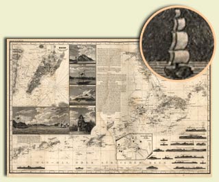
German Coastal Chart, 1834
Prepared by the noted German geographer Heinrich Berghaus for inclusion in his Asian atlas, this chart covers part of the southern Chinese coast, focusing on the area from Canton (Guangzhou) to Macau and Hong Kong. Insets include a detailed map of Macau and five illustrations of important scenes in Macau.
"Die Chinesische Küste: der Provinz Kuang-tung, zu beiden Seiten des Meridians von Macao."
From Heinrich Berghaus, Atlas von Asia (Gotha: Justus Perthes, 1832-43). G7822.P4 1834 .B4. |
|
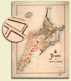
Portuguese Map, 1889
Published in Portugal by the Geographical Society of Lisbon two years after China recognized Portugal's claim to the city by treaty, this beautifully colored map shows the street pattern, important buildings, cemeteries, physical relief by shading and contour, and agricultural fields by various green patterns.
Planta da Peninsula de Macau.
(Lisboa: Sociedade de Geographia de Lisboa, 1889). G7823.M2 1889 .P5 TIL. |
|
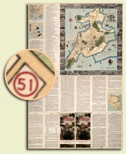
Tourist Map, 1936
Published in Macau, this map focuses on the city of Macau, naming streets in Portuguese and incorporating drawings of the major tourist sites at their actual locations. There are also photographs in the map border of the major tourist sites. There is extensive text on the verso describing the city's history, industry, commerce, and tourist sites.
Macau, Oldest Foreign Colony in Far East, Founded in 1557.
(Macau: Agência do Turismo, [1936]). G7823.M2E635 1936 .M3 TIL. |
|
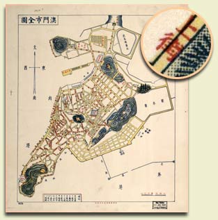
Chinese Street Map, 1952
This generalized street map identifies place names with Chinese characters.
"[City Plan of Macau (Ao-men)]."
Duplicate of Macau city plan in 1952-53, [Commercial and Industrial Yearbook] [s.n., 1953?]. G7823.M2G45 1953 .A5. |