
"Macau: Agência do Turismo, [1936],"
G7823.M2E635 1936 .M3 TIL
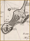
"Plan de la Ville et du Port de Macao,"
From Bellin,
Le Petit Atlas Maritime,
Tome lll, No. 57
(Paris, 1764).
G7823.M2 1764 .B38 TIL
"Die Chinesische Küste: der Provinz Kuang-tung, zu beiden Seiten des Meridians von Macao,"
From Heinrich Berghaus,
Atlas von Asia
(Gotha: Justus Perthes, 1832-43),
G7822.P4 1834 .B4
Now known as the Macau Special Administrative Region of the People's Republic of China, Macau consists of the city of Macau on a small peninsula of the Chinese mainland and the two small islands of Taipa and Colôane, which are connected by a causeway. The entire area of this administrative region is twenty-one square kilometers, which is about 0.1 the size of Washington, D.C. As of July 2001, Macau had an estimated population of about 454,000.
In recognition of the transfer of Macau from Portugal to China, the Library of Congress and the Instituto Cultural de Macau cosponsored a symposium, "Macau: A Cultural Dialogue toward a New Millennium," on September 21, 1999. The one-day symposium included a number of papers focusing on the cultural diversity and historical heritage of Macau itself, as well as presentations describing the resources in the Library of Congress pertaining to Macau. One of these presentations was a display of maps and atlases from the collections of the Geography and Map Division. The maps in this special presentation were selected from that display.
The Geography and Map Division collections contain a good representation of materials, both temporally and culturally, pertaining to the city and territory of Macau. These materials are both printed and manuscript maps, atlases, and views dating from 1655 to 1991. They represent an array of languages with a variety of map scales. There are maps of the city itself and the surrounding territory; there are also maps of the adjoining provinces–particularly Guangdong, and the coastline. One map is in Latin, although it was published by the Dutch. There are several French and British items, a German item, and a Russian item. Obviously, Chinese and Portuguese materials are also represented. From this variety, it is apparent that there has been a wide interest in Macau among Europeans during the last five centuries.
The selected items are arranged in chronological order, starting with materials pertaining to the seventeenth century and ending with materials documenting twentieth-century developments. By comparing these maps it is possible to determine how the city has changed over time, how the street pattern has evolved, how the harbor has developed, and how the planning of the city has been closely related to the physical landscape. There are also regional maps that will help the viewer appreciate the context in which Macau is located and has functioned. Its strategic location along the coast was an important factor, since the city served as a European port trading with a Chinese hinterland.
In 1996, the Library of Congress participated in the preparation of a fascinating exhibit, entitled "Space and Place, Mapmaking East and West: Four Hundred Years of Western and Chinese Cartography." It was organized by Cordell D. K. Yee, an instructor at St. John's College in Annapolis, Maryland. In this exhibit, Yee emphasized the idea of space and place by contrasting the Western (European) and Eastern mapping traditions. Almost all the maps that are displayed in this presentation represent the scientific approach of the European tradition. This Western mapping tradition is concerned with accurately measuring, mapping, and controlling space. Places are measured and described in terms of latitude and longitude.
The Eastern mapping tradition is characterized by the idea of place. It emphasizes idealizing or expressing the essence of a place–showing it pictorially and poetically. One map, an undated scroll map probably drawn in the late eighteenth century, represents the Chinese tradition. The scroll itself is approximately twenty-five feet long, although less than two feet need to be unrolled to show Macau and the adjacent coastline of China. That this map emphasizes the importance of Macau is obvious. The island is drawn out of proportion to its true geographical area. Buildings are drawn on the island, suggesting an image of urban activity in this port city. A textual notation warns that the "region is heavily infested with inner river bandits and sea pirates who can sail in and out freely. It also shares borders with Macau, where foreign boats and ships visit frequently. Those foreign vessels are always to be guarded against."
Pirates are dealt with in an atlas that is known as the Buccaneer Atlas. This manuscript atlas was compiled about 1690. It was prepared for and used by a noted British pirate by the name of Bartholomew Sharpe. Although the entire atlas covers the Indian Ocean coastline from southern Africa to Southeast Asia and the East Indies, only one page of the atlas is included here--the page delineating part of China's coastline in the vicinity of Macau.
By viewing this small selection of maps, it should be evident that the European influence was particularly strong in the mapping of Macau, reflecting a strong economic interest in the port city for more than four hundred years.