Tropical Cyclone Report
Tropical Storm Hanna
12 - 15 September 2002
Hanna was a poorly-organized tropical storm that nevertheless
produced rip currents responsible for three deaths off the beaches
of the Florida panhandle.
a. Synoptic History
Hanna formed in the Gulf of Mexico from a complex interaction of
a tropical wave, an upper-level low, and a surface trough. In the
days preceding genesis, a broad surface trough in the wake of
Hurricane Gustav
stretched from the western Atlantic across South
Florida and into the central Gulf of Mexico. During this time a
westward-moving tropical wave approached the Yucatan peninsula, and
when the wave reached the Gulf of Mexico on 10 September a weak
1008-mb low formed on the western end of the surface trough.
Initially, there was minimal convection associated with the
combination of these two features; however, on 11 September an
upper-level short-wave trough over the southern United States cut
off over the central Gulf of Mexico, and convection began to
develop to the east of the both the upper level low and the
tropical wave/surface low. The convection became sufficiently
organized to warrant a Dvorak classification at 1800 UTC that day,
and over the next 6 hours convection developed closer to the
surface low. Shortly before 0000 UTC 12 September a reconnaissance
aircraft was able to locate a well-defined low-level circulation
center, and with that the ninth depression of the season had formed
about 250 n mi south of Pensacola Florida.
The "best track" chart
of the tropical cyclone's path is given in Figure 1, with the wind
and pressure histories shown in Figure 2 and Figure 3,
respectively. The
best track positions and intensities are listed in Table 1. The
cyclone initially had some non-tropical characteristics, including
a westward tilt with height in association with the upper-low.
Despite strong southwesterly shear and a disorganized convective
structure, the depression became a tropical storm at 0600 UTC 12
September, about 225 n mi south of Pensacola. For the first 24
hours after genesis, the low-level circulation center rotated
counter-clockwise around the middle and upper-level centers, first
moving northeastward but turning to the southwest by late on 12
September. Moving slowly the following day, Hanna turned to the
west and then to the north ahead of an approaching mid-level
trough. Hanna strengthened and reached its peak intensity of 50 kt
and 1001 mb at 0000 UTC 14 September about 60 n mi south of the
mouth of the Mississippi River. In response to the approaching
trough, Hanna accelerated northward early on 14 September and its
exposed low-level circulation center began to become deformed and
elongated. With nearly all the significant weather well to its
east, Hanna's center of circulation passed over the extreme
southeastern tip of Louisiana near 0800 UTC. Hanna then turned to
the north-northeast and made its second landfall near the
Alabama-Mississippi border near 1500 UTC. Maximum winds at both
landfalls were near 50 kt. Hanna moved northeastward across
southern Alabama and weakened rapidly, dissipating by 1800 UTC 15
September. The remnants of the tropical cyclone then produced heavy
rains as they moved rapidly across Georgia and the
Carolinas.
b. Meteorological Statistics
Observations in Hanna (Figure 2 and Figure 3)
include satellite-based Dvorak technique intensity estimates from the
Tropical Analysis and Forecast Branch (TAFB), the Satellite
Analysis Branch (SAB) and the U. S. Air Force Weather Agency
(AFWA), as well as flight-level and dropwindsonde observations from
flights of the 53rd Weather Reconnaissance Squadron of
the U. S. Air Force Reserve Command. Selected surface observations
from land stations and data buoys are given in Table 2.
At 0600 UTC 12 September, buoy 42003 (at 25.9 N, 86.0
W, about 50 n mi south-southeast of the center) reported an 8-min
mean wind of 32 kt. This observation is the basis for the
assignment of tropical storm status at this time. Hanna's peak
winds are estimated to be 50 kt, based on surface-adjusted
flight-level winds of 46 kt at 2346 UTC 13 September and 47 kt at
1303 UTC 14 September, as well as a 47 kt 2-min wind from the
Pensacola ASOS station at 1352 UTC 14 September.
The only ship to report tropical storm force winds
was KRPP (Nobel Star), which reported winds of 37
kt and a pressure of 1006.0 mb at 0300 UTC 13 September, when it
was about 45 n mi west-southwest of the center. Other observations
of note include the aforementioned 47 kt report from Pensacola, the
strongest sustained wind observation from a surface station. The
highest gust reported was 59 kt at Pensacola Beach. An F0 tornado
that blew down some trees was reported in south Mobile County
Alabama. Gulfport Harbor reported a storm tide of 5.1 ft, and there
were other reports in the 3-5 ft range (Table 2). Minor river
flooding occurred along Spring Creek near Iron City, Georgia, where
the river crested at 15.3 ft, 1.3 feet above flood stage.
Hanna and its remnants produced heavy rains across
much of the southeastern states. These rains were largely confined
to the eastern semicircle of the storm, with numerous reports of
storm-total accumulations of between 5 and 10 inches. The highest
reported storm total, 15.56 in, was from Donalsonville,
Georgia.
c. Casualty and Damage Statistics
Three deaths are attributed to rip currents generated
by Hanna. An adult male (age 20) drowned in rough surf near
Pensacola Beach on the afternoon of the 14th. Two other
adult males (ages unknown) drowned, one at Seagrove Beach (Walton
County) on the 14th, and another at Panama City Beach on
the 15th.
Storm effects were relatively minor, and insured
losses did not meet the $25M threshold to be recorded by the
American Insurance Services Group. Minor beach erosion was reported
from Dauphin Island, Alabama, to Navarre Beach, Florida, as well as
in the Florida counties of Walton, Bay, and Gulf. Some storm tide
flooding was reported on Dauphin Island and in Mobile County.
Roughly 250 homes and 50 businesses were damaged from freshwater
flooding in Donalsonville, Georgia. Data from the Georgia Farm
Services Agency indicates agricultural damage, primarily to the
cotton and peanut crops, amounted to nearly $19 million. There were
several other apparently minor flooding events. Well after Hanna
had made landfall and weakened to a tropical depression, there was
a report of a roof being blown off a house in Donalsonville. Total
damage is estimated at $20 million.
d. Forecast and Warning Critique
Average official track errors (with the number of
cases in parentheses) for Hanna were 62 (8), 120 (6), 175 (4), and
225 (2), n mi for the 12, 24, 36, and 48 h forecasts, respectively.
These errors are roughly 50% larger than the average official track
errors for the 10-yr period 1992-2001 (43, 81, 115, and 148 n mi,
respectively [Table 3]). Official track forecasts issued from 0000
UTC 12 September through 0600 UTC 14 September are shown in
Figure 4.
The official forecasts consistently took Hanna northward to the
coast too quickly, as they failed to anticipate the westward track
of the storm prior to the 14th. Interestingly, much of
the model guidance did capture some of the early counter-clockwise
rotation of Hanna around the mid-level low; however, the official
forecasts remained, conservatively, on the right-side of the
guidance envelope showing a quicker motion toward the coast. Many
of the guidance models had mean errors lower than those of the
official forecast.
Official intensity forecasts correctly anticipated
that Hanna would not strengthen much. Average official intensity
errors were 2, 3, 4, and 13 kt for the 12, 24, 36, and 48 h
forecasts, respectively. For comparison, the average official
intensity errors over the 10-yr period 1992-2001 are 7, 11, 14, and
16 kt, respectively.
Table 4 lists the watches and warnings associated
with Hanna. A tropical storm watch was issued at 1500 UTC 12
September, 41 hours prior to the first landfall of Hanna in extreme
southeastern Louisiana. A tropical storm warning was issued at 0900
UTC 13 September, 23 hours prior to landfall. Tropical storm
conditions were confined to the area under warning.
Acknowledgments
The National Weather Service (NWS) Forecast Offices
in Mobile, New Orleans, and Tallahassee contributed surface
observations for this report. The best track of Hanna after
landfall is based in part on analyses from the NWS
Hydrometeorological Prediction Center.
Table 1: Best track for Tropical Storm Hanna, 12-15
September 2002.
Date/Time
(UTC) | Position | Pressure
(mb) | Wind Speed
(kt) | Stage |
Lat.
(°N) | Lon.
(°W) |
| 12 / 0000 | 26.3 | 86.6 | 1001 | 30 | tropical depression |
| 12 / 0600 | 26.7 | 86.4 | 1001 | 35 | tropical storm |
| 12 / 1200 | 27.0 | 86.7 | 1001 | 35 | " |
| 12 / 1800 | 27.1 | 87.5 | 1001 | 35 | " |
| 13 / 0000 | 26.7 | 88.0 | 1001 | 35 | " |
| 13 / 0600 | 26.9 | 88.8 | 1002 | 40 | " |
| 13 / 1200 | 27.4 | 89.3 | 1002 | 45 | " |
| 13 / 1800 | 27.7 | 89.3 | 1003 | 45 | " |
| 14 / 0000 | 28.0 | 89.2 | 1001 | 50 | " |
| 14 / 0600 | 28.7 | 89.1 | 1003 | 50 | " |
| 14 / 1200 | 30.0 | 88.8 | 1003 | 50 | " |
| 14 / 1800 | 30.8 | 88.0 | 1005 | 30 | tropical depression |
| 15 / 0000 | 31.5 | 87.0 | 1009 | 20 | " |
| 15 / 0600 | 32.0 | 86.0 | 1011 | 20 | " |
| 15 / 1200 | 33.0 | 85.0 | 1014 | 20 | " |
| 15 / 1800 | | | | | dissipated |
| 14 / 0000 | 28.0 | 89.2 | 1001 | 50 | minimum pressure/maximum wind |
| 14 / 0800 | 29.1 | 89.1 | 1003 | 50 | landfall near mouth of Mississippi River |
| 14 / 1500 | 30.4 | 88.4 | 1002 | 50 | landfall near AL/MS border |
Table 2: Selected
surface observations for Tropical Storm Hanna, 12-15 September
2002.
| | Minimum
Sea-level
Pressure | Maximum Surface Wind Speed
(kt) | |
| Location | Date/
Time
(UTC) | Press.
(mb) | Date/
Timea
(UTC) | Sust.
Windb
(kts) | Peak
Gust (kts) | Storm
Surgec
(ft) | Storm
Tided
(ft) | Rain
(storm total)
(in) |
| Buoys |
| 42003 (25.9N, 86.0W) | | | 13/0750 | 37 | | | | |
| 42007 (30.1N, 88.8W) | 14/1300 | 1003.5 | 14/1010 | 35 | 43 | | | |
| 42039 (28.8N, 86.1W) | | | 13/1700 | | 34 | | | |
| 42040 (29.2N, 88.2W) | 14/0900 | 1005.0 | 14/0720 | 33 | 41 | | | |
| CMAN stations |
| Dauphin Is (DPIA1) | 14/1400 | 1005 | 14/1230 | 41e | 50 | | 3.7 | |
| Cape San Blas (CSBF1) | 12/2300 | 1010.0 | 14/2040 | 33e | 43 | | | |
| SW Pass (BURL1) | 14/0600 | 1005.4 | 14/0250 | 27 | 31 | | | |
| Alabama |
| Belle Fontaine | | | | | | | | 5.75 |
| Mobile | 14/1556 | 1006 | 14/1047 | 25 | 30 | | | 1.31 |
| Coden (Co-op) | | | | | | | | 7.55 |
| Fairhope | | | | | | | | 2.12 |
| Florida |
| Bay County | | | | | | | 3 | |
| Chipley (Co-op) | | | | | | | | 9.67 |
| Crestview (Walker Elem.) | | | | | | | | 5.04 |
| Destin (DTS) | | | | | | | | 4.65 |
| Destin Middle School | | | | | | | | 5.41 |
| Eglin AFB (VPS) | | | 14/1857 | 32 | 41 | | | 2.77 |
| Eglin A-5 (Santa Rosa Is.) | 14/2038 | 1009.5 | 14/1556 | 35 | 48 | | | 3.45 |
| Hurlburt Field (HRT) | | | 14/1655 | 37 | 54 | | | 3.78 |
| Mariana | | | | | | | | 7.20 |
| Milligan | | | | | | | | 4.11 |
| Niceville (Co-op) | | | | | | | | 3.66 |
| Pensacola (PNS) | 14/1353 | 1007 | 14/1352 | 47 | 57 | | 3.4 | 3.05 |
| Pensacola Beach | | | 14/1430 | 43 | 59 | | | |
| Pensacola NAS (NPA) | | | 14/1437 | 41 | 48 | | | |
| Tallahassee | | | | | | | | 6.32 |
| Walton County | | | | | | | 4 | |
| Georgia |
| Blakely | | | | | | | | 7.65 |
| Donalsonville (Co-op) | | | | | | | | 15.56 |
| Leesburg (Co-op) | | | | | | | | 5.11 |
| Newton (Co-op) | | | | | | | | 7.00 |
| Louisiana |
| Bayou Dupre | | | | | | | 4.30 | |
| Boothville (BVE) | 14/0902 | 1005.1 | | | | | | 0.05 |
| Industrial Canal | | | | | | | 3.64 | |
| Mississippi |
| Gulfport Harbor | | | | | | | 5.1 | |
| Pascagoula (PQL) | 14/1354 | 1005.8 | | | | | | |
| Waveland | | | | | | | 4.78 | |
aDate/time is for wind gust when both sustained and gust are listed.
bExcept as noted, sustained wind averaging periods for C-MAN and land-based ASOS reports are
2 min; buoy averaging periods are 8 min.
cStorm surge is water height above normal astronomical tide level.
dStorm tide is water height above National Geodetic Vertical Datum (1929 mean sea level).
e10-min average. |
Table 3: Preliminary forecast evaluation
(heterogeneous sample) for Tropical Storm Hanna. Forecast errors
for tropical storm and hurricane stages (n mi) are followed by the
number of forecasts in parentheses. Errors smaller than the NHC
official forecast are shown in bold-face type.
| Forecast Technique | Period (hours) |
| 12 | 24 | 36 | 48 | 72 |
| CLP5 | 84 ( 8) | 150 ( 6) | 215 ( 4) | 325 ( 2) | |
| GFNI | 34 ( 5) | 52 ( 3) | 49 ( 1) | | |
| GFDI | 75 ( 8) | 133 ( 6) | 227 ( 4) | 409 ( 2) | |
| GFDL | 63 ( 8) | 108 ( 6) | 158 ( 4) | 356 ( 2) | |
| LBAR | 70 ( 8) | 120 ( 6) | 196 ( 4) | 370 ( 2) | |
| AVNI | 72 ( 8) | 111 ( 6) | 143 ( 4) | 204 ( 2) | |
| AVNO | 65 ( 8) | 111 ( 6) | 133 ( 4) | 188 ( 2) | |
| AEMI | 74 ( 4) | 105 ( 4) | 125 ( 3) | 114 ( 1) | |
| BAMD | 70 ( 8) | 122 ( 6) | 205 ( 4) | 342 ( 2) | |
| BAMM | 56 ( 8) | 84 ( 6) | 127 ( 4) | 183 ( 2) | |
| BAMS | 63 ( 8) | 101 ( 6) | 145 ( 4) | 212 ( 2) | |
| NGPI | 63 ( 8) | 100 ( 6) | 137 ( 4) | 165 ( 2) | |
| NGPS | 42 ( 8) | 68 ( 6) | 123 ( 4) | 135 ( 2) | |
| UKMI | 58 ( 7) | 99 ( 5) | 127 ( 3) | 159 ( 2) | |
| UKM | 51 ( 4) | 95 ( 3) | 146 ( 2) | 176 ( 1) | |
| A98E | 85 ( 8) | 130 ( 6) | 198 ( 4) | 318 ( 2) | |
| A9UK | 101 ( 4) | 141 ( 3) | 210 ( 2) | 280 ( 1) | |
| GUNS | 61 ( 7) | 105 ( 5) | 149 ( 3) | 243 ( 2) | |
| GUNA | 64 ( 7) | 106 ( 5) | 145 ( 3) | 232 ( 2) | |
| OFCL | 62 ( 8) | 120 ( 6) | 175 ( 4) | 225 ( 2) | |
| NHC Official(1992-2001 mean) | 43 (2199) | 81 (1965) | 115 (1759) | 148 (1580) | 222 (1272) |
| *Output from these models was unavailable at time of forecast issuance. |
Table 4: Watch and
warning summary for Tropical Storm Hanna, 12-15 September
2002.
| Date/Time | Action | Location |
| 12 / 1500 | Tropical Storm Watch issued | East of Pascagoula MS toSuwanee River FL |
| 13 / 0900 | Tropical Storm Warning issued | Grand Isle LA to Apalachicola FL |
| 14 / 0900 | Tropical Storm Watch
discontinued | East of Apalachicola to Suwanee
River |
| 14 / 1500 | Tropical Storm Warning
discontinued | Grand Isle to Pascagoula |
| 14 / 1800 | Tropical Storm Warning
discontinued | East of Pascagoula to
Apalachicola |
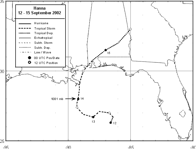
Figure 1:
Best track positions for Tropical Storm Hanna, 12-15 September 2002.
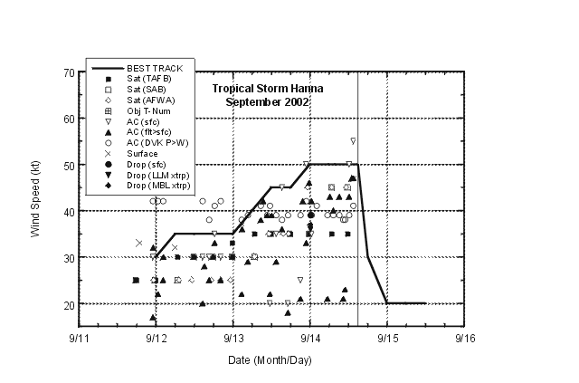
Figure 2:
Selected wind observations and best track
maximum sustained surface wind speed curve for Tropical Storm
Hanna, 12-15 September 2002. Aircraft observations have been
adjusted for elevation using 80%, 75%, and 80% reduction factors
for observations from 850 mb, 925 mb, and 1500 ft, respectively.
Dropwindsonde observations include actual 10 m winds (sfc), as well
as surface estimates derived from the mean wind over the lowest 150
m of the wind sounding (LLM), and from the sounding boundary layer
mean (MBL). Hanna's landfall near the Alabama-Mississippi border is
indicated by the solid vertical line.
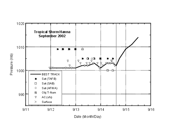
Figure 3:
Selected pressure observations and best
track minimum central pressure curve for Tropical Storm Hanna,
12-15 September 2002. Hanna's landfall near the Alabama-Mississippi
border is indicated by the solid vertical line.
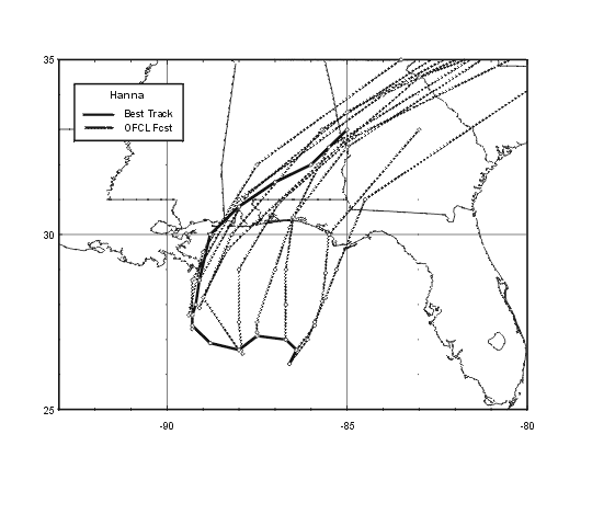
Figure 4:
Selected official track forecasts (dashed
lines, with 0, 12, 24, 36 ,48, and 72 h positions indicated) for
Tropical Storm Hanna, 12-15 September 2002. The best track is given
by the thick solid line with positions given at 6 h intervals.
|


