Tropical Cyclone Report
Tropical Storm Bertha
4 - 9 August 2002
Jack Beven
National Hurricane Center
20 November 2002
Bertha was a minimal tropical storm that made landfall in
southeastern Louisiana.
a. Synoptic History
Bertha had a non-tropical origin, forming from the same
non-tropical surface trough of low pressure that spawned Tropical
Storm Cristobal in the western North Atlantic Ocean. This trough
extended from the north central Gulf of Mexico across Florida into
the Atlantic on 1 August and moved little for the next two days. A
broad low pressure area was first noted on 3 August. Satellite,
surface, and radar observations indicated the low became better
organized just east of the mouth of the Mississippi River on 4
August, and the system developed into Tropical Depression Two
around 1800 UTC that day. The "best track" of the tropical
cyclone's path is shown in Figure 1, with the wind and pressure
histories shown in Figure 2 and Figure 3,
respectively. The best track
positions and intensities are listed in Table 1.
The depression strengthened further as it moved
west-northwestward. An Air Force Reserve Hurricane Hunter aircraft
indicated the system became Tropical Storm Bertha near 2300 UTC 4
August. The broad center made landfall near Boothville, LA about
two hours later. After landfall, Bertha assumed a wobbly
northwestward motion that took the center to the north of Lake
Ponchartrain later on the 5th. The cyclone weakened back
to a depression at 1200 UTC that day.
Bertha maintained its circulation over land while moving slowly
westward and then southward on 6 August. It began a southwestward
motion on the 7th, which brought the center back to the
Gulf of Mexico around 0900 UTC that day. This motion continued
until late on 8 August. While satellite and radar data showed
periods of increased organization, surface and aircraft
observations showed only slight strengthening at most over the
northwestern Gulf. The cyclone turned west-northwestward late on
the 8th, and this motion brought the center to the Texas
coast east of Kingsville around 0800 UTC 9 August. Bertha weakened
quickly after landfall and dissipated over southern Texas later
that day.
b. Meteorological Statistics
Observations in Bertha (Figure 2 and Figure 3)
include satellite-based
Dvorak technique intensity estimates from the Tropical Analysis and
Forecast Branch (TAFB), the Satellite Analysis Branch (SAB) and the
U. S. Air Force Weather Agency (AFWA), as well as flight-level
observations from flights of the 53rd Weather
Reconnaissance Squadron of the U. S. Air Force Reserve Command.
Tropical Depression Two was upgraded to Tropical Storm Bertha on
the basis of an aircraft report of 47 kt flight-level winds north
of the center at 850 mb. The highest surface winds measured during
the storm were at NOAA buoy 42007, which reported 33 kt 10-minute
average winds at 2240 UTC 4 August and 0310 UTC 5 August. The buoy
reported a peak gust of 43 kt at 0441 UTC on the 5th. A
nearby station run by Louisiana State University reported a 34 kt
wind gust at 0000 UTC on the 5th. The highest wind at a
coastal site was a gust of 36 kt at an National Ocean Service
station in Waveland, MS.
Storm tides reached as high as 3-4 ft -- 1-2 ft above normal
tide levels -- along portions of the Mississippi and southeastern
Louisiana coasts. Rainfall totals associated with Bertha were
mainly in the 3-6 inch range. There were locally heavier amounts,
including reports of 10.25 inches at Pascagoula, MS and Norwood,
LA. No tornadoes were reported in association with Bertha.
Selected surface observations from land stations and data buoys
are given in Table 2,
while storm-total rainfalls are summarized in
Table 3.
c. Casualty and Damage Statistics
Press reports indicate one death associated with Bertha - a
drowning in high surf at Perdido Key State Park, FL on 4
August.
Rains associated with Bertha produced areas of stream and street
flooding, which affected some structures producing minor damage. No
monetary damage figures are available.
d. Forecast and Warning Critique
Bertha was a tropical storm for only 12 h, so no meaningful
forecast verification statistics are available.
A tropical storm warning was issued at 2330 UTC 4 August for the
northern Gulf coast from Pascagoula, MS to the mouth of the
Mississippi River including Lake Borgne and Lake Ponchartrain. This
warning was issued 1.5 h before landfall as Bertha reached tropical
storm strength. The warning was discontinued at 1200 UTC 5 August
as Bertha weakened to a depression over land.
Acknowledgments
The National Weather Service WFO in Slidell, LA provided the
detailed rainfall data in this report.
Table 1: Best track for Tropical Storm Bertha, 4 - 9
August 2002
Date/Time
(UTC) | Position | Pressure
(mb) | Wind Speed
(kt) | Stage |
Lat.
(°N) | Lon.
(°W) |
| 04 / 1800 | 29.0 | 88.5 | 1012 | 25 | tropical depression |
| 05 / 0000 | 29.3 | 89.2 | 1008 | 35 | tropical storm |
| 05 / 0600 | 29.6 | 89.7 | 1008 | 35 | " |
| 05 / 1200 | 30.5 | 90.1 | 1010 | 25 | tropical depression |
| 05 / 1800 | 30.9 | 90.6 | 1011 | 20 | " |
| 06 / 0000 | 30.9 | 91.0 | 1012 | 15 | " |
| 06 / 0600 | 30.8 | 91.4 | 1013 | 15 | " |
| 06 / 1200 | 30.6 | 91.5 | 1013 | 15 | " |
| 06 / 1800 | 30.3 | 91.6 | 1012 | 15 | " |
| 07 / 0000 | 30.0 | 91.7 | 1010 | 20 | " |
| 07 / 0600 | 29.7 | 92.2 | 1011 | 20 | " |
| 07 / 1200 | 29.4 | 92.7 | 1011 | 25 | " |
| 07 / 1800 | 29.0 | 93.2 | 1010 | 25 | " |
| 08 / 0000 | 28.6 | 93.8 | 1010 | 25 | " |
| 08 / 0600 | 28.2 | 94.4 | 1010 | 25 | " |
| 08 / 1200 | 27.7 | 95.3 | 1011 | 20 | " |
| 08 / 1800 | 26.9 | 96.1 | 1011 | 20 | " |
| 09 / 0000 | 27.0 | 96.6 | 1011 | 20 | " |
| 09 / 0600 | 27.2 | 97.1 | 1011 | 20 | " |
| 09 / 1200 | 27.5 | 97.7 | 1012 | 20 | " |
| 09 / 1800 | | | | | dissipated |
| 05 / 0100 | 29.4 | 89.2 | 1007 | 35 | minimum pressure |
| 05 / 0200 | 29.4 | 89.3 | 1008 | 35 | landfall near Boothville, LA |
| 09 / 0800 | 27.3 | 97.4 | 1011 | 20 | landfall near Griffins Pt., TX |
Table 2: Selected surface observations for Tropical
Storm Bertha, 4 - 9 August 2002
| | Minimum
Sea-level
Pressure | Maximum Surface Wind Speed
(kt) | |
| Location | Date/
Time
(UTC) | Press.
(mb) | Date/
Timea
(UTC) | Sust.
Windb
(kts) | Peak
Gust (kts) | Storm
Surgec
(ft) | Storm
Tided
(ft) | Rain
(storm total)
(in) |
| Louisiana |
| Bayou Bievenue | | | | | | | 3.67 | |
| Bayou Dupre | | | | | | | 3.79 | |
| Industrial Canal | | | | | | | 3.17 | |
| Rigoletes | | | | | | | 2.56 | |
| | | | | | | | |
| Mississippi |
| Biloxi (KBIX) | | | | | | | | 1.97f |
| Biloxi | | | | | | | 1.75 | |
| Gulfport (KGPT) | | | | | | | | 2.12f |
| Gulfport | | | | | | | 4.00 | |
| Waveland (NOS) | | | 05/0800 | 27 | 36 | | 4.12 | |
| Offshore Stations |
| NOAA Buoy 42007 | | | 04/2240 | 33e | 43 | | | |
| LSU CSI-13 | 05/0400 | 1009.2 | 05/0000 | 29 | 34 | | | |
aDate/time is for wind gust when both sustained and gust are listed.
bExcept as noted, sustained wind averaging periods for C-MAN and land-based ASOS reports are
2 min; buoy averaging periods are 8 min.
cStorm surge is water height above normal astronomical tide level.
dStorm tide is water height above National Geodetic Vertical Datum (1929 mean sea level).
e10-min average.
f24 hr total. |
Table 3: Storm rainfalls (inches) for southeastern Louisiana
and southern Mississippi from Tropical Storm Bertha, 4-9 August
2002. "-" signifies missing data.
| Station | Aug 5 | Aug 6 | Aug 7 | Total |
| Louisiana |
| Amite | 0.01 | 1.29 | 0.12 | 1.42 |
| Angie | - | 4.04 | 0.12 | 4.16 |
| Baton Rouge (Arpt) | 0.01 | 0.23 | 0.00 | 0.24 |
| Bogalusa | 0.70 | 2.60 | 0.50 | 3.80 |
| Bush | 0.20 | 3.17 | 1.09 | 4.46 |
| Camp Covington | 0.09 | 1.89 | 0.24 | 2.22 |
| Clinton | 0.31 | 0.56 | 6.77 | 7.64 |
| Covington | - | 3.10 | Msg | 3.10 |
| Darlington | 0.00 | 0.11 | 2.28 | 2.39 |
| Franklinton#2 | 0.21 | 5.36 | 0.57 | 6.14 |
| Franklinton 5ssw | 0.10 | 7.49 | 0.91 | 8.50 |
| Grangeville | 0.01 | 0.02 | 4.85 | 4.88 |
| Houma | 0.00 | 0.94 | 0.00 | 0.94 |
| Jackson | - | 1.11 | 2.38 | 3.49 |
| Kentwood | 0.00 | 1.80 | 0.12 | 1.92 |
| Liverpool | 0.00 | 3.06 | 0.25 | 3.31 |
| N.O. Intl. Arpt. | 0.06 | 0.07 | 1.03 | 1.16 |
| N.O. Audubon Park | 0.03 | 0.17 | 0.00 | 0.20 |
| Norwood | - | 1.30 | 8.95 | 10.25 |
| Oaknolia | Msg | 0.56 | 3.10 | 3.66 |
| Olive Branch | - | 0.35 | 1.74 | 2.09 |
| Pearl River | 2.21 | 0.02 | 0.46 | 2.69 |
| Saint Francisville | - | - | 0.79 | 0.79 |
| Slidell (city) | 3.47 | 0.13 | 0.13 | 3.73 |
| Slidell, WFO | 1.79 | 0.21 | 0.52 | 2.52 |
| Slidell W-14 | 3.58 | 0.01 | 0.19 | 3.78 |
| Sun | - | 4.10 | 1.67 | 5.77 |
| Vacherie | 2.25 | 0.00 | 0.30 | 2.55 |
| Zachary | 0.00 | 0.00 | 1.10 | 1.10 |
| Mississippi |
| Bay St. Louis | - | 1.88 | 0.28 | 2.16 |
| Centerville | - | 1.15 | 1.33 | 2.48 |
| Graham Ferry | 3.28 | 0.41 | 0.00 | 3.69 |
| Gulfport (Navy) | - | 2.44 | 0.01 | 2.45 |
| Gulfport (Brentwood) | 1.94 | - | - | 1.94 |
| Gulfport (7W) | 1.20 | - | - | 1.20 |
| McComb | - | 4.48 | - | 4.48 |
| McComb (6SW) | - | 4.44 | - | 4.44 |
| Merril | 1.07 | 0.23 | 0.00 | 1.30 |
| N.W. Harrison County | 1.12 | 0.11 | 0.03 | 1.26 |
| N. E. Harrison County | 0.68 | 0.32 | 0.00 | 1.00 |
| Ocean Springs | - | 3.50 | - | 3.50 |
| Pascagoula | 6.90 | 2.65 | 0.70 | 10.25 |
| Picayune | 1.70 | 0.27 | 0.87 | 2.84 |
| Picayune (4NE) | 1.38 | - | - | 1.38 |
| Poplarville | 0.54 | 1.41 | 0.22 | 2.17 |
| Smithddale | - | 3.92 | - | 3.92 |
| Tylertown (2WNW) | - | 5.36 | 0.08 | 5.44 |
| Vancleve | - | - | 0.57 | 0.57 |
| Waveland | 2.65 | 0.15 | 0.17 | 2.97 |
| Wiggins | 0.65 | 0.61 | 0.04 | 1.30 |

Figure 1:
Best track positions and minimum pressure for
Tropical Storm Bertha, 4 - 9 August 2002.
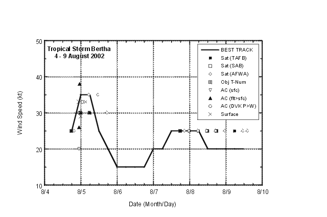
Figure 2:
Selected wind observations and best track
maximum sustained surface wind speed curve for Tropical Storm
Bertha, 4- 9 August 2002. Aircraft observations have been adjusted
for elevation using an 80% reduction factor for observations from
850 mb.
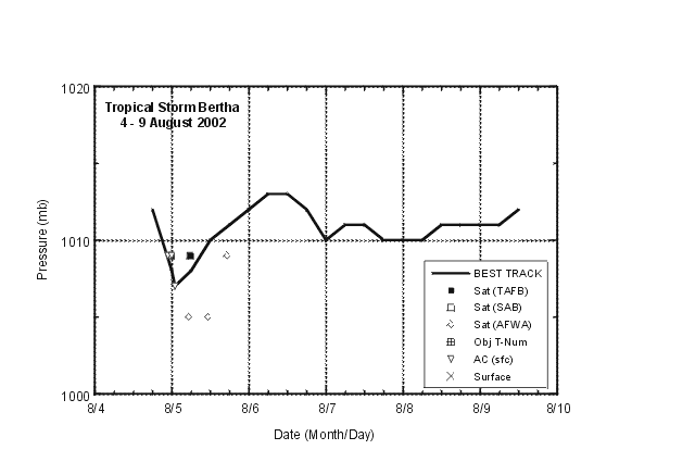
Figure 3:
Selected pressure observations and best
track minimum central pressure curve for Tropical Storm Bertha, 4 -
9 August 2002.
|


