Tropical Cyclone Report
Tropical Storm Cristobal
5 - 8 August 2002
James L. Franklin
National Hurricane Center
22 August 2002
Tropical Storm Cristobal was a relatively weak tropical cyclone
that meandered in the western Atlantic prior to being absorbed into
a frontal zone.
a. Synoptic History
The origin of Cristobal was non-tropical. On 1 August, a surface
trough of low pressure extended from the northern Gulf of Mexico
across Florida into the western North Atlantic Ocean. This trough
moved little over the next few days, spawning Tropical Storm Bertha
in the Gulf of Mexico on 4 August, while a second area of low
pressure was also developing within the trough near the South
Carolina coast. This second low moved slowly eastward and its
associated convection gradually became better organized; by 1800
UTC 5 August, when the low was about 150 n mi east-southeast of
Charleston, South Carolina, it had acquired sufficient organization
to be considered a tropical depression. The "best track" chart of
the tropical cyclone's path is given in Figure 1, with the wind and
pressure histories shown in Figure 2 and Figure 3,
respectively. The best
track positions and intensities are listed in Table 1.
The depression moved slowly south-southeastward over the next
day and a half. Development was limited by strong northerly wind
shear and a relatively dry environment, and most of the system's
convection was confined to the southern portion of the circulation.
The surface circulation became elongated in the southwesterly flow
in advance of a southward-moving cold front. Nevertheless, a
reconnaissance aircraft late on 6 August found that the central
pressure had fallen and that the depression had strengthened to a
tropical storm. On 7 August, Cristobal began a slow eastward motion
as it began to feel some influence of a large mid- to upper-level
trough moving off the U. S. east coast. The main convective
activity shifted from the south to the southeast, and then to the
east quadrant of the circulation by early on 8 August. This
reorganization of the convection was accompanied by a modest
increase in winds, to 45 kt, although there was apparently no
concurrent decrease in central pressure.
On 8 August, with additional dry air moving into the circulation
and convection becoming intermittent, Cristobal began a sudden
acceleration to the east-northeast, with its forward speed
increasing from roughly 3 to 20 kt over a 12 h interval. By 1800
UTC, reconnaissance aircraft reported some difficulty in closing a
low-level circulation as Cristobal was becoming absorbed into the
frontal zone, about 300 n mi southeast of Cape Hatteras, North
Carolina. Satellite imagery suggests that the circulation of
Cristobal had dissipated within the frontal zone by 0000 UTC 9
August.
b. Meteorological Statistics
Observations in Cristobal (Figure 2 and Figure 3)
include
satellite-based Dvorak technique intensity estimates from the
Tropical Analysis and Forecast Branch (TAFB), the Satellite
Analysis Branch (SAB) and the U. S. Air Force Weather Agency
(AFWA), as well as flight-level observations from flights of the
53rd Weather Reconnaissance Squadron of the U. S. Air
Force Reserve Command.
Ship reports of winds of tropical storm force associated with
Cristobal are given in Table 2.
A report from ship DGBE of 43 kt at
1800 6 August is not considered accurate (based on a history of
anomalously high wind reports) and is not included in the table.
There were no land-based observations of tropical storm force
winds. Cristobal was operationally upgraded to a tropical storm
based on a reconnaissance flight-level wind report of 48 kt from an
altitude of 6300 ft at 2249 UTC 6 August. The strongest
flight-level winds, 59 kt (from 1500 ft) were reported during
Cristobal's rapid acceleration on 8 August, just before the
circulation became lost within the frontal zone.
c. Casualty and Damage Statistics
There were no reports of damage or casualties associated with
Cristobal.
d. Forecast and Warning Critique
Official track forecasts (OFCL, Figure 4)
for Cristobal were poor,
to the point of being not skillful. Average OFCL errors (with the
number of cases in parentheses) for Cristobal were 62 (7), 136 (5),
322 (3), and 632 (1) n mi for the 12, 24, 36, and 48 h forecasts,
respectively. These errors are significantly larger than the
average OFCL errors for the 10-yr period 1992-2001(Table 3).
The poor official forecasts resulted from a reliance on global model
guidance, most notably the Aviation (AVNI), which consistently was
too early with the eastward acceleration of the tropical cyclone.
While the official forecasts and discussions did correctly conclude
that the Aviation model was over-forecasting the acceleration (OFCL
errors were considerably smaller than those of AVNI), the extent of
this error was not appreciated. The medium BAM (BAMM) performed
very well with Cristobal, although the reasons for this are not
clear. Part of the failure of models such as the Aviation, GFDL,
and UKMET can be attributed to failing to predict the initial
southward track of Cristobal, which took the cyclone farther from
the strong southwesterly flow ahead of the advancing mid- to
upper-level trough. During this period Cristobal was experiencing
northerly shear, and nearly all the significant convection was
south of the circulation center. One can speculate that some of the
southward motion was attributable to cyclone-scale non-advective
effects that might be poorly represented in the global models.
Average official intensity errors were 2, 5, 7, and 5 kt for the
12, 24, 36, and 48 h forecasts, respectively. For comparison, the
average official intensity errors over the 10-yr period 1992-2001
are 7, 11, 14, and 16 kt, respectively.
Table 1: Best track for Tropical Storm Cristobal, 5-8 August
2002.
Date/Time
(UTC) | Position | Pressure
(mb) | Wind Speed
(kt) | Stage |
Lat.
(°N) | Lon.
(°W) |
| 05 / 1800 | 32.0 | 77.2 | 1008 | 30 | tropical depression |
| 06 / 0000 | 31.5 | 77.1 | 1004 | 30 | " |
| 06 / 0600 | 31.1 | 77.0 | 1004 | 30 | " |
| 06 / 1200 | 30.7 | 76.6 | 1004 | 30 | " |
| 06 / 1800 | 30.4 | 76.4 | 1002 | 35 | tropical storm |
| 07 / 0000 | 30.1 | 76.2 | 999 | 40 | " |
| 07 / 0600 | 29.7 | 76.2 | 999 | 40 | " |
| 07 / 1200 | 29.4 | 76.0 | 999 | 40 | " |
| 07 / 1800 | 29.7 | 75.7 | 1000 | 40 | " |
| 08 / 0000 | 29.7 | 75.3 | 1000 | 45 | " |
| 08 / 0600 | 29.7 | 74.9 | 1000 | 45 | " |
| 08 / 1200 | 29.9 | 74.0 | 1003 | 45 | " |
| 08 / 1800 | 31.0 | 72.0 | 1008 | 45 | " |
| 09 / 0000 | | | | | absorbed intofrontal zone |
| 08 / 0000 - 1800 | | | 1000 - 1008 | 45 | maximum wind |
| 07 / 0000 - 1200 | | | 999 | 40 | minimum pressure |
Table 2: Selected ship reports with
winds of at least 34 kt for Tropical Storm Cristobal, 5-8 August
2002.
| Ship Name or Call Sign | Date/Time (UTC) | Lat.
(°N) | Lon.
(°W) | Wind dir/speed (deg/kt) | Pressure (mb) |
| KCKB | 7 / 0000 | 28.6 | 74.4 | 180/34 | 1010.1 |
| WUQL | 7 / 0900 | 28.5 | 74.9 | 220/34 | 1006.4 |
| WUQL | 7 / 1200 | 27.7 | 74.9 | 240/41 | 1009.5 |
|
Table 3: Preliminary forecast evaluation (heterogeneous sample)
for Tropical Storm Cristobal, 5-8 August 2002. Forecast errors for
tropical storm and hurricane stages (n mi) are followed by the
number of forecasts in parentheses. Errors smaller than the NHC
official forecast are shown in bold-face type. Models identified
with an asterisk are not available in time to meet forecast
deadlines.
| Forecast Technique | Period (hours) |
| 12 | 24 | 36 | 48 | 72 |
| CLP5 | 63 ( 7) | 93 ( 5) | 164 ( 3) | 175 ( 1) | |
| GFDI | 98 ( 7) | 249 ( 5) | 541 ( 3) | 776 ( 1) | |
| GFDL* | 74 ( 7) | 193 ( 5) | 387 ( 3) | 752 ( 1) | |
| GFNI | 44 ( 7) | 112 ( 5) | 348 ( 3) | 382 ( 1) | |
| LBAR | 44 ( 7) | 76 ( 5) | 206 ( 3) | 377 ( 1) | |
| AVNI | 141 ( 6) | 311 ( 5) | 452 ( 3) | 533 ( 1) | |
| AVNO* | 81 ( 7) | 250 ( 4) | 486 ( 2) | | |
| BAMD | 57 ( 7) | 87 ( 5) | 161 ( 3) | 234 ( 1) | |
| BAMM | 40 ( 7) | 59 ( 5) | 159 ( 3) | 164 ( 1) | |
| BAMS | 53 ( 7) | 95 ( 5) | 188 ( 3) | 277 ( 1) | |
| NGPI | 60 ( 7) | 145 ( 5) | 309 ( 3) | 505 ( 1) | |
| NGPS* | 61 ( 7) | 117 ( 5) | 241 ( 3) | 439 ( 1) | |
| UKMI | 47 ( 7) | 142 ( 5) | 365 ( 3) | 635 ( 1) | |
| UKM* | 29 ( 3) | 65 ( 2) | 316 ( 1) | | |
| A98E | 61 ( 7) | 81 ( 5) | 107 ( 3) | 117 ( 1) | |
| A9UK | 58 ( 3) | 54 ( 2) | 94 ( 1) | | |
| GUNS | 67 ( 7) | 178 ( 5) | 406 ( 3) | 633 ( 1) | |
| GUNA | 88 ( 6) | 211 ( 5) | 416 ( 3) | 597 ( 1) | |
| OFCL | 62 ( 7) | 136 ( 5) | 322 ( 3) | 632 ( 1) | |
| NHC Official (1992-2001 mean) | 43 (2199) | 81 (1965) | 115 (1759) | 148 (1580) | 222 (1272) |
| *Output from these models was unavailable at time of forecast issuance. |
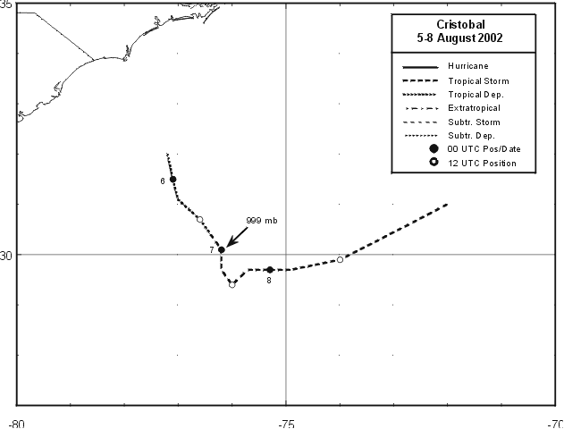
Figure 1:
Best track positions for Tropical Storm Cristobal, 5-8
August 2002.
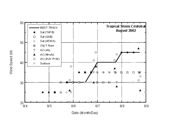
Figure 2:
Selected wind observations and best track maximum sustained
surface wind speed curve for Tropical Storm Cristobal, 5-8 August 2002.
Aircraft observations have been adjusted for elevation using 90%, 80%, and
80% reduction factors for observations from 700 mb, 850 mb, and 1500 ft,
respectively.
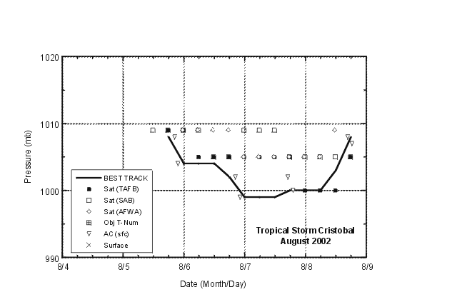
Figure 3:
Selected pressure observations and best track minimum
central pressure curve for Tropical Storm Cristobal, 5-8 August 2002.
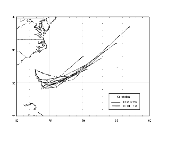
Figure 4:
Official track forecasts (dashed lines, with 0, 12, 24, 36,
48, and 72 h positions indicated) for Tropical Storm Cristobal, 5-8 August
2002 (including depression stage, but excluding forecasts verifying after
Cristobal was absorbed). The best track is given by the thick solid line
with positions given at 6 h intervals.
|


