Tropical Cyclone Report
Hurricane Gustav
8 - 12 September 2002
Jack Beven
National Hurricane Center
14 January 2003
Hurricane Gustav was a category 2 hurricane of subtropical
origin. The cyclone passed near the Outer Banks of North Carolina
as a tropical storm, then passed over the eastern end of Nova
Scotia and western Newfoundland as a category 1 hurricane.
a. Synoptic History
An area of showers developed between the Bahamas and Bermuda on
6 September in association with a developing upper-level trough and
a weak surface trough. The upper-level trough amplified over the
next two days in response to upstream ridging enhanced by Tropical
Storm Fay over the Gulf of Mexico. As this occurred, convection
increased in both coverage and intensity and the surface trough
became better defined. A broad surface low formed in the system
late on 7 September. By 1200 UTC 8 September, the cyclone had
developed sufficient organized convection to qualify as a
subtropical depression about 440 n mi south-southeast of Cape
Hatteras, North Carolina. Later that day, an Air Force Reserve
Hurricane Hunter aircraft investigated the cyclone and found it had
become Subtropical Storm Gustav. The "best track" chart of the
tropical cyclone's path is given in Figure 1, with the wind and
pressure histories shown in Figure 2 and Figure 3,
respectively. The best
track positions and intensities are listed in Table 1.
Gustav moved erratically west-northwestward on 9 September as it
slowly strengthened. On that day, the cyclone had a large area of
light winds near the center with multiple low-level cloud swirls,
and aircraft and satellite position fixes often differed by 30-50 n
mi. Gustav turned north early on 10 September as convection became
better organized near the center. Based on this and the development
of a band of strong winds closer to the center, it is estimated
that the cyclone transformed into a tropical storm around 1200 UTC.
Maximum sustained winds reached 55 kt while the center passed
between Cape Hatteras and Diamond Shoals, North Carolina about 2100
UTC that day. It should be noted that while the circulation center
stayed offshore (not a "landfall"), the radius of maximum winds
(RMW) passed over portions of the Outer Banks and thus counts as a
"strike" for this area.
Gustav turned northeastward when it reached the Hatteras area,
then accelerated northeastward on 11 September in southwesterly
flow caused by baroclinic cyclogenesis over the New England states
and southeastern Canada. In a complex process similar to that seen
in Hurricane Michael in 2000, the tropical cyclone intensified as
it gradually began to merge with or absorb the non-tropical low.
Gustav became the 2002 season's first hurricane just before 1200 UTC
and reached a maximum intensity of 85 kt near 1800 UTC. After that,
the cyclone began to weaken. Gustav made landfall over the southern
part of Cape Breton, Nova Scotia near 0430 UTC 12 September as an
80-kt hurricane. Satellite, surface, and radar data indicated the
cyclone was becoming extratropical as it made a second landfall
over southwestern Newfoundland near 0900 UTC. Gustav lost all
tropical characteristics by 1200 UTC as it continued northeastward
while decelerating across Newfoundland. The remnant extratropical
low moved into the Labrador Sea, where it turned northwestward late
on 13 September and dissipated on 15 September.
b. Meteorological Statistics
Observations in Gustav (Figure 2 and Figure 3)
include satellite-based
Dvorak technique intensity estimates from the Tropical Analysis and
Forecast Branch (TAFB), the Satellite Analysis Branch (SAB) and the
U. S. Air Force Weather Agency (AFWA), as well as flight-level and
dropwindsonde observations from flights of the 53rd
Weather Reconnaissance Squadron of the U. S. Air Force Reserve
Command. Additionally, there were many observations from ships,
buoys, and land stations.
The maximum winds reported in Gustav were flight-level winds of
104 kt from both Air Force Reserve (at 850 mb) and NOAA (at 700 mb)
hurricane hunters around 1900-2000 UTC 11 September. Using standard
flight-level to surface reduction for eyewall conditions, the NOAA
report would yield a surface wind estimate of 90-95 kt (Figure 2).
However, neither aircraft reported an eye or eyewall, so a more
conservative reduction for convective bands would yield a surface
wind estimate of 85-90 kt. This is in better agreement with the
80-85 kt estimated surface wind from the Air Force aircraft and
with an 83 kt surface wind measured by the Stepped Frequency
Microwave Radiometer instrument on the NOAA aircraft. The minimum
aircraft-reported pressure on a formal fix was 969 mb at 1701 UTC
11 September. However, a dropsonde released later that day near the
flight-level wind maximum southeast of the center reported a
surface pressure of 964 mb. This suggests that the rapid
northeastward motion displaced the wind center of the cyclone to
the northwest of the pressure center.
Gustav affected many ships and buoys between North Carolina and
Nova Scotia, with selected observations given in Table 2.
The most notable observations were from the ship Tellus
(call sign WRYG), which reported 88 kt and 90 kt winds at 1500 and
1600 UTC 11 September. While these winds are not totally
inconsistent with the strength of Gustav at the time, the ship was
far enough from the center that the speeds appear somewhat suspect.
The oil rig WCY533 near Sable Island reported 74 kt winds and a
965.0 mb pressure at 0300 UTC 12 September. Other noteworthy ship
and buoy reports include a 55 kt wind reported by the
Columbus Canterbury (call sign ELUB8) near the North
Carolina coast at 1900 UTC 10 September and a 964.3 mb pressure
from Canadian buoy 44142 at 2300 UTC 11 September.
Gustav brought tropical-storm winds to portions of the North
Carolina coast and eastern Nova Scotia. In North Carolina, the
Coastal Marine Automated Network station at Diamond Shoals reported
52 kt sustained winds with a gust to 61 kt at 1400 UTC 10 September
and a 984.8 mb pressure at 2000 UTC. The Cape Hatteras Coast Guard
station reported a gust of 68 kt at 2130 UTC. In Nova Scotia, Sable
Island reported 48 kt sustained winds with a gust to 66 kt at 0414
UTC 12 September, while Hart Island reported a pressure of 961.4 mb
at 0345 UTC. Tropical-storm winds were also reported on Prince
Edward Island as the wind field of Gustav expanded during
extratropical transition.
Storm surge flooding of 5-6 ft above normal tide levels occurred
along the inland side of the Outer Banks in Hyde and Dare counties.
This occurred during a period of strong northwesterly winds
following the passage of the center of Gustav. Storm tides of 3-4
ft above normal were reported in Cedar Island and along the Neuse
River. Tides were 1-2 ft above normal elsewhere along the coasts of
North Carolina and southeastern Virginia. A 4-5 ft storm surge
occurred at Charlottetown, Prince Edward Island. Above normal tides
were also reported along the coasts of northern and eastern Nova
Scotia and eastern New Brunswick.
Storm total rainfalls were 2-5 in over portions of the Outer
Banks, Nova Scotia, and Prince Edward Island. This included a 4.90
in total at Ocracoke, North Carolina and a 4.25 in total at Lyon's
Brook, Nova Scotia. One tornado occurred during Gustav near
Ocracoke.
c. Casualty and Damage Statistics
Gustav directly caused one death - a swimmer at Myrtle Beach,
South Carolina who suffered injuries from high surf and died two
days later. Forty people had to be rescued from storm surge in
Hatteras at the height of the storm.
Damages from Gustav were minor. Damages to property and vehicles
in North Carolina is estimated at about $100,000. In Canada, the
worst damage occurred on Prince Edward Island, where whole trees
were toppled and local flooding occurred. In Nova Scotia, some
docks were damaged and trees were blown down.
d. Forecast and Warning Critique
Average official track errors (with the number of cases in
parentheses) for Gustav were 50 (13), 70 (11), 66 (9), 112 (7), and
239 (3) n mi for the 12, 24, 36, 48, and 72 h forecasts,
respectively. These errors are lower than the average official
track errors for the 10-yr period 1992-2001 (43, 81, 115, 148, and
222 n mi, respectively) for 24, 36, and 48h, and higher than the
10-yr average at 12 and 72 h. (link table="4"/>).
Several of the numerical guidance models performed well during
Gustav. The National Weather Service Global Forecasting System
model (AVNO) had overall best performance, with average track
forecast errors of less than 60 n mi through 48 h and a 110 n mi
error at 72 h.
Average official intensity errors were 5, 7, 9, 12, and 22 kt
for the 12, 24, 36, 48, and 72 h forecasts, respectively. For
comparison, the average official intensity errors over the 10-yr
period 1992-2001 are 7, 11, 14, 16, and 19 kt, respectively. The
largest intensity forecast errors occurred during Gustav's
northeastward acceleration, when the intensities were
underforecast.
Table 5 lists the U. S. watches and warnings associated with
Gustav. A tropical storm watch was issued for portions of the North
Carolina coast at 2100 UTC 8 September, while a tropical storm
warning was issued for much of the watch area at 0300 UTC 9
September. This was 48 and 42 h, respectively, before the closest
approach of the center to the Cape Hatteras area. In addition to
the warnings in Table 5, the Canadian Hurricane Center in Halifax,
Nova Scotia issued warnings for wind rain and storm surge for large
portions of New Brunswick, Nova Scotia, Newfoundland, and Prince
Edward Island.
Acknowledgments
Much of the U. S. data in this report was contributed by the
National Weather Service forecast offices in Wilmington, North
Carolina, Morehead City, North Carolina, and Wakefield, Virginia.
Peter Bowyer of the Canadian Hurricane Center and Chris Fogarty of
Dalhouse University contributed much of the Canadian data.
Table 1: Best track for Hurricane Gustav, 8 - 12
September 2002.
Date/Time
(UTC) | Position | Pressure
(mb) | Wind Speed
(kt) | Stage |
Lat.
(°N) | Lon.
(°W) |
| 08/ 1200 | 29.0 | 71.0 | 1009 | 30 | subtropical depression |
| 08 / 1800 | 30.2 | 71.1 | 1007 | 35 | subtropical storm |
| 09 / 0000 | 30.5 | 72.3 | 1004 | 40 | " |
| 09 / 0600 | 31.2 | 72.6 | 1003 | 40 | " |
| 09 / 1200 | 31.6 | 73.6 | 1002 | 40 | " |
| 09 / 1800 | 31.9 | 74.5 | 1002 | 40 | " |
| 10 / 0000 | 32.1 | 75.5 | 996 | 45 | " |
| 10 / 0600 | 33.0 | 75.5 | 990 | 50 | " |
| 10 / 1200 | 33.7 | 75.4 | 987 | 50 | tropical storm |
| 10 / 1800 | 35.0 | 75.4 | 985 | 55 | " |
| 11 / 0000 | 35.5 | 74.7 | 983 | 55 | " |
| 11 / 0600 | 36.8 | 73.0 | 977 | 60 | " |
| 11 / 1200 | 38.0 | 70.8 | 971 | 70 | hurricane |
| 11 / 1800 | 40.3 | 66.8 | 964 | 85 | " |
| 12 / 0000 | 43.1 | 62.8 | 962 | 80 | " |
| 12 / 0600 | 46.5 | 59.6 | 960 | 75 | " |
| 12 / 1200 | 48.6 | 57.7 | 965 | 60 | extratropical |
| 12 / 1800 | 50.1 | 55.5 | 967 | 60 | " |
| 13 / 0000 | 51.0 | 54.0 | 968 | 55 | " |
| 13 / 0600 | 52.5 | 52.5 | 968 | 50 | " |
| 13 / 1200 | 54.5 | 51.4 | 972 | 45 | " |
| 13 / 1800 | 56.0 | 49.5 | 976 | 45 | " |
| 14 / 0000 | 57.0 | 51.5 | 982 | 40 | " |
| 14 / 0600 | 58.0 | 52.5 | 984 | 35 | " |
| 14 / 1200 | 59.5 | 53.5 | 989 | 30 | " |
| 14 / 1800 | 61.0 | 54.0 | 992 | 30 | " |
| 15 / 0000 | 62.5 | 54.5 | 998 | 20 | " |
| 15 / 0600 | | | | | dissipated |
| 12 / 0400 | 45.3 | 60.8 | 960 | 80 | minimum pressure |
| 12 / 0430 | 45.6 | 60.4 | 960 | 80 | Landfall near Kelpy Cove, Cape Breton Island, Nova Scotia |
| 12 / 0900 | 47.6 | 58.6 | 963 | 65 | Landfall near Rose-Blanche-Harbour le Cou, Newfoundland |
Table 2: Selected ship and drifting buoy
reports with winds of at least 34 kt for Hurricane Gustav, 8 -12
September 2002.
| Ship Name or Call Sign | Date/Time (UTC) | Lat.
(°N) | Lon.
(°W) | Wind dir/speed (deg/kt) | Pressure (mb) |
| Buoy 41652 | 08 / 1620 | 30.0 | 68.8 | 150 / 43 | 1012.9 |
| Buoy 41537 | 09 / 0300 | 27.4 | 70.8 | 210 / 41 | 1015.4 |
| Buoy 41652 | 09 / 0620 | 30.0 | 68.4 | 170 / 52 | 1014.6 |
| Buoy 41537 | 09 / 0800 | 27.5 | 70.8 | 180 / 56 | 1014.6 |
| P&O Nedlloyd Sydney | 09 / 1500 | 34.0 | 76.2 | 010 / 45 | 1010.5 |
| P&O Nedlloyd Sydney | 09 / 1800 | 34.6 | 75.2 | 030 / 37 | 1007.5 |
| Star Inventana | 10 / 1800 | 32.6 | 72.3 | 250 / 35 | 1012.4 |
| Charles
Island | 10 / 1800 | 33.9 | 72.8 | 140 / 35 | 1003.0 |
| Columbus
Canterbury | 10 / 1900 | 35.5 | 75.0 | 090 / 55 | N/A |
| Charles Island | 11 / 0000 | 33.0 | 74.1 | 250 / 40 | 1001.5 |
| WAAH | 11 / 0600 | 35.8 | 72.5 | 220 / 52 | 988.5 |
| Nedlloyd Holland | 11 / 1500 | 37.8 | 66.9 | 210 / 54 | 990.5 |
| Tellus | 11 / 1500 | 38.0 | 68.1 | 150 / 88 | 978.0 |
| Tellus | 11 / 1600 | 38.0 | 68.2 | 240 / 90 | 982.3 |
| Swan | 11 / 1800 | 35.0 | 71.5 | 240 / 39 | 1003.7 |
| P&O Nedlloyd Jakarta | 12 / 0000 | 37.2 | 59.8 | 220 / 47 | 1005.0 |
| Majestic Maersk | 12 / 0000 | 40.7 | 61.6 | 220 / 40 | 988.0 |
| WCY533 | 12 / 0300 | 44.0 | 60.3 | 190 / 74 | 965.0 |
| Choyang Zenith | 12 / 0600 | 37.0 | 59.9 | 230 / 41 | 1004.5 |
| YJRX2 | 12 / 0600 | 44.2 | 59.6 | 240 / 55 | 978.7 |
| Albatros | 12 / 1200 | 44.1 | 63.8 | 320 / 48 | 993.2 |
| Algofax | 12 / 1200 | 46.6 | 59.5 | 290 / 43 | 976.0 |
| 3FPK7 | 12 / 1200 | 46.6 | 48.0 | 210 / 38 | 995.6 |
| HP6038 | 12 / 1500 | 46.4 | 48.4 | 190 / 40 | 994.7 |
| Kometik | 12 / 1800 | 43.4 | 53.9 | 230 / 55 | 992.0 |
| Atlantic Concert | 12 / 1800 | 46.3 | 50.2 | 160 / 36 | 990.9 |
| Buoy 44602 | 12 / 2100 | 44.5 | 52.8 | 250 / 39 | N/A |
| HP6038 | 13 / 0300 | 46.4 | 48.4 | 230 / 45 | 999.5 |
| Atlantic Concert | 13 / 0600 | 45.6 | 53.4 | 260 / 50 | 1004.2 |
| 3FPK7 | 13 / 0900 | 46.6 | 48.0 | 250 / 39 | 1005.7 |
| Canmar Success | 13 / 1200 | 49.7 | 45.7 | 200 / 42 | 1002.5 |
| Canmar Success | 13 / 1800 | 50.0 | 47.4 | 210 / 45 | 1005.8 |
|
Table 3: Selected surface
observations for Hurricane Gustav, 8-12 September 2002.
| | Minimum
Sea-level
Pressure | Maximum Surface Wind Speed
(kt) | |
| Location | Date/
Time
(UTC) | Press.
(mb) | Date/
Timea
(UTC) | Sust.
Windb
(kts) | Peak
Gust (kts) | Storm
Surgec
(ft) | Storm
Tided
(ft) | Rain
(storm total)
(in) |
| North Carolina |
| Alligator River Bridge | | | 10/2100 | | 56 | | | |
| Beaufort (KMRH)f | 10/1900 | 999.7 | 10/2033 | 32 | 39 | | | 1.95 |
| Cape Hatteras CG | | | 10/2130 | | 68 | | | |
| Cape Hatteras Fishing Pier | 10/2112 | 985.3 | 10/2112 | 37 | 55 | | | |
| Cedar Island | | | 10/2130 | | 48 | | | |
| Duck (NOS) | 10/2324 | 995.0 | 10/2248 | 44 | 55 | | | |
| Elizabeth City (KECG) | 10/2145 | 999.0 | 10/2054 | 26 | 38 | | | 0.61 |
| Frisco (KSHE) | 10/1700 | 987.5 | 11/0100 | 25 | 36 | | | 4.72 |
| Manteo (KMQI)f | 10/2100 | 993.5 | 10/2300 | 35 | 47 | | | 2.27 |
| Nags Head | | | 10/2000 | | 53 | | | |
| Ocracoke | | | 10/2030 | | 64 | | | 4.90 |
| Nova Scotia |
| Ashdale | | | | | | | | 4.13 |
| Hallifax | | | | | | | | 3.70 |
| Hart Island (CWRN) | 12/0345 | 961.4 | | | | | | |
| Liverpool | | | | | | | | 4.02 |
| Lyon's Brook | | | | | | | | 4.25 |
| Middleboro | | | | | | | | 3.94 |
| Sable Island (CWSA)f | 12/0300 | 969.2 | 12/0414 | 48 | 66 | | | |
| St. Paul's Island (CWEF)f | 12/0500 | 961.6 | 12/0742 | | 66 | | | |
| Prince Edward Island | | | | | | | | |
| Charlottetown | | | 12/0245 | 35 | 52 | 4-5 | | 2.76 |
| Buoys and C-MAN |
| Buoy 41001 | 11/0600 | 997.5 | 11/0310 | 36e | 46 | | | |
| Buoy 41002 | 10/0500 | 996.7 | 10/1500 | 29 | 35 | | | |
| Buoy 44004 | 11/1300 | 977.5 | 10/1420 | 44e | 62 | | | |
| Buoy 44008 | 11/1700 | 983.1 | 11/1600 | 29 | 35 | | | |
| Buoy 44011 | 11/1900 | 972.4 | 11/2000 | 44 | 61 | | | |
| Buoy 44014 | 11/0400 | 991.3 | 11/0500 | 35 | 44 | | | |
| Buoy 44137 | 12/0000 | 983.6 | 12/0500 | 47 | | | | |
| Buoy 44139 | 12/0500 | 982.8 | 12/0600 | 41 | | | | |
| Buoy 44142 | 11/2300 | 964.3 | 12/0000 | 44 | 60 | | | |
| Buoy 44145f | 12/0900 | 994.8 | 13/0000 | 52 | | | | |
| Bouy 44251 | 12/1000 | 984.7 | 13/0000 | 37 | | | | |
| Buoy 44255 | 12/0800 | 968.1 | 13/0700 | 37 | | | | |
| Cape Lookout (CKLN7) | 10/1700 | 996.9 | 10/2010 | 31e | 40 | | | |
| Diamond Shoals (DSLN7) | 10/2000 | 984.8 | 10/1400 | 52 | 61 | | | |
| Duck (DUCN7) | 11/0000 | 997.7 | 10/2250 | 46e | 57 | | | |
| Frying Pan Shoals (FPSN7) | 10/1000 | 1002.1 | 10/0100 | 44 | 52 | | | |
aDate/time is for wind gust when both sustained and gust are listed.
bExcept as noted, sustained wind averaging periods for C-MAN and land-based ASOS reports are
2 min; buoy averaging periods are 8 min.
cStorm surge is water height above normal astronomical tide level.
dStorm tide is water height above National Geodetic Vertical Datum (1929 mean sea level).
e10-min average
fIncomplete record |
Table 4: Preliminary forecast evaluation (heterogeneous sample)
for Hurricane Gustav, 8 - 12 September 2002. Forecast errors for
tropical storm and hurricane stages (n mi) are followed by the
number of forecasts in parentheses. Errors smaller than the NHC
official forecast are shown in bold-face type.
| Forecast Technique | Period (hours) |
| 12 | 24 | 36 | 48 | 72 |
| CLP5 | 88 (13) | 202 (11) | 301 ( 9) | 421 ( 7) | 421 ( 3) |
| GFNI | 68 (12) | 106 (10) | 188 ( 8) | 338 ( 6) | 822 ( 2) |
| GFDN* | 62 ( 7) | 103 ( 6) | 141 ( 5) | 229 ( 4) | 725 ( 2) |
| GFDI | 74 (13) | 82 (11) | 121 ( 9) | 167 ( 7) | 422 ( 3) |
| GFDL* | 53 (13) | 88 (11) | 104 ( 9) | 161 ( 7) | 348 ( 3) |
| AFW1* | 57 ( 6) | 104 ( 5) | 136 ( 4) | 213 ( 3) | 404 ( 1) |
| COAI | 65 (11) | 94 ( 9) | 163 ( 7) | 293 ( 5) | 887 ( 1) |
| COAL* | 68 ( 6) | 84 ( 5) | 116 ( 4) | 215 ( 3) | 729 ( 1) |
| LBAR | 60 (13) | 121 (11) | 203 ( 9) | 309 ( 7) | 411 ( 3) |
| A98E | 67 (13) | 91 (11) | 79 ( 9) | 168 ( 7) | 147 ( 3) |
| A9UK | 70 ( 6) | 68 ( 5) | 84 ( 4) | 200 ( 3) | 104 ( 1) |
| BAMD | 50 (13) | 75 (11) | 99 ( 9) | 126 ( 7) | 197 ( 3) |
| BAMM | 55 (13) | 90 (11) | 121 ( 9) | 146 ( 7) | 263 ( 3) |
| BAMS | 69 (13) | 113 (11) | 157 ( 9) | 183 ( 7) | 372 ( 3) |
| AVNI | 42 (13) | 46 (11) | 55 ( 9) | 65 ( 7) | 134 ( 3) |
| AVNO* | 29 (13) | 32 (11) | 42 ( 9) | 58 ( 7) | 110 ( 2) |
| AEMI | 53 ( 9) | 61 ( 7) | 78 ( 6) | 92 ( 4) | 232 ( 2) |
| AEMN* | 32 ( 6) | 45 ( 5) | 43 ( 4) | 63 ( 3) | 187 ( 1) |
| NGPI | 81 (13) | 66 (11) | 109 ( 9) | 155 ( 7) | 307 ( 3) |
| NGPS* | 40 (13) | 61 (11) | 78 ( 9) | 124 ( 7) | 402 ( 3) |
| UKMI | 51 (12) | 61 (10) | 65 ( 8) | 80 ( 6) | 115 ( 3) |
| UKM* | 68 ( 6) | 58 ( 5) | 74 ( 4) | 100 ( 3) | 98 ( 1) |
| GUNS | 63 (12) | 65 (10) | 78 ( 8) | 95 ( 6) | 138 ( 3) |
| GUNA | 55 (12) | 58 (10) | 67 ( 8) | 80 ( 6) | 133 ( 3) |
| OFCL | 50 (13) | 70 (11) | 66 ( 9) | 112 ( 7) | 239 ( 3) |
| NHC Official (1992-2001 mean) | 43 (2199) | 81 (1965) | 115 (1759) | 148 (1580) | 222 (1272) |
| *Output from these models was unavailable at time of forecast issuance. |
Table 5: Watch and warning summary for Hurricane
Gustav. The table does not include the various watches and warning
issued for Canada by Environment Canada.
| Date/Time | Action | Location |
| 08/2100 | Tropical Storm Watch | Cape Fear, NC northward to the NC/VA border
including the Pamlico and Ablemarle Sounds |
| 09/0300 | Tropical Storm Warning | Cape Fear, NC to Currituck Beach Light, NC
including the Pamlico and Ablemarle Sounds |
| 09/0300 | Tropical Storm Watch | NC/VA border to Parramore Island, VA and southern Chesapeake
Bay south of New Point Comfort, VA |
| 10/0300 | Tropical Storm Warning | Currituck Beach Light, NC to Parramore Island, VA and southern
Chesapeake Bay south of New Point Comfort, VA |
| 10/1800 | Tropical Storm Warning discontinued | west of Surf City, NC |
| 10/2100 | Tropical Storm Warning discontinued | west of Bogue Inlet, NC |
| 11/0300 | Tropical Storm Warning discontinued | south of Ocracoke Inlet, NC including the Pamlico and Ablemarle
Sounds and southern Chesapeake Bay south of New Point Comfort,
VA |
| 11/0900 | Tropical Storm Warning discontinued | remainder of NC/VA coasts |
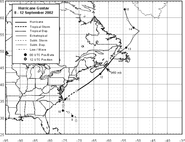
Figure 1:
Best track positions for Hurricane Gustav, 8 - 12 September 2002. Track during
the extratropical stage is based on analyses from the NOAA Marine
Prediction Center.
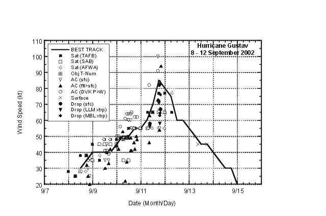
Figure 2:
Selected wind observations and best track
maximum sustained surface wind speed curve for Hurricane Gustav, 8
- 12 September 2002. Aircraft observations have been adjusted for
elevation using 90%, 80%, and 80% reduction factors for
observations from 700 mb, 850 mb, and 1500 ft, respectively.
Dropwindsonde observations include actual 10 m winds (sfc), as well
as surface estimates derived from the mean wind over the lowest 150
m of the wind sounding (LLM), and from the sounding boundary layer
mean (MBL). Estimates during the extratropical stage are based on
analyses from the NOAA Marine Prediction Center and the Canadian
Hurricane Center.
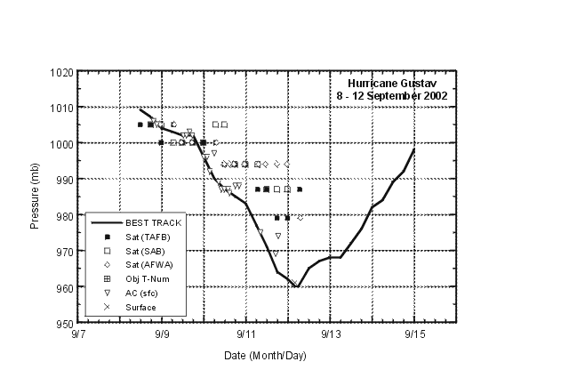
Figure 3:
Selected pressure observations and best
track minimum central pressure curve for Hurricane Gustav, 8 - 12
September 2002. Estimates during the extratropical stage are based
on analyses from the NOAA Marine Prediction Center and the Canadian
Hurricane Center.
|


