Tropical Cyclone Report
Tropical Storm Ana
20 - 24 April 2003
Jack Beven
National Hurricane Center
19 December 2003
Ana was the first Atlantic tropical storm of record
to form in April. It moved generally eastward across the central
Atlantic.
a. Synoptic History
A non-tropical low formed about 210 n mi
south-southwest of Bermuda on 18 April when an upper-level trough
interacted with a surface frontal system. Moving generally
northward, the low produced sporadic bursts of central convection
starting early on 19 April. After turning northwestward, the low
looped back toward the southeast early on 20 April. The central
convection became better organized and the low separated from the
frontal system. It is estimated the low became a subtropical storm
at 0600 UTC 20 April about 215 n mi west of Bermuda. The "best
track" chart of Ana's path is given in Figure 1, with the wind and
pressure histories shown in Figure 2 and Figure 3,
respectively. The best
track positions and intensities are listed in Table 1.
Additional development occurred during its first day,
and based on satellite microwave data showing a warm core it is
estimated that Ana became a tropical storm near 0000 UTC 21 April
with winds of 50 kt. This would be the peak intensity of the
system. Ana turned east-southeastward on 21 April and eastward the
next day while maintaining 45-50 kt winds. The system turned
east-northeastward on 23 April while gradually weakening, and it
merged with a cold front the next day about 810 n mi east of
Bermuda.
Ana continued eastward as a 30-35 kt extratropical
low through 25 April. It turned east-northeastward with some
intensification on 26 April, then it was absorbed by a frontal
system between the Azores and Portugal the next day.
Ana is the first tropical storm of record in April in
the north Atlantic basin. The only other tropical or subtropical
cyclone known in April is a subtropical storm between Puerto Rico
and Bermuda from 21-24 April 1992.
b. Meteorological Statistics
Observations in Ana (Figure 2 and Figure 3) include
satellite-based Dvorak and Hebert-Poteat technique intensity
estimates from the Tropical Analysis and Forecast Branch (TAFB),
the Satellite Analysis Branch (SAB) and the U. S. Air Force Weather
Agency (AFWA). Microwave satellite imagery from the NOAA
polar-orbiting satellites, the NASA Tropical Rainfall Measuring
Mission (TRMM), the NASA QuikSCAT, and the Defense Meteorological
Satellite Program (DMSP) satellites were also useful in tracking
Ana.
Two ships reported tropical-storm force winds during
Ana. The Atlantic Forest reported 44 kt
winds and a pressure of 998.0 mb at 0900 UTC 22 April. The
Rosa Delmas reported 41 kt winds at 0300
UTC 23 April.
Several aspects of Ana's best track are problematic.
The first is the timing of the cyclone's transition from an
extratropical to a subtropical cyclone. Satellite microwave wind
data showed that a tight inner wind core - a step in that
transition - formed early on 19 April. However, conventional
satellite imagery showed that the cyclone was still attached to the
frontal system at that time. The cyclone separated from the front
near 0600 UTC 20 April and therefore is estimated to have become
subtropical at that time.
A second issue is the time Ana transitioned to a
tropical cyclone. Data from the Advanced Microwave Sounder Unit on
the NOAA polar-orbiting satellites indicated that an upper-level
warm core was present by late on 20 April. Based on this, Ana is
estimated to have become tropical by 0000 UTC 21 April. However,
experimental cyclone phase diagrams (Hart 2003) suggest that the
transition could have occurred 6-18 h earlier.
A final issue regards the maximum intensity.
Estimates from satellite imagery using the Dvorak and Hebert-Poteat
techniques suggest maximum winds of 45 kt. However, data from the
Seawinds scatterometer on the QuikSCAT satellite showed 55 kt winds
west of the center at 2311 UTC 20 April. While the accuracy of this
measurement is uncertain due to the possibility of rain
contamination, it appears at least somewhat reliable when compared
to other nearby Seawinds data. The maximum intensity is set to 50
kt in a compromise between the scatterometer winds and the
intensity estimates from the Hebert-Poteat technique. There is a
possibility that Ana could have been stronger than 50 kt at the
time of that Seawinds overpass.
c. Casualty and Damage Statistics
Ana did not significantly affect any land areas, and
there were no casualties or damages from its winds and rains.
However, swells generated by Ana caused a boat to capsize at
Jupiter Inlet, Florida on 20 April. Two people onboard drowned.
d. Forecast and Warning Critique
Average official track errors (with the number of
cases in parentheses) for Ana were 37 (11), 46 (9), 79 (7), 123
(5), and 98 (1) n mi for the 12, 24, 36, 48, and 72 h forecasts,
respectively1.
These errors are lower than the average official track
errors for the 10-yr period 1993-2002 (45, 81, 116, 150, and 225 n
mi, respectively). These errors are also lower than those for the
Climatology-Persistence method (58, 140, 269, 429, and 621 n mi for
the 12, 24, 36, 48, and 72 h forecasts, respectively), and thus the
forecasts have skill relative to that measure.
Average official intensity errors were 9, 9, 9, 9,
and 10 kt for the 12, 24, 36, 48, and 72 h forecasts, respectively.
For comparison, the average official intensity errors over the
10-yr period 1993-2002 are 6, 10, 13, 15, and 19 kt
respectively.
No watches or warnings were issued for Ana.
References:
Hart, R.E., 2003: A cyclone phase space derived from
thermal wind and thermal asymmetry, Monthly Weather Review,
131, 585-616.
1All forecast verifications in this report include the
depression stage of the cyclone. National Hurricane Center verifications
presented in these reports prior to 2003 did not include the depression
stage.
Table 1: Best track for Tropical Storm Ana, 20-24 April 2003.
Date/Time
(UTC) | Position | Pressure
(mb) | Wind Speed
(kt) | Stage |
Lat.
(°N) | Lon.
(°W) |
| 18 / 0000 | 29.1 | 66.2 | 1008 | 30 | extratropical |
| 18 / 0600 | 29.9 | 66.0 | 1008 | 30 | " |
| 18 / 1200 | 30.8 | 65.8 | 1008 | 30 | " |
| 18 / 1800 | 31.9 | 66.3 | 1007 | 30 | " |
| 19 / 0000 | 33.0 | 66.9 | 1007 | 30 | " |
| 19 / 0600 | 33.8 | 67.6 | 1006 | 35 | " |
| 19 / 1200 | 34.5 | 68.6 | 1006 | 35 | " |
| 19 / 1800 | 34.3 | 69.1 | 1006 | 35 | " |
| 20 / 0000 | 33.6 | 69.0 | 1005 | 40 | " |
| 20 / 0600 | 32.7 | 68.9 | 1003 | 40 | subtropical
storm |
| 20 / 1200 | 32.0 | 68.2 | 1000 | 45 | " |
| 20 / 1800 | 31.7 | 67.3 | 998 | 45 | " |
| 21 / 0000 | 31.4 | 66.4 | 995 | 50 | tropical
storm |
| 21 / 0600 | 30.6 | 65.8 | 995 | 50 | " |
| 21 / 1200 | 30.0 | 64.8 | 995 | 50 | " |
| 21 / 1800 | 29.4 | 63.1 | 994 | 50 | " |
| 22 / 0000 | 29.4 | 61.5 | 994 | 50 | " |
| 22 / 0600 | 29.5 | 60.1 | 994 | 50 | " |
| 22 / 1200 | 29.6 | 58.5 | 995 | 45 | " |
| 22 / 1800 | 29.7 | 56.6 | 996 | 45 | " |
| 23 / 0000 | 30.0 | 54.7 | 998 | 40 | " |
| 23 / 0600 | 30.6 | 53.0 | 1000 | 40 | " |
| 23 / 1200 | 31.4 | 51.5 | 1000 | 40 | " |
| 23 / 1800 | 31.9 | 50.6 | 1001 | 35 | " |
| 24 / 0000 | 32.1 | 49.6 | 1003 | 35 | " |
| 24 / 0600 | 32.0 | 48.7 | 1004 | 35 | extratropical |
| 24 / 1200 | 31.8 | 47.8 | 1005 | 35 | " |
| 24 / 1800 | 31.5 | 46.6 | 1005 | 35 | " |
| 25 / 0000 | 31.5 | 45.4 | 1005 | 35 | " |
| 25 / 0600 | 31.6 | 44.2 | 1004 | 35 | " |
| 25 / 1200 | 31.7 | 43.1 | 1003 | 30 | " |
| 25 / 1800 | 31.8 | 42.1 | 1004 | 30 | " |
| 26 / 0000 | 31.9 | 40.8 | 1005 | 30 | " |
| 26 / 0600 | 32.3 | 38.4 | 1002 | 35 | " |
| 26 / 1200 | 32.9 | 35.6 | 1002 | 35 | " |
| 26 / 1800 | 33.6 | 32.8 | 1002 | 40 | " |
| 27 / 0000 | 34.4 | 29.2 | 1002 | 40 | " |
| 27 / 0600 | 35.3 | 25.8 | 999 | 40 | " |
| 27 / 1200 | 36.1 | 22.4 | 1000 | 40 | " |
| 27 / 1800 | | | | | absorbed by frontal
system |
| 21 / 1800 | 29.4 | 63.1 | 994 | 50 | minimum pressure |
| 22 / 0000 | 29.4 | 61.5 | 994 | 50 | " |
| 22 / 0600 | 29.5 | 60.1 | 994 | 50 | " |
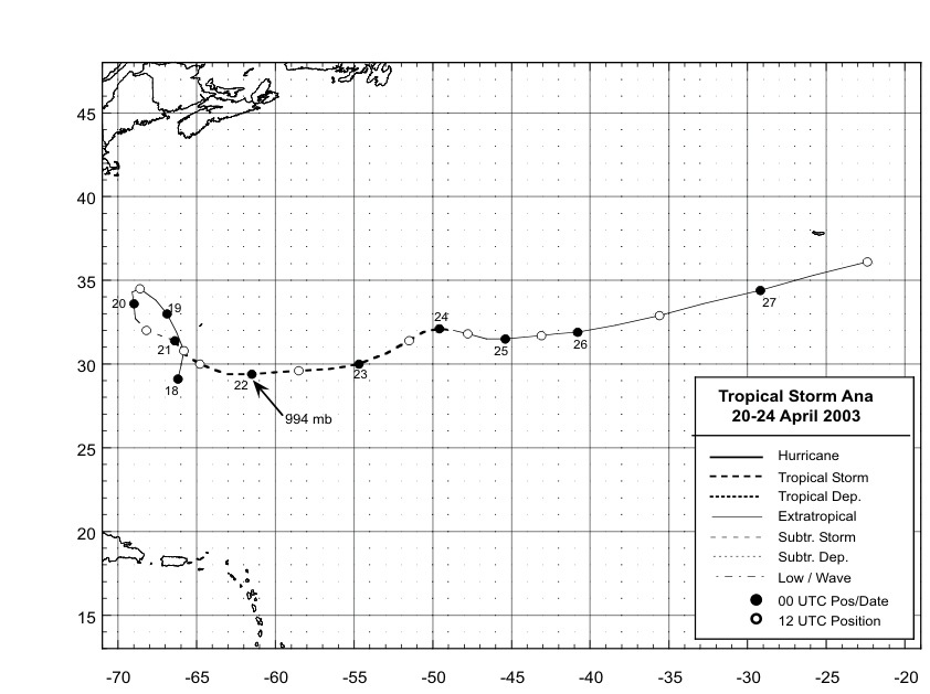
Figure 1:
Best track positions for
Tropical Storm Ana, 20-24 April 2003.
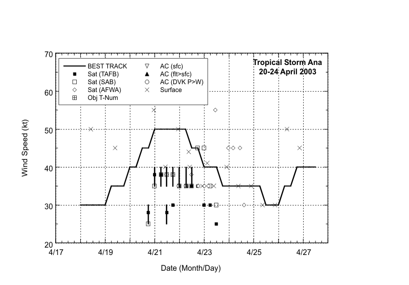
Figure 2:
Selected wind
observations and best track maximum sustained
surface wind speed curve for Tropical Storm Ana, 20-24 April
2003.Solid black bars denote wind ranges
for the Hebert-Poteat subtropical cyclone technique. X's include
surface winds from ships and the QuikSCAT scatterometer.
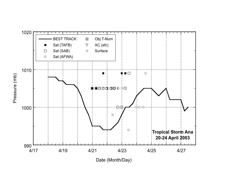
Figure 3:
Selected pressure
observations and best track minimum central
pressure curve for Tropical Storm Ana, 20-24 April 2003.
|


