|
Examine the Christina River Project
The following pages will show how using a Geographic Information System (GIS) such as ArcView can help combine various sets of data to help scientists see the possible relationships between things such as contaminant concentrations and presence/absence of aquatic species. They will guide you through some of the ways GIS can be used in watershed analysis, using the Christina River watershed as an example.
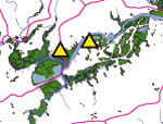
Superfund Sites and Wetlands in Northern Delaware
The National Wetland Inventory (NWI) maps for Delaware indicate a series of large riparian wetlands along the Christina River. Two of the three Superfund (National Priorities List (NPL)) hazardous waste sites located along the Christina River are near this large wetland system.
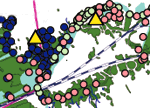
Data Sets Used in Christina River Project Analysis
Sediment chemistry data from the three Superfund sites are combined with data from a river survey done by the Delaware Department of Natural Resources and Environmental Control (DNREC). At each station, a sediment sample was collected. The mapped distributions of sediment contaminant concentrations provides an overview of the potential for toxicity in the various habitats used by river herring and shad as they migrate along the Christina.
|