|
| Storm Reports |
| Are you interested in what happened during a recent event? Check out the
report below. |
|
|
 |
Heavy Snow on March 6-7, 2008 (Pg1) |
 |
| |
| Heavy snow fell across northern and western Arkansas late on March
3rd into the 4th. Yet another heavy snow event affected the region
on the 6th...and continued into the 7th. |
| |
 |
A front pushed through Arkansas on the 5th and stalled along the Gulf Coast. Several storm systems
formed along
the front, and sent moisture northward into colder air across
Arkansas. |
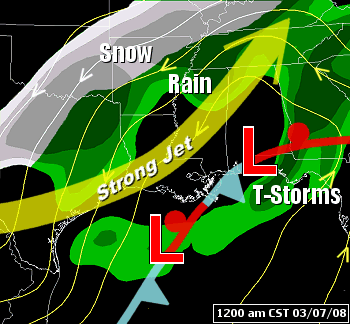
| In the picture:
The pattern at 12 am CST on 03/07/2008...with storm systems
("L") forming along a stalled front in the Gulf of Mexico, and
widespread precipitation north of the front. A strong jet (110 to 120
knots at 30,000 feet) was noted, with a lot of lifting north of the
jet (with increased ventilation overhead). |
| The moisture built into northern and western sections of
the state during the late morning and afternoon of the 6th,
with snow developing. |

|
| In the picture:
The satellite showed moisture/clouds increasing from Texas into Oklahoma
and western Arkansas as of 11 am CST on 03/06/2008. A storm system
("L") was in south Texas, with an intensifying system aloft
("X") in eastern New Mexico. |
 |
By 3 pm CST, some areas north and west of Little Rock had
already received an inch of snow. |
| In the picture:
The WSR-88D (Doppler Weather Radar) showed snow building into northern
and western Arkansas as of 209 pm CST on 03/06/2008. Temperatures in
these areas were in the lower to mid 30s. |
 |
| In the
pictures: A cross section from Harrison (Boone County) to
Monticello (Drew County) indicated that temperatures were cold enough and moisture deep enough for snow
north and west of Little
Rock (Pulaski County) at 12 am CST on 03/07/2008. Data showed
temperatures cooling at ground level and aloft, with rain
changing to snow farther south and east later in the day. |
|
|
|
Snow continued into the early morning hours of the 7th north
and west of Little Rock (Pulaski County), and was heavy at times. There was
a mixture of rain and sleet farther south and east. It was also windy, with
gusty north to northeast winds at 15 to 25 mph and gusts over 30 mph. This was
round one...with round two yet to come.
|
|
| There is more concerning heavy snow on March
6th and 7th. To check out the rest of the story, click
here. |
|
|