 |
| Storm Reports |
| Are you interested in what happened during a recent event? Check out the
report below. |
|
|
 |
Severe Weather on May 10, 2008 (Pg1) |
 |
| |
|
A very active weather pattern continued in early May, with
another round of severe weather on the 10th. |
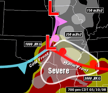
| In the
picture: Maximum instability (heat/humidity to make the atmosphere more
buoyant) and helicity (potential for rotating winds) overlapped along
a warm front in central Arkansas as of 7 pm CDT on 05/10/2008. CAPE
(Convective Available Potential Energy...or a measure of instability)
values were about as high (over 2000 J/kg) as they have been this
Spring, and 0-1 km helicity was high enough (150 to 300 m2/s2) to be
concerned about tornadoes. |
| A cold front pushed through Arkansas from the north on
the 9th, but stalled and returned as a warm front on the 10th.
Warm/moist air surged into the state from the Gulf Coast region
behind the front, with afternoon temperatures in the 70s and 80s (an
unstable/buoyant atmosphere) across central and southern sections of the
state. Surrounding the front, there were
east to southeast winds at ground level and south to southwest winds a
few thousand feet aloft (turning winds with height). Thunderstorms developed
north of the warm front during the afternoon hours of the 10th, with
mainly hail produced north of Little Rock (Pulaski County).
Golfball size hail was reported near Ponca (Newton County), Guion
(Izard County) and Morning Star (Searcy
County). Quarter size hail fell at Cave City (Sharp County).
|
| Toward evening, storms fired up closer to the front in
central sections of the state. Not only did hail continue, but rotation
was more prevalent and tornadoes were noted. |

|
| In the
picture: The satellite showed storms building in central Arkansas near a
warm front during the evening of 05/10/2008. Temperatures south of the
front were in the 70s/80s, with 60s farther north. |
|
There were two supercells (storms with rotating updrafts)
that became dominant between 6 pm and 7 pm CDT. One of the supercells downed trees
at Joy and Searcy (both in White County) before spawning a
tornado east of Augusta near Tipp (both in Woodruff County). |
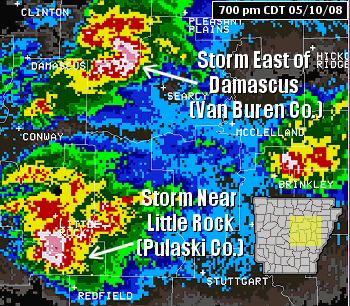
| In the
picture: The WSR-88D (Doppler Weather Radar) showed two main storms in
central Arkansas at 700 pm CDT on 05/10/2008. Both storms had high
reflectivity (white/pink colors); that is, much of the energy used to
sample the storms was returned to the radar. Ice tends to be a very good
reflector, and there was plenty of hail reported. |
| The other supercell tracked just south of Little
Rock (Pulaski County), with golfball size hail reported on the
south side of town and also at England (Lonoke County). The
storm then produced a tornado at Stuttgart (Arkansas County).
|
| Major damage occurred in Stuttgart
(Arkansas County). Nine injuries were reported, with an elderly woman
trapped in her home. |

|
| In the
picture: The WSR-88D (Doppler Weather Radar) showed strong rotation with
two supercells in central Arkansas as of 801 pm CDT on 05/10/2008. The
storms were likely producing tornadoes simultaneously. |
|
Some Notes |
|
(1) A Discovery Channel camera crew was at the National
Weather Service in Little Rock (Pulaski County) during the afternoon
and evening of the 10th, and filmed during warning operations. |
|
(2) A chase team from the University of Oklahoma was in
Arkansas with the portable Doppler On Wheels (DOW), and managed to
obtain data from the tornadic supercell that hit Stuttgart (Arkansas
County). |
| Later in the evening, an intensifying storm system in
Missouri dragged a cold front into Arkansas. Additional storms were
triggered along the front, mainly in the southern counties. One cluster
of storms downed numerous trees from Camden southwest through Buena
Vista and Stephens (all in Ouachita County). Some trees fell on houses. |
|
| There is more concerning severe weather on
May 10th. To check out the rest of the story, click
here. |
|
|