|
| Storm Reports |
| Are you interested in what happened during a recent event? Check out the
report below. |
|
|
 |
Severe Weather on January 7-8, 2008 (Pg1) |
 |
| |
| An
Historic Event |
| |
| One of the largest January tornado outbreaks in recorded history occurred on
the 7th and 8th. There were 54 tornadoes spawned. Arkansas was mostly spared, but
not entirely. There were six (6) tornadoes in the state, with one person killed
in Pope County (near Appleton).
|
| Large
January Tornado Outbreaks |
| When |
Where |
#
Tornadoes |
| January 21-22, 1999 |
AR, LA, MS, MO |
80 |
| January 7-8, 2008 |
AR, IL, MS, MO, OK, TN, WI |
54 |
| January 9-12, 1975 |
AL, AR, FL, IL, IN, LA,
MS, OK, TX |
45 |
| January 24, 1967 |
IL, IA, MO, OK, WI |
32 |
| This outbreak was preceded by record warmth (on the 6th),
which is not unusual before such an outbreak occurs. It is interesting
to note that a couple of tornadoes tracked through southeast Wisconsin
on the 7th. This is the farthest north that tornadoes have occurred in
January since the outbreak of January 24, 1967.
While outbreaks like this are somewhat unusual this time of year (and more
common in Spring), there were at least a dozen more tornadoes in Alabama
and Mississippi a couple of days later (on the 10th). |
|
After a rather cold start to the new year (high
temperatures in the 20s and 30s on the 2nd), it became rather mild
(60s and 70s on the 6th). Instead of snow and ice, the
focus shifted to thunderstorms and severe
weather. |
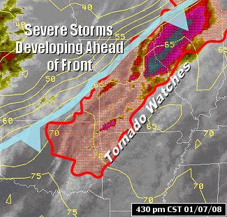
| In the picture:
The satellite showed thunderstorms developing ahead of a cold front in the mid-Mississippi Valley, with Tornado Watches in effect as of 430 pm CST on 01/07/2008.
Storms were just beginning to pop up in southwest Missouri and northeast
Oklahoma with temperatures in the upper 60s and lower 70s. |
| High
Temperatures |
| Site |
Jan
2nd |
Jan
6th |
Difference |
| Fayetteville (NW AR) |
28° |
72°(R) |
+44° |
| Harrison (NC AR) |
28° |
72°(R) |
+44° |
| Jonesboro (NE AR) |
30° |
70°(R) |
+40° |
| Fort Smith (WC AR) |
34° |
76°(R) |
+42° |
| Little Rock (C AR) |
36° |
76° |
+40° |
| North Little Rock (C
AR) |
34° |
72°(R) |
+38° |
| West Memphis (EC
AR) |
27° |
67° |
+40° |
| Texarkana (SW AR) |
38° |
77°(R) |
+39° |
| El Dorado (SC AR) |
39° |
75° |
+36° |
| Monticello (SE AR) |
35° |
70° |
+35° |
| R - Record
high temperature was tied or broken. |
| A strong cold front approached from the Plains during the
afternoon of the 7th. Thunderstorms developed along/ahead of the front
from Wisconsin into Illinois and Missouri. |
| During the evening hours, storms continued building from southwest Missouri
into eastern Oklahoma and far northwest Arkansas (Benton County). |
|
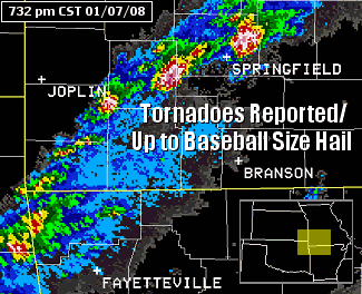
| In the picture:
The WSR-88D (Doppler Weather Radar) showed scattered severe
thunderstorms across southwest Missouri and extreme northwest Arkansas
at 732 pm CST on 01/07/2008. Some of the storms were spawning tornadoes,
with up to baseball size hail. |
 |
The storms kept forming over the same areas for several
hours as the front became nearly stationary. At least three dozen
tornadoes were produced in Missouri alone, with up to baseball size hail. Three to four inches (and locally more) of
rain fell in some areas (including Springfield, MO)...with flash flooding reported. |
| In the picture:
Watches and warnings in effect as of 1015 pm CST on 01/07/2008. |
| By the early morning hours of the 8th, a storm
system in the southern Plains arrived...and dragged the front to
the east. Thunderstorms and severe weather shifted more into Arkansas.
There were more tornadoes to come. |
|
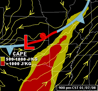
| In the picture:
The weather pattern at 900 pm CST on 01/07/2008...with a nearly
stationary front and a storm system ("L") in the Plains, and severe
thunderstorms in northwest Arkansas. Helicity (representing
the potential for rotating winds) was high (over 200 m2/s2) and CAPE
(Convective Available Potential Energy...or a measure of instability)
was ample enough (over 1000 J/kg) for severe weather. |
|
| There is more concerning the storms of
January 7th-8th. To check out the rest of the story, click
here. |
|
|