 |
| Storm Reports |
| Are you interested in what happened during a recent event? Check out the
report below. |
|
|
 |
Heavy Rain/Wind on September 1-4, 2008 (Pg1) |
 |
| |
|
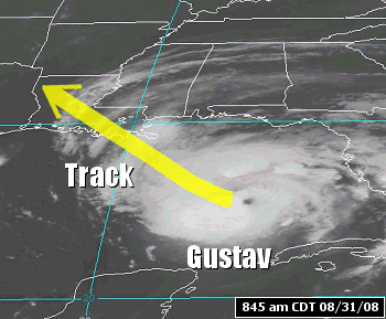
Hurricane Gustav reached the Louisiana Gulf Coast during
the late morning of September 1st. |
| In the
picture: The satellite showed Hurricane Gustav in the Gulf of Mexico at
845 am CDT on 08/31/2008. |
| The system came ashore about 65 miles southwest of New
Orleans, Louisiana as a Category 2 storm with sustained winds of 110 mph.
From there, Gustav moved northwest and slowed down. It weakened to a
Tropical Depression by the early morning hours of the 2nd. |
| The remnants of Gustav drifted into northwest Louisiana
during the afternoon of the 2nd, and into southwest Arkansas on the 3rd.
A lot of rain and wind surrounded the system. |
|
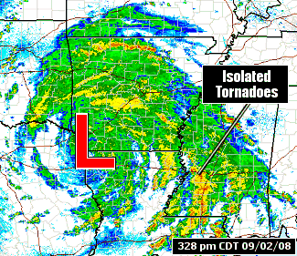
| In the
picture: The WSR-88D (Doppler Weather Radar) showed rain spiraling around
the remnants of Gustav ("L") in extreme northwest Louisiana at
328 pm
CDT on 09/02/2008. |

|
More than 8 inches of rain fell in portions of western,
central and southeast Arkansas. Seventy two hour totals through 7 am CDT on the
4th included 11.50 inches at Bismarck (Hot Spring County), 11.26 inches at Leola (Grant
County), 10.90 inches at Jacksonville (Pulaski County) and 10.65 inches at Hampton (Calhoun
County). Widespread flash flooding was reported, with roads covered by water. |
| In the
picture: Seventy two hour rainfall totals through 7 am CDT on 09/04/2008. "E" is
estimated precipitation. |
| Much of the region was primed for high water problems. A
wet August (200 to 300 percent of normal rainfall) saturated the ground, and water
tended to runoff during this event instead of going into the soil. |
| Rainfall
in August, 2008 |
| Site |
Rain (Inches) |
Departure (Inches) |
Percent
of Normal |
| Fayetteville (NW AR) |
5.87 |
+2.87 |
196% |
| Harrison (NC AR) |
6.48 |
+3.07 |
190% |
| Jonesboro (NE AR) |
4.57 |
+1.90 |
171% |
| Fort Smith (WC AR) |
7.42 |
+4.86 |
290% |
| Little Rock (C AR) |
5.80 |
+2.87 |
198% |
| North Little Rock (C
AR) |
6.18 |
+3.21 |
208% |
| West Memphis (EC
AR) |
2.31 |
-0.59 |
80% |
| Texarkana (SW AR) |
5.48 |
+3.13 |
233% |
| El Dorado (SC AR) |
8.96 |
+5.74 |
278% |
| Monticello (SE AR) |
7.96 |
+4.64 |
240% |
| Windy conditions were prolonged, and 30 to 40 mph gusts
were frequent (especially in the southwest half of the state). |
|
Wind Conditions (Direction/Speed in mph) |
| Site |
Sep 2nd (11 am CDT) |
Sep 3rd (11 am CDT) |
| Fayetteville (NW AR) |
VRB05 |
NE13G24 |
| Harrison (NC AR) |
E12G20 |
E17G26 |
| Jonesboro (NE AR) |
E12 |
NE12 |
| Fort Smith (WC AR) |
NE18 |
NE24G35 |
| Little Rock (C AR) |
E22G29 |
E20G28 |
| North Little Rock (C
AR) |
E22G30 |
E22G28 |
| West Memphis (EC
AR) |
E21G29 |
E13 |
| Texarkana (SW AR) |
NE16G23 |
S12 |
| El Dorado (SC AR) |
E13G32 |
SE12 |
| Monticello (SE AR) |
E22G35 |
SE13G28 |
| Ordinarily, winds of this magnitude might snap some tree limbs
or down a few small trees. However, a nearly saturated soil made trees
more vulnerable...and many trees and power poles were toppled. |
| There was a concern about tornadoes as well. On the 2nd,
fast moving storms in rain bands to the east of Gustav produced isolated tornadoes in eastern Louisiana and
Mississippi. These areas had some warming during the afternoon, and
instability increased. |
| Instability values also went up in portions of northern Arkansas and
southern Missouri. Toward the evening hours of the 2nd, a few storms in
these areas began to rotate...which prompted Tornado Warnings. |
|
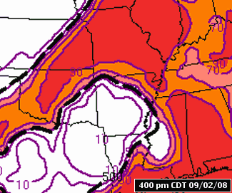
| In the
picture: Probabilities (in %) of CAPE (Convective Available Potential
Energy...or a measure of instability) of at least 500 J/kg from 4 pm CDT on
09/02/2008 to 4 pm CDT on 09/03/2008. The graphics in
the loop are courtesy of the Storm Prediction Center. |
|
| There is more information concerning heavy rain on September 1st
through the 4th. To check out the rest of the story, click
here. |
|
|