 |
| Storm Reports |
| Are you interested in what happened during a recent event? Check out the
report below. |
|
|
 |
Heavy Rain on August 9-12, 2008 |
 |
| |
|
| Excessive rain occurred from August 9th through the 12th,
mainly in the southwest half of Arkansas. A few areas picked up more than
10 inches of precipitation! Usually, totals like these in the Summer are the result of tropical
systems. Not so in this case.
Much of this rain fell where well below normal precipitation was
noted in July/early August. Given this, water tended to soak into the
ground with very little flash flooding.
|

|
It all began after a cold front pushed through the area
and exited to the south and west on the 8th. The front stalled as it became parallel to a northwest
wind flow aloft. |
| In the
picture: The weather pattern at 1 pm CDT on 08/10/2008. Showers
and thunderstorms developed along and north of a stalled front, with
areas of heavy rain in Arkansas. High pressure ("H") and
excessive heat were well to the southwest. |
|
Several systems aloft rode the flow into the region from
the Plains, and interacted with the front. A few rounds of showers and thunderstorms
resulted. |

|
| In the
picture: A cross section of the atmosphere showed warmer air to
the southwest of Arkansas overrunning cooler air in Arkansas, with deep
moisture and precipitation resulting as of 7 am CDT on 08/10/2008. A
stalled front separated these airmasses. Temperatures (in degrees C) are
depicted by solid yellow lines. |

|
One round took place late on the 9th and into the 10th, with heavy precipitation
in southern and western Arkansas. |
| In the
picture: The satellite showed two large clusters of showers and
thunderstorms building into Arkansas from the northwest at 431
am CDT on 08/10/2008. |
| Clouds and precipitation kept temperatures well below
normal across the region on the 10th. Maximum readings were 15 to 25
degrees below those reached on the 5th (before the front passed through)
. |
| High
Temperatures (August, 2008) |
| Site |
Aug
5th |
Aug
10th |
Difference |
| Fayetteville (NW AR) |
97° |
78° |
-19° |
| Harrison (NC AR) |
95° |
70° |
-25° |
| Jonesboro (NE AR) |
98° |
79° |
-19° |
| Fort Smith (WC AR) |
103° |
76° |
-27° |
| Little Rock (C AR) |
97° |
73° |
-24° |
| North Little Rock (C
AR) |
98° |
74° |
-24° |
| West Memphis (EC
AR) |
93° |
73° |
-20° |
| Texarkana (SW AR) |
97° |
78° |
-19° |
| El Dorado (SC AR) |
99° |
81° |
-18° |
| Monticello (SE AR) |
96° |
77° |
-19° |
| The south and west were hit again on the 11th, with high
temperatures only in the 70s. There was little to precipitation in the northeast half of the
state, and more sunshine allowed readings to warm into the 80s. |
| A dry northeast wind behind the stalled front brought
lower dewpoints into the northern and eastern counties. This prevented
rain from building into these areas. |

|
| In the
picture: Dewpoints were only in the lower to mid 60s (dry air) across
northeast Arkansas at 3 pm CDT on 08/11/2008. |
|
And where it rained, it added up. Much of the south and
west received 3 to 6 inches of rain, with locally over 8 inches. |
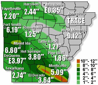
| In the
picture: Seventy two hour (three day) rainfall through 7 am CDT on
08/12/2008.
"E" is estimated precipitation. |
| Some seventy two hour rainfall totals through 7 am CDT on the
12th included 10.88 inches at Portland (Ashley County), 10.46 inches at
Eudora (Chicot County), 10.30 inches at Hampton (Calhoun County), and
8.48 inches at Warren (Bradley County). All of these locations are in
south central or southeast Arkansas. |
|
|


