|
| Storm Reports |
| Are you interested in what happened during a recent event? Check out the
report below. |
|
|
 |
Heavy Rain/Severe Weather on March 17-19, 2008 (Pg1) |
 |
| |
| Historic
High Water |
| |
| Much of the region was impacted by
this heavy rain to high water event. Arguably, the last event of this
magnitude occurred in December, 1982. |
 |
Very heavy rain began developing late on the 17th in
northern and western Arkansas, and continued on the 18th/early on the 19th as a powerful storm system
approached from Texas. |
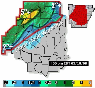
| In the picture:
The pattern at 12 pm CDT on 03/18/2008, with precipitable water values
increasing markedly ahead of a storm system ("L") in Texas.
Precipitable water, or water vapor contained in a vertical column of at
atmosphere, is normally between .50" and .75" in mid-March.
These values were more than doubled during this event. |
| Precipitable
Water Values at North Little Rock (Pulaski County) |
| Date |
Time |
Value
(Inches) |
| March 16, 2008 |
7 pm CDT |
0.49 |
| March 17, 2008 |
7 am CDT |
0.73 |
| March 17, 2008 |
7 pm CDT |
1.28 |
| March 18, 2008 |
7 am CDT |
1.38 |
| March 18, 2008 |
1 pm CDT |
1.58 |
|
The system dredged copious moisture from the Gulf of
Mexico, and sent it toward Arkansas with a deep southerly wind
flow. Well above normal precipitable water was noted, which enhanced rainfall efficiency across the region.
By 4 pm CDT on the 18th, two to five inches of rain was common in the
northern and western counties...with locally over five inches of rain
(especially in Newton and Searcy Counties).
|
|
|
|
| In the
picture: Widespread heavy rain was occurring
in northern and western Arkansas of 4 pm CDT on 03/18/2008, with
numerous Flash Flood Warnings in effect. The WSR-88D (Doppler Weather Radar) estimated
more than five inches in some spots. |
|
|
|
Very serious flash flooding was occurring across the north and west,
with several highways closed and roads washed out. Water was flowing into homes
in some areas, including Everton (Boone County). The water was already
affecting area tributaries, with rapidly rising water on portions of the
Buffalo, White and Spring Rivers.
At Calico Rock (Izard County), evacuations were under way along the
White River with water expected to far exceed the flood stage.
Evacuations were also taking place at Hardy
(Sharp County), with the Spring River already above the flood stage.
By 530 pm CDT, many roads were closed in Stone County. Local law
enforcement officials were urging people not to drive in the county.
|
|
Spring River at Hardy (Sharp County)/Flood Stage 10
Feet |
| Date |
Time |
Stage (ft) |
| March 18, 2008 |
630 am CDT |
5.08 |
| March 18, 2008 |
1030 am CDT |
7.32 |
| March 18, 2008 |
230 pm CDT |
12.83 |
| March 18, 2008 |
630 pm CDT |
18.42 |
| March 18, 2008 |
1030 pm CDT |
20.47 |
| March 19, 2008 |
230 am CDT |
21.07 |
| March 19, 2008 |
630 am CDT |
22.13 |
| March 19, 2008 |
1030 am CDT |
20.81 |
| March 19, 2008 |
230 pm CDT |
18.86 |
| March 19, 2008 |
630 pm CDT |
17.05 |
| Note: The river crested
at 22.29 feet at 730 am CDT on the 19th. |
| By 7 am CDT on the 19th, four to six inches of rain was
measured north and west of Little Rock (Pulaski County)...with locally
over eight inches. |
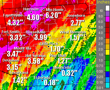 |
| In the picture:
Twenty four hour rainfall through 7 am CDT on 03/19/2008. |
| On the morning of the 19th, people stranded by high
water were being rescued by helicopter between Flippin (Marion County) and
Fairview (Marion County). Near Timbo (Stone County), a man was missing after his vehicle was swept off
the road by flood waters. Another man was missing near West Fork (Washington County) after he tried to
drive through a low water crossing. The bodies of both men were eventually found (on the 22nd and 29th
respectively). |
| Keys
to Flooding |
|
(1) Heavy rain/heavy snow fell across much of northern
Arkansas on March 2nd through the 4th, followed by another heavy
snow event on the 6th/7th. The ground was nearly saturated, and
could not hold much more water. |
|
(2) Vegetation was mostly dormant, with little use of
available ground water. This allowed runoff to increase more quickly
once heavy rain began. |
|
(3) Well above normal moisture levels created more water
to wring out of the atmosphere. This elevated the likelihood of
heavy to excessive rain. |
 |
During this time frame, major flooding was occurring along
the Buffalo River at St. Joe (Searcy County) and the Spring River at Hardy
(Spring River). River levels in both locations were in the Top 5 highest
crests on record. |
| In the picture:
The Buffalo River was running high along the Highway 14 bridge in southern
Marion County on 03/19/2008. The picture is courtesy of David Martin.
Click to enlarge. |
|
Crests Along the Buffalo, Spring, Black and White Rivers |
|
Location |
River |
Crest (ft) |
Flood Stage (ft) |
Date/Time |
Rank |
| St. Joe (Izard Co) |
Buffalo |
49.41 |
27 |
03/19 (8 am CDT) |
3 |
| Hardy (Sharp Co) |
Spring |
22.29 |
10 |
03/19 (730 am CDT) |
1 |
| Calico Rock (Izard Co) |
White |
39.64 |
19 |
03/20 (1215 am CDT) |
NA |
| Batesville
(Independence Co) |
White |
27.00 |
15 |
03/20 (9 am CDT) |
8T |
| Corning (Clay Co) |
Black |
15.92 |
15 |
03/22 (6 am CDT) |
2 |
| Pocahontas (Randolph Co) |
Black |
26.52 |
17 |
03/22 (6 pm CDT) |
2 |
| Black Rock (Lawrence Co) |
Black |
29.71 |
14 |
03/20 (3 am CDT) |
4 |
| Newport (Jackson Co) |
White |
33.98 |
26 |
03/21 (12 pm CDT) |
6 |
| Augusta (Woodruff Co) |
White |
38.41 |
26 |
03/22 (9 pm CDT) |
4 |
| Georgetown (White Co) |
White |
30.18 |
21 |
03/24 (6 am CDT) |
7 |
| Des Arc (Prairie Co) |
White |
33.74 |
24 |
03/25 (11 pm CDT) |
4 |
| Clarendon (Monroe Co) |
White |
33.04 |
26 |
03/29 (3 pm CDT) |
5 |
| Note: "NA"
is not in the Top 10 crests. "T" is tied. |
|
Major flooding impacted locations along the upper White River as
well...including Calico Rock (Izard County), Batesville (Independence
County) and Newport (Jackson County). River levels at the latter two
locations were in the Top 10 highest crests on record (on the
20th/21st).
On the Black River, runoff from excessive rain in southeast Missouri
made its way into northeast Arkansas. Near record crests occurred at Corning (Clay County) and Pocahontas (Randolph County) on
the 22nd.
|
| A
Serious Situation |
| On the 22nd, the Black River was at its
highest level in at least 60 years. Water from the Black River and the upper reaches of the
White River were flowing into the lower White River during the last week
in March. |
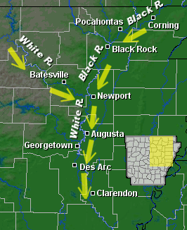 |
| In the picture:
High water from the Black and upper White Rivers ended up in the
lower reaches of the White River, with days of flooding. |
| It was taking time
for all of this water to flow downstream, given that the lower White
River was already running high. Given this, widespread flooding persisted
as March ended from Pocahontas (Randolph
County) southward through Black Rock (Lawrence County), Newport (Jackson County), Augusta (Woodruff
County), Georgetown (White County), Des Arc (Prairie County) and
Clarendon (Monroe County).
At Georgetown (White County), the only road into town (Highway 36)
was closed as of 6 am CDT on the 22nd...and remained impassible as the month closed.
During the evening of the 22nd, a levee was breached near Pocahontas
(Randolph County)...with water spilling into small communities south of
town.
|
|
| There is more concerning heavy rain and
severe weather on
March 17th through the 19th. To check out the rest of the story, click
here. |
|
|