|
 |
| About This Page |
| As the old saying goes..."If you don't like the weather today, just
wait until tomorrow." And as the weather changes, there is sometimes a picture
waiting to be taken. |
|
|
| Maybe it's a severe storm. Or it could be a winter scene.
Then again, it might be something odd. The possibilities are endless. |
|
|
 |
Weather Shots |
 |
|
| The following images are highlights of the
year 2008. Click on the images to enlarge. |
| |
 |
 |
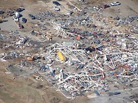
| A killer
tornado (rated EF4) cut a 123 mile swath through seven counties
on 02/05/2008. Here, a boat factory was destroyed by the tornado
at Clinton (Van Buren County). |
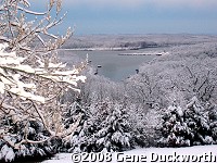
Heavy
snow (more than a foot in some cases) blanketed portions of
northern and western Arkansas on 03/07/2008...including the
Oakland (Marion County) area. The photo is courtesy of Gene
Duckworth. |
 |
 |
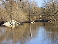
| Major flooding
occurred along the upper reaches of the White River in March. A motel was
under water at Calico Rock (Izard County) on 03/20/2008. |
Tornadoes
returned in April. There was not much left of this pickup truck at
a dealership in Cabot (Lonoke County) after a tornado (rated EF2) passed
through on 04/03/2008. |
 |
 |
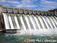
| It
rained so much that all flood gates were opened at Norfork Dam (Baxter County) on 04/10/2008.
On a normal day, 6800 cubic feet per second is released. On this
day, it was up to 82000 cubic feet per second! The picture is courtesy of Mel Coleman. |
There
were two tornado oubreaks in May, with a large tornado (rated
EF3) leveling this business in Stuttgart (Arkansas County) on
05/10/2008. |
 |
 |
| A fire apparently started by lightning destroyed a mobile home 2 miles northwest of Glen Rose (Hot Spring County) during the evening of 06/09/2008. |
Up to quarter size hail fell at Gravel Ridge (Pulaski County) during the afternoon of 07/31/2008. The picture is courtesy of Myra Bauer. |
| To look at highlights from the year
2007, click here. |
|


