|

Alaska Harbor Seal Task Leader and coauthor
Dave Withrow holding a juvenile harbor seal.
|
The Pacific harbor seal, Phoca
vitulina, is a common pinniped species found off
the west coast of North America, throughout most of
coastal Alaska, and from Baja California to Cape
Newenham in the Bering Sea. Fifty years ago, the
Pacific harbor seal was so abundant in Alaska (and
perceived a conflict with commercial fisheries) that
the state issued a bounty for the animal that
continued until the early 1970s. Since that time,
the numbers of harbor seals in areas of Alaska have
declined dramatically—up to 90% at some haul-out
sites.
Accurate range-wide abundance
figures for the 1970s are not available to assess
the impact this decline has had on the
population as a whole, its availability to native
subsistence hunters, or the degree of the species’
interactions with commercial fisheries.
State and Federal biologists have been collecting
harbor seal count data sporadically since the 1940s.
However, until the past decade most of these counts
have been incidental to other ongoing studies
such as pelagic fur seal research and counts for
Steller sea lions, sea otters, and other marine
mammals conducted in the 1970s under NOAA’s Outer
Continental Shelf Environmental Assessment Program
(OCSEAP). The Alaska Department of Fish and Game
(ADF&G) also began to record numbers of
harbor seals in the 1970s in selected areas in
Alaska in order to establish sites for long-term
trend analysis. Data from the ADF&G studies have
shown that at the trend site Tugidak
Island, south of Kodiak Island, counts of harbor
seals declined 85% between 1976 and 1988.
With the reauthorization of the Marine Mammal
Protection Act in 1988, an increased effort began on
Federal and State levels to establish reliable
population estimates for Alaska pinnipeds. In 1991,
the Alaska Harbor Seal Task of the National Marine
Mammal Laboratory (NMML) initiated a survey
project to generate a minimum population estimate
for Alaska harbor seals. Over the past 10
years, the Harbor Seal Task has conducted
comprehensive surveys specifically designed to
assess harbor seal abundance in Alaska. The surveys
represent the first state-wide attempt targeting
harbor seals throughout their Alaskan range. The
Task has developed aerial census procedures and
continues to update and refine its survey methods
using state-of-the-art imaging, mapping, and
computer technologies. NMML biologists have
also developed new capture techniques for tagging
studies in order to generate correction factors to
improve the accuracy of Alaska harbor seal abundance
estimates.
The size of the harbor seal’s geographic range in
Alaska in conjunction with budgetary constraints
prohibited its coverage in a single survey season.
The NMML divided the range into four sections
covering the Gulf of Alaska, the Aleutian Islands
chain, Bristol Bay and the north side of the Alaska
Peninsula, and Southeast Alaska. At the onset
of the 1998-99 seasons, Southeast Alaska was further
divided into northern and southern sections. One
section per survey season is covered, and the entire
Alaska range is now completed every 5 years. The
Task recently completed its third survey season
within the 5-year survey cycle: the northern half of
Southeast Alaska—1997; the southern half of
Southeast Alaska—1998; the Aleutian
Islands—1999; the north side of the Alaska
Peninsula and Bristol Bay—2000; and the Gulf of
Alaska, including Prince William Sound—2001.
Within the Pacific harbor seal’s Alaska range,
the National Marine Fisheries Service recognizes
three distinct management units or stocks: 1)
the Southeast Alaska stock occurring from Cape
Suckling (144EW) south to the Alaska/British
Columbia border, 2) the Gulf of Alaska stock from
Cape Suckling to Unimak Pass and the Aleutian Island
chain and, 3) the Bering Sea stock including all
waters north of Unimak Pass.
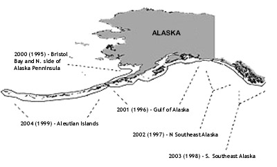
Survey zones and survey years for the
Alaska harbor seal population census.
Aerial Surveys
Aerial surveys have long been used in wildlife
biology to establish minimum population estimates
for certain animal species. Airplanes cover large
areas quickly and efficiently. Within the
field of marine mammal research, aerial surveys are
especially appropriate for assessing pinniped
populations because the animals frequently and
predictably haul out on dry land or ice. In the case
of the Alaska harbor seal, aerial surveys are the
standard methodology by which the population is
assessed.
NMML aerial surveys are done in cooperation with
ADF&G surveys and are scheduled to coincide with
the Alaska harbor seal’s annual molt in August,
the longest time the animals spend hauled out on
land or ice. During the second or third week
in August, a tidal cycle is selected when the tides
are low during daylight hours and the cycle of near
minus tides lasts from 8-10 days. Surveys are
flown within 2 hours on either side of low tide when
we expect the greatest number of seals to be hauled
out.
Most surveys are flown in small, high-wing, single
engine, amphibious aircraft. Amphibious planes are
an important safety factor since many of the surveys
are conducted in remote areas where landing
facilities are few, fuel is scarce, and land masses
are separated by large expanses of open water.
Certain survey areas require the use of more
specialized aircraft. For the area west of Adak
Island, we charter only twin-engine, amphibious
aircraft with turbine engines because they are
extremely reliable and use jet fuel, the only
aviation fuel available in this region.
Surveys are generally flown at altitudes between
500and 800 ft (150-200 meters) with a standard
survey crew of one pilot and one observer. Observers
use their naked eyes to spot haulouts and use
binoculars to make visual population estimates and
to note the type of substrate and potential sources
of disturbance to the animals, including the
aircraft itself. Examples might be natural,
such as a bear on the beach, or human caused, such
as fishing boats nearby. Disturbance is
a major factor that can, if severe enough, nullify a
count. Each haulout is photographed using high speed
color slide film and a 70-210 mm zoom lens. An
entire survey section may require seven or more
aircraft surveying simultaneously to ensure total
coverage.
A typical NMML aerial survey generates 4,000-5,000,
35-mm, color slides. The slides are processed at the
NMML facilities in Seattle and projected onto a
white acrylic board where each image is enlarged to
facilitate identifying individual animals for
counting. Each slide contains images of between 1
and 500 seals. Technicians use erasable marking pens
to cross out each image when counted to prevent
double counting and to track their way across each
slide. Slides are counted at least twice and often
by more than one technician. We are also
experimenting with computers to assist and automate
the counting process. Computer software allows
digital enhancement of poor images and stores and
retrieves each counter’s marks, as well as
archives the entire slide inventory.
During the early years of the Alaska harbor seal
survey, NMML observers kept track of their survey
positions by referencing the aircrafts’ loran
navigation equipment. Due to the large number of
sites and relatively imprecise location data, seal
numbers were usually recorded along a strip of
coastline; for example, “328 seals between SW cape
and NE point.” Beginning in 1994, NMML
observers began using hand-held global positioning
systems (GPS). The GPS records individual haul-out
sites as way points in the unit’s memory that can
be downloaded into a computer database. This has
greatly increased the precision of haul-out data by
using a latitude/longitude format, eliminated
transcription errors, and allowed the data to be
imported directly into newer navigation and
presentation software programs. Data stored in
the new format can also be incorporated in GIS
(global information system) programs and used to
analyze certain aspects of harbor seal life history,
such as population trends, migration, and residence
times.
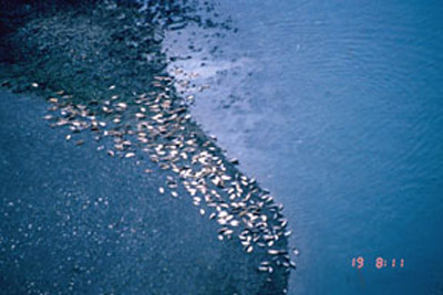
The NMML's Alaska harbor seal assessment surveys
generate up to 5,000
images of harbor seal haul-out sites documented by
aerial observers.
Correction Factor
Aerial surveys only account for animals present
during the actual fly over. However, a substantial
number of a site’s population are not present
during the aerial survey passes. A goal of the
Alaska Harbor Seal Task is to determine a correction
factor to account for the proportion of animals not
present when aerial surveys take place. Counts
from aerial assessment surveys are then multiplied
by the correction factor to provide a better
estimate of the true number of harbor seals in an
area. Depending on local geography, a haul-out
site may be composed of rocky ledges, sand bars,
gravel beaches, or floating ice. These factors
are important because haul-out behavior is specific
to haul-out substrate. For example, seals that
use sand bars don’t haul out during higher tides
(since their beach is underwater). Seals that haul
out on ice are not affected by tide, but prefer to
haul out at midday. Covariates or variables,
such as tide, time of day, weather (wind speed and
direction), all affect seal haul-out behavior, and
these effects are different for each type of
substrate used.
Development of a correction factor for population
assessment of a particular survey area necessitates
the capture, tagging, and release of seals within
that area. The basic strategy of the Harbor Seal
Task is to capture and tag about 35 seals annually.
A select number of seals utilizing a given haul-out
substrate are tagged with small radio-frequency
transmitters which broadcast signals detectable when
a seal is on land or ice, but undetectable when
submerged. Signals generated from the electronic
tags are received by the aerial survey aircraft
outfitted with a VHF receiver and special external
antennas mounted to the wing struts of the aircraft.
Signals are also recorded by remote data collection
computers stationed on shore nearby. The
remote data collection computers record each
animal’s presence or absence at 15-minute
intervals for approximately 2 months and are
retrieved at the end of the field season. Data
provided from the tagged seals along with data
gathered during the aerial censuses provide the
proportion of tagged seals hauled out during each
aerial survey, along with the total number of all
seals hauled out. This method evaluates the
combined effect of all the above mentioned
covariates. The mean of all the daily proportions is
calculated and the reciprocal of this value is the
correction factor. This corrected or adjusted value
more accurately reflects the number of seals in an
area.
Capture and Tagging
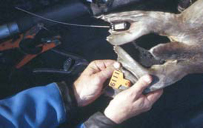
Transmitters are attached to approximately 35 Alaska
harbor seals
annually. Data generated from the tagged seals
are used to develop
a correction factor for more accurate population
estimates.
The Alaska Harbor
Seals Task’s capture methodologies have been
adapted from earlier work by the ADF&G and the
Oregon and Washington departments of Fish and
Wildlife. Capture nets are similar to salmon
gill nets; each panel measures 30 m long and 3-7 m
deep, with 30-cm, stretched-mesh openings. A
buoyant float line attaches along one long edge of
the net, a weighted lead line along the other.
Depending on site conditions, NMML biologists
lace any number of these panels together to create a
net of any length; 30- to 100-m lengths have proved
the most useful.
Capture methodology is a function of haul-out
substrate. Rocky haulouts are generally found
on shorelines composed of moderate and large
boulders and exposed bedrock. Such low-lying
areas are frequently sheltered by sloping cliffs or
large rock formations at lands edge. When
possible we use these formations as screens to hide
our slow approach by boat until the last possible
moment when we accelerate and set the net. Sand
and pebble haulouts are broad, flat areas which lack
sheltering land masses. When these are islands
or spits we approach at high speed from an area
opposite the seals, keeping the land between us and
the seals for as long as possible. This gives
us a flying start to get the net in the water before
all seals leave the beach.
Capture operations are planned to coincide with the
lowest point of the tide cycle. Using a Boston
Whaler, we encircle a haulout with a capture net,
much like a purse seine capturing tuna. Rather
than use two boats to set the net, we use a diver to
jump into the water with one end of the net and swim
it ashore while the capture boat rapidly lays net in
front of the haulout. Most seals head in the
direction of the diver, swim into the net, and are
entangled.
We generally average three to four seals per set,
although empty sets are not unusual especially
during ice captures. Entangled animals are
recovered into a capture boat, the net cut
away, and the seals transferred into restraining
hoop nets. Each animal is sexed,
weighed, and measured for length and girth; age,
stage of molt , and general health are noted; tissue
samples are taken for DNA analysis, whiskers for
stable isotope work, blood and in some cases,
blubber samples are collected for condition studies.
Processing and release takes place as close to the
point of capture as possible. Animals are usually
returned to the water within 2 hours of capture.
All animals are physically restrained. No
drugs are used. Aerial surveys are flown and remote
data recording stations set out immediately
following capture operations.
During the 1994 season the NMML focused on harbor
seals among rocky haulouts in a remote area
southwest of Ketchikan. Sixteen female and 20 male
seals were captured, tagged, and released. The
following two survey seasons (1995-96) were devoted
to sandy haulouts outside of the town of Cordova in
Prince William Sound. We took 25 and 34
animals respectively during this time; a total of 34
females and 25 males. Beginning in 1997 our
attentions focused on harbor seals on glacial ice.
|

The NOAA vessel John N. Cobb served as base
of operations during the 1997-99 seasons in
Southeast Alaska.
|
Ice-Associated
Capture
While it had long been recognized that a
substantial number of seals inhabit glacial fjords,
the difficulties associated with operations in these
remote and often hostile locations prevented any
reliable population assessments. NMML aerial
surveys over Southeast Alaska and the Gulf of Alaska
supplied information concerning the number of seals
visible on the ice but had no successful capture
methodology for ice-associated seals to generate a
correction factor.
In spring 1997 the
Task, in collaboration with Dennis McAllister of the
ADF&G, began work in the Tracy and Endicott Arms
glacial fjords in Southeast Alaska, supported by the
NOAA vessel John N. Cobb. The Tracy and Endicott
Arms are typical glacial fjords: deep,
steep-walled canyons created by advancing and
retreating glaciers. Each is about 15 km
long and 10-300 m deep. Ice conditions
vary throughout the year. During midwinter a sheet
of ice often extends from the face of the glacier to
near the mouth of the fjord; by June a boat can
usually navigate the length of the fjord, dodging
occasional icebergs.
Unlike previous tagging projects which allowed us to
modify capture techniques to fit our specific
environmental conditions, information concerning
seal capture in glacial fjords was virtually
nonexistent. From the start we adopted a trial and
error methodology, observing the animals’
reactions to such variables as types of water craft,
engine noise levels, speed of approach, and smell.
We used painted wood decoys to setup artificial
haulouts near our capture nets; experimented with
net deployment at low speed in ice-choked water;
placed divers in the water next to our nets to
bring curious seals closer. We experimented
with a net-firing gun used to capture caribou from
helicopters. At various points we disguised
ourselves with white Tyvek suits (over our
dry-suits) and covered our boat with a white
tarp as camouflage.
With only rudimentary knowledge for approaching
ice-hauled seals, we moved our operations to the
Kenai fjords National Park and continued to refine
our capture techniques. Here we adopted a stealth
approach using a small Zodiac powered by a quiet
electric motor. The two-person crew spent many hours
experimenting with net design and deployment The
remote nature of Alaska’s glacial fjords posed
logistical problems to our capture operations.
Pervasive cold and massive ice flows as the glaciers
calved added stadium-sized pieces of ice to the
already crowded surface ice. This rearranged our
nets from a straight line to a jumbled mess in a
matter of minutes, necessitating frequent retrievals
and resets. Frustrated by bad weather, lack of
experience, and poorly designed equipment we were
still successful in capturing four seals during the
1997 field season.
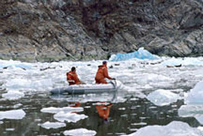
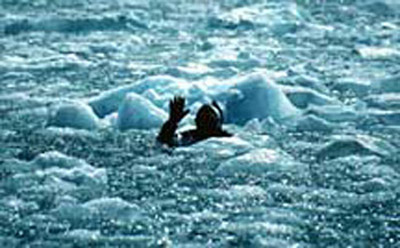
A small Zodiac and quiet motor allowed the closest
approach to seals hauled out on glacial ice. The majority
of seals were captured when approximately 50% of the water's
surface was covered by floating ice. This provided a
degree of cover for both biologists and seals
Leading up to the
1998 field season, the Task worked to modify its
capture equipment as dictated by the lessons of the
previous year. We constructed new nets incorporating
larger mesh openings (30cm). This allowed the
animals room to push their head and neck through the
mesh before actually contacting the net with their
shoulders and increased the likelihood of their
tangling. We also increased the amount of net
from the previous year and had several hundred feet
at our disposal. Each of our boats, two Boston
Whalers and a small Zodiac, were equipped with gear
necessary to deploy and recover the net. In
this way we could work together or separately as
conditions dictated. For instance, one boat
could be recovering tangled net while another made a
new set. Or all three boats could combine
their resources to surround a small group of
animals.
The Alaska Harbor Seal Task’s 1998 season in the
Kenai fjords National Park proved highly successful.
Combining the stealth approach techniques
worked out the previous year with our newly designed
equipment we captured 19 seals around the Aialik and
Pederson Glaciers. We noted while working
around theAialik Glacier that the majority of
captures happened when the surface ice cover
averaged about 50%. This seemed to offer the
greatest degree of compromise between cover for both
seals and biologists and may have increased the
animals willingness to allow our approach. Because
Pederson Glacier is offset from the main fjord and
is accessible only through a tidal channel, we
captured several animals by stretching our nets
across the narrower portions of the channel where
all seals had to pass in order to enter or exit the
glacial area.
The success of the 1998 season allowed us for the
first time to tag a large enough number of
ice-associated seals, providing us with an estimated
corection with adequate precision (cv<0.2).
Data derived from aerial reconnaissance
flights gave the average number of tagged seals
hauled out each day as 52%, providing a
correction factor of 1.92. Using data
generated from the 1998 field season efforts on
ice-associated seals, researchers can now
begin to examine in detail the dynamics of a largely
ignored, but substantial, population of Alaska
harbor seals.
Members of the Alaska Seal Task tried various
methods to improve their capture techniques for seals hauled out on glacial
ice, including assessing the seals' reaction to divers in the water.
During the 1999
field season, the NMML collaborated with Peter
Olesiuk of the Canadian Department of Fisheries and
Oceans (DFO) in British Columbia to examine the
diving behavior of harbor seals occupying glacial
fjords. Nine seals were captured in April 1999
in the Tracy Arm glacial fjord using the
methodology described above. These seals were
equipped with time-depth recording devices (TDR)
that monitored and stored the animals’ swimming
and diving profiles over a period of several months.
The instruments were glued to the hair on the
seal’s back at capture. The hairs was shed during
the annual molt and the TDR units shed along with
the hair. The free-floating units contained
VHF transmitting devices to allow for location and
retrieval. Seven of the nine TDRs were
recovered by the end of September 1999. Analysis of
the TDR data continues during winter 1999-2000 by
NMML and DFO biologists. Correction factors
will be developed along with diving and potentially
feeding profiles for each seal.
This project represents the first successful attempt
to examine the diving and feeding behavior of
fjord-dwelling harbor seals. Additionally, tissue
samples taken from these animals will be used in a
genetic analysis examining the population stock
structure of seals utilizing this unique habitat.
The NMML’s pioneering work in ice-captures has
opened new opportunities for research in previously
unstudied habitats.
We gratefully acknowledge the assistance of the NOAA
vessel John N. Cobb, the rangers of the Kenai Fjords
National Park, and the ADF&G for their
invaluable contributions during these projects.
|
