El Niño and Probability
Prashant Sardeshmukh, Gilbert Compo, and Cécile
Penland
NOAA/ESRL Physical Sciences Division
Science Writer: Susan Bacon
University of Colorado
|
|
Research and Results
To look at how ENSO affects weather outside of the tropics, Sardeshmukh, Compo, and Penland first studied the
historical record of ten El Niño years and ten La Niña years. They then used a climate model to
create a larger sample size of 180 El Niño years, 180 La Niña years, and 180 normal
years, and compared how weather responses - such as temperature and precipitation - differed around the globe
during the ENSO years. By comparing the historical record with the model results, the researchers could
confirm that the model was on target.
|
|
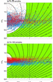
Figure 2.
Contours indicate the expected value of Dks (the amplitude of the maximum difference in
probability, change N(0,20) to N(0,1) and N(,2) to N(μ,σ) between sampled
normal distributions N(0,20) and N(,2), based on 50 000 Monte Carlo trials of (a) 25
and (b) 180 samples. Green shading indicates values significant at the 5% level,
that is, the sample N(,2) distribution can be distinguished from the sample N(0,20)
distribution. Scattered points represent the magnitudes of the mean and standard
deviation of JFM-mean 500-mb heights in the El Niño (red) and La Niña (blue) GCM
ensembles relative to those in the neutral ensemble, (a) using only the first 25
members of the 180 available members in the GCM ensembles, and (b) using all 180
members.
|
| An analysis of the model results led the research team to conclude that a lot of data is needed to tell how
ENSO affects weather. This finding is shown in Figure 2, in which each dot represents the modeled effects of
ENSO on average weather patterns at one location around the world. Red dots represent El Niño years and blue
dots represent La Niña years. Dots in the white area show locations at which researchers can't tell
whether ENSO had an effect on weather. In the top graph, using only the first 25 instead of 180 model runs,
it is impossible to tell if ENSO affected weather in most locations. However, in the bottom graph, where 180
model runs were used, a lot more dots fall outside of the white area, which shows that effects of ENSO on
weather around the world are easier to pinpoint with larger samples.
|
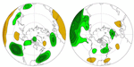
| Figure 3.
The change in the probability of extreme values of JFM-mean precipitation estimated
from the AGCM for El Niño (left) and La Niña (right) ensembles. Green (orange)
shading indicates an increase (decrease) of the probability of extreme values. The
shading contours are 5% and 25%.
|
|
| The large number of model runs provided the research team with an opportunity to explore how ENSO related
shifts in the mean state and changes in variability can alter the risk of extreme events. This type of
analysis was motivated by an interest in determining the usefulness of seasonal forecasts to identify
predictable climate extremes. In only a few regions in the United States are the ENSO related altered risk of
extreme seasonal mean winter precipitation significantly different relative to the risk of extremes under
"normal" conditions (Figure 3). Under El Niño conditions there is a significant increase in the risk
for wet and flooding conditions in California (left panel). Under La Niña conditions there is a
significant increase in the risk for dry and wildfire conditions in Florida (right panel). Not only is there
an ENSO related climate signal in these regions but the altered risk for climate extremes is a potentially
predictable aspect of seasonal climate.
|
|
Figure 4.
The difference between the standard deviations of the 500-mb height El Niño and
neutral GCM ensembles (top panel) and La Niña and neutral GCM ensembles (bottom
panel).The 500-mb height plots are drawn at 2-m intervals starting at 1-m.
Positive values, or an increase in variability, are indicated by red whereas
negative values, or a decrease in variability, are indicated by blue shading.
|
In addition to highlighting the need for large samples, the researchers found that El Niño and
La Niña events do not have equal and opposite effects on weather patterns. El Niño seems to cause
a stronger, but more variable, response than La Niña in many areas around the world. The greater
variability in 500-mbar height during El Niño years is illustrated in Figure 4, where red areas
have greater variability in weather than average, and blue areas have less variability than
average. In El Niño years, many areas have more variable weather than normal, while in La Niña
years, many areas have less variable weather than normal. Even though La Niña may affect weather
outside the tropics less than El Niño does, the effects of La Niña may be more predictable because
the impact are less variable or uncertain.