


 SGP Extended Facility
The ARM Program deploys specialized remote sensing instruments in a fixed location at the site to gather atmospheric data of unprecedented quality, consistency, and completeness. More than 30 instrument clusters have been placed around the site; the central facility; and the boundary, intermediate, and extended facilities. The locations for the instruments were chosen so that the measurements reflect conditions over the typical distribution of land uses within the site.
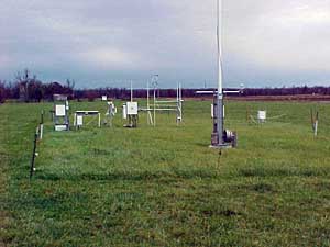
There are 23 extended facilities distributed evenly throughout the 55,000-square-mile Southern Great Plains (SGP) domain and at its corners. These instrumentation systems are intended to furnish data streams that will facilitate the spatial integration of the surface heat, moisture, and momentum fluxes across the SGP designated area. The extended facility units include an eddy correlation (ECOR) surface flux station, broadband radiometers, a Multifilter Rotating Shadowband Radiometer (MFRSR), and a Surface Meteorological Observation System (SMOS).
View an overview map of the SGP site or scan the geographic information table.
Instruments
Current list of Extended Facility instruments.
Maps
- Ashton EF-9
- Byron EF-11
- Cement EF-26
- Coldwater EF-8
- Cordell EF-22
- Cyril EF-24
- Earlsboro EF-27
- El Reno EF-19
- Elk Falls EF-7
- Halstead EF-5
- Hillsboro EF-2
- Lamont EF-13
- Larned EF-1
- LeRoy EF-3
- Meeker EF-20
- Morris EF-18
- Okmulgee EF-21
- Pawhuska EF-12
- Plevna EF-4
- Ringwood EF-15
- Towanda EF-6
- Tyro EF-10
- Vici EF-16