


 SGP Boundary Facility
The ARM Program deploys specialized remote sensing instruments in a fixed location at the site to gather atmospheric data of unprecedented quality, consistency, and completeness. More than 30 instrument clusters have been placed around the site; the central facility; and the boundary, intermediate, and extended facilities. The locations for the instruments were chosen so that the measurements reflect conditions over the typical distribution of land uses within the site.
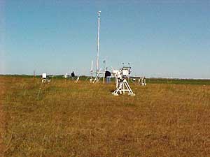
The Southern Great Plains site forms a rectangle with each of the four boundary facilities-located at Hillsboro, Kansas; Morris, Oklahoma; Purcelll, Oklahoma and Vici, Oklahoma (north, east, south and west, respectively), marking the approximate midpoint of each side of the domain. The boundary facilities were designed to establish general, large-scale motions of the atmosphere passing through the SGP locale. The instrumentation is fairly limited and provides measurements of cloud properties and wind, temperature and water vapor profiles. These domain boundary measurements are of particular value to the single-column modeling (SCM) and four-dimensional data assimilation strategies being pursued by the ARM Program.
View an overview map of the SGP site or scan the geographic information table.
Instruments
Current list of Boundary Facility instruments.