The Land
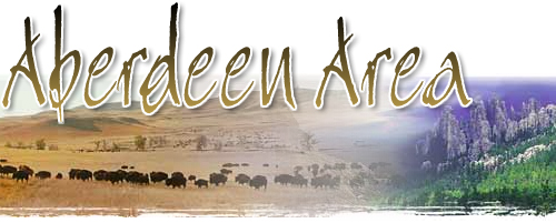
The three-state area offers incredible diversity of climate, terrain, and population. Fields of wheat and corn shift from undisturbed prairie to the rugged beauty of the Badlands and the rustic majesty of the Black Hills. Small rural communities coexist with the relatively cosmopolitan cities of Sioux Falls, Rapid City, Omaha, and Bismarck. The great lakes of the dammed Missouri have become as well known as the natural glacial lakes. The contrasts are as endless as the beauties and challenges of the area.
The Sioux Indians called these mountains "Paha Sapa" (Black Hills) because of the dark appearance of the spruce and pine forests from a distance. Black Hills National Forest and Custer State Park are unspoiled by commercial development and include the Needles; Pactola and Sheridan Lakes; the nation's largest buffalo herd; and Harney Peak, the tallest mountain east of the Rockies. The striking granite cliffs of the Hills inspired Gutzon Borglum to carve Mount Rushmore and Korczak Ziolkowski to begin his carving of Crazy Horse. Other geological attractions include Wind Cave National Park and Jewel Cave National Monument.
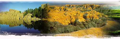
The unique outlines of the Badlands were created by 35 million years of wind and water erosion. The area boasts a sparseness of both population and rainfall. Ranches are often several thousand acres in this harsh but beautiful land. The Badlands are replete with gradiated shades of color in the striped layers of soil and the brilliant hues of wildflowers in spring and summer. Numerous fossils have been discovered in the Badlands, including three-toed horses and saber-toothed tigers. The White River Badlands in South Dakota are the site of the Badlands National Monument, and North Dakota has spectacular badlands on the Little Missouri River.
Expanses of rolling grassland still show evidence of the vast herds of buffalo which once roamed the fenceless plains. Much of the prairie has been converted into productive farmland. Other ranges of grassland are purely cattle country, untouched by the plow, and still managed by cowboys on horseback. Wildlife is abundant here. Deer, antelope, and coyotes are frequently seen, and the prairie is famous for its ring-neck pheasant population.

The great Missouri River divides North and South Dakota into east and west and forms part of the Nebraska border. The Missouri was once an artery of transportation. The need for flood control and hydroelectric power resulted in four major dams on the waterway, which transformed the waters of the Missouri into a sparkling deep blue and created four large lakes. The lakes (Lake Oahe, Lake Sharpe, Lewis and Clark Lake, and Lake Sakakawea) are a haven for water recreation and have become renowned for catches of walleye, sauger, land-locked salmon, and the strange prehistoric paddlefish.
During the Pleistocene Epoch, huge glaciers pushed southward as far as the Missouri River. These masses of ice wrinkled the land into rolling hills and rolled along on top of the rocks which remained to dot the fields of homesteading farmers. They also gouged out the lake beds that form over 100 glacial lakes in Northeastern South Dakota. Big Stone Lake and Lake Traverse are two of the more notable. Both lakes consistently produce excellent fishing and are a prime habitat for ducks and geese.
|