Kyle was a small, short-lived tropical storm
that formed over the northwestern Caribbean Sea in mid-October. It moved
onshore near the border of Guatemala and Honduras as a weakening
tropical depression
and quickly dissipated. There were no significant effects on land associated with this system.
a. Synoptic History
Satellite imagery and rawinsonde data show that a
tropical wave moved off the west
coast of Africa on 27 September. The wave was tracked in satellite imagery to the
Lesser Antilles on 5 October and to the western Caribbean Sea on the 9th where it
interacted with a frontal cloud band. Surface analysis indicated a broad 1010 mb low
over the northwest Caribbean Sea at 0000 UTC 11 October. At this time, anticyclonic
flow aloft was seen in animation of satellite imagery above disorganized convective activity.
A well-defined convective cloud band developed and post-analysis suggests that a
tropical depression formed from the disturbance near 1200 UTC 11 October while
centered about midway between Swan Island and the coast of Belize
(Fig. 1 (30K GIF) and Table 1).
Steering currents were weak and the depression began drifting toward the southwest.
The tropical cyclone
quickly intensified and is estimated to have become a tropical
storm at 1800 UTC on the 11th. A small central dense overcast was evident in satellite
imagery by the time the first reconnaissance aircraft investigated the
cyclone during the afternoon. Maximum
sustained surface winds of 45 knots are estimated to have
occurred from 1800 UTC on the 11th to 0000 UTC on the 12th. The minimum central
pressure of 1001 mb occurred near this time.
Upper-level southwesterly shear soon increased, resulting in a decrease of the deep
convection. It is estimated that Kyle weakened to a tropical depression by 1200 UTC 12 October. The
center of the rapidly dissipating
depression moved onshore near the border between Guatemala and Honduras six hours later.
b. Meteorological Statistics
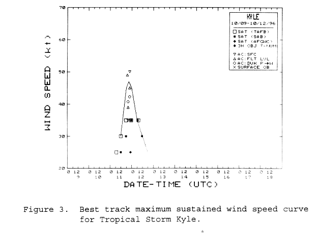
Figures 2 (20K GIF) and 3
(21K GIF) show the curves of minimum central pressure and maximum one-minute wind speed,
respectively, versus time, along with the observations on which they are based.
The limited aircraft data on 11 October were supplied by the
Hurricane Hunters
of the U.S. Air Force Reserves.
The satellite estimates were provided
by the NESDIS
Synoptic Analysis Branch, the
TPC's Tropical Analysis and Forecast Branch
and the Air Force Global Weather Center.
The maximum wind speed recorded from aircraft in Kyle was
49 knots from a flight level
of 1500 feet at 1908 UTC 11 October. The minimum observed central pressure
was 1001 mb at 2145 UTC on the 11th, and was extrapolated from 1500 feet.
Satellite estimates never exceeded T2.5 (35 knots)
on the Dvorak scale.
c. Casualty and Damage Statistics
No reports of casualties or damages were received by the NHC.
d. Forecast and Warning Critique
Kyle was a tropical storm for less than 24 hours, so a meaningful quantitative
evaluation of forecast accuracy could not be made.
Table 2 lists the watches and warnings issued or "recommended"
during Kyle. The word recommended was used in NHC advisories due to the inability to communicate
with Guatemala during the event.
Table 2. Watch and warning summary, Tropical Storm Kyle, October 1996
Date/Time
(UTC) | Action | Location |
| 11/2100 | tropical storm warning |
Felipe Carrillo Puerto, Mexico to Cabo Camaron, Honduras including Belize and adjacent islands
(Guatemala section"recommended") |
| hurricane watch |
Felipe Carrillo Puerto, Mexico to the Guatemala/Honduras border
(Guatemala section "recommended") |
| 12/1200 | hurricane watch discontinued |
Felipe Carrillo Puerto, Mexico to the Guatemala/Honduras border |
| 12/1500 | tropical storm warning discontinued |
Felipe Carrillo Puerto, Mexico to Cabo Camaron, Honduras including Belize
and adjacent islands |
![[NCEP Logo]](graphics/ncep.gif)