Michael was a short-lived category two hurricane (on the Saffir-Simpson
Hurricane Scale) that developed from subtropical origins off the northeast
coast of Florida. Michael moved northeastward over the western and northern
Atlantic as a tropical cyclone and eventually crossed Newfoundland as a
strong extratropical low pressure system.
a. Synoptic History
The precursor low pressure system that eventually became Hurricane Michael
developed as a result of an upper-level cold low that migrated southward
from the mid-latitudes and interacted with a stationary front over the
southeast Bahama Islands. A cold front pushed off the southeast U.S. coast
on 7 October and moved slowly southeast for the next couple of days before
it became stationary from near Bermuda to central Cuba on 10 October. High
amplitude mid-latitude flow in the upper-troposphere allowed a cold low to
drop southward just off the Florida east coast, which induced the formation
of a surface low along the southern end of the front east of the central
Bahamas on 12 October. The pressure gradient between the developing surface
low and high pressure anchored over the eastern U.S. created an area of gale
force winds several hundred miles northwest of the low center. The surface
low remained nearly stationary for more than 24 hours before drifting slowly
north-northeastward late on the 13th. On 14 October, the low
deepened from 1010 mb to 1003 mb and moved north to a position about 800 n
mi east of Cape Canaveral, FL. After remaining nearly stationary again for
almost 24 h, the surface low turned westward and moved underneath the
upper-level cold low on 15 October, and then stalled again about 650 n mi
east of Jacksonville, FL, as a subtropical depression. Later that day,
satellite classifications using the Hebert-Poteat technique indicated the
pre-Michael low pressure system had strengthened into a subtropical storm.
After remaining nearly stationary for an additional 48 h over very warm
sea-surface temperatures (> 28° C), thunderstorms
developed and persisted near the low-level center, which allowed the system
to gradually acquire tropical characteristics.
Prior to tropical cyclone development, Dvorak satellite intensity estimates
from the Tropical Analysis and Forecast Branch (TAFB), the Satellite
Analysis Branch (SAB), and the Air Force Weather Agency (AFWA) indicated
subtropical cyclone classifications as high as ST 2.5 or 35 kt (from the
TAFB). However, by 0000 UTC, 17 October, satellite classifications suggested
the low pressure system had acquired enough tropical characteristics to
become Tropical Storm Michael. The transition from a subtropical to a
tropical system was further supported by an earlier Advanced Microwave
Sounder Unit (AMSU) satellite overpass, which indicated a weak warm core
aloft and upper-level outflow had developed. Two QuikSCAT overpasses on the
16th also showed the radius of maximum winds had contracted from
150 n mi to less than 60 n mi between 1029 and 2252 UTC.
Later that day, U. S. Air Force Reserve (USAFR) reconnaissance aircraft
indicated that Michael had strengthened based on 1500 ft flight-level wind
reports of 60 kt and 990 mb surface pressure at 1717 UTC, and 72 kt and 988
mb pressure at 1906 UTC. Those values correspond to surface wind speed
estimates of 51 kt and 61 kt, respectively, using a standard reduction of
0.85 for that altitude. Also, experienced hurricane hunter personnel
estimated surface winds of 70 kt. Based on the reconnaissance data, it is
estimated that Michael became a hurricane at 1800 UTC, 17 October. By 0615
UTC, 18 October, reconnaissance aircraft noted a 20 n mi circular closed eye
at 850 mb, and observed a minimum surface pressure of 984 mb and
flight-level winds of 73 kt. There were slight fluctuations in the
flight-level winds and surface pressures for the next 36 hours until
rapidly deepening occurred on the 19th. As Michael began to
interact with the approaching strong mid-tropospheric trough, baroclinic
effects may have played a role in Michael's 21 mb pressure drop from 986 mb
at 1200 UTC to 965 mb at 1800 UTC. During the rapid deepening phase, the
maximum flight-level wind and minimum pressure observed by reconnaissance
aircraft was 95 kt (1500 ft) at 1829 UTC, from the NOAA Aircraft Operations
Center (NAOC), and 979 mb from the USFAR, respectively, on 18 October.
Reconnaissance flights into Michael ceased after 1957 UTC on 19 October, and
subsequent surface pressure and wind reports were obtained from ships,
buoys, and land stations. While Michael was a tropical cyclone, the lowest
pressure and maximum surface wind observed were 965.5 mb and 80 kt,
respectively, which came from ship 3EHR6 (MSC Xingang) near the
eastern eyewall at 1700 UTC, 19 October. By 2100 UTC, 19 October, a sharp
shortwave trough embedded in strong southwesterly mid-level flow accelerated
Michael northeastward toward a surface cold front. Surface data reports
indicate merger with the front occurred about 100 n mi southwest of Harbour
Breton, Newfoundland. The increasing vertical shear also likely played a
role in the extratropical transition.
During landfall along the south coast of Newfoundland as an extratropical
system, maximum sustained winds of 69 kt with gusts to 93 kt and a minimum
pressure of 967.7 mb were reported near Sagona Island. A few hours prior to
landfall, a Canadian reconnaissance aircraft observed an unofficial wind
speed of 136 kt at the top of the boundary layer. However, the cool
(4o to 10o C) and very stable boundary layer likely
prevented those strong winds from mixing down to the surface. Radar imagery
(Fig. 4) at 2145 UTC, 19 October, from Holyrood,
Newfoundland, indicated a well-defined eye at 1.5 km AGL. However, surface
observations and visible satellite imagery indicated that the position of
the radar eye was located about 75 n mi northeast of the surface position.
Decoupling of the mid- and upper-level circulation from the low-level center
further indicates that Michael was rapidly becoming extratropical.
b. Meteorological Statistics
Observations in Michael (Figure 2 and
Figure 3) include satellite-based Dvorak
technique intensity estimates from TAFB, SAB, and AFWA. In addition,
flight-level observations are available from flights of the USAFR
53rd Weather Reconnaissance Squadron and the NAOC.
Table 2 and Table 2a
consist of all ship and buoy reports, respectively, of
tropical storm force winds (> 34 kt) associated with Hurricane
Michael. During and after landfall as an extratropical low pressure system,
the Environment Canada Weather Service reported surface winds in excess of
50 kt (mainly along and east of the storm track) and pressures below 975 mb
over nearly all of Newfoundland between 2100 UTC, 19 October, and 0600 UTC,
20 October. However, the Environment Canada Weather Service did not
considered it particularly unusual since "...those communities are no
strangers to such winds."
c. Forecast and Warning Critique
The average official track errors for Michael (with the number of cases in
parentheses) were 63 (11), 133 (11), 202 (8), 247 (7), and 299 (4) n mi for
the 12, 24, 36, 48 and 72 h forecasts, respectively. These errors are
greater than the average official track errors for the 10-yr period
1990-1999 (46, 85, 122, 158, and 235 n mi, respectively) at all times. All
available forecast guidance was much better than the official forecast
except for the CLIPER (CLImatological and PERsistence) model, which
indicates that the official forecasts showed some skill. The primary reason
for the large errors were due to forecasting a slower and more northward
track, which was behind and to the left of the majority of the forecast
models. Part of the left-bias in the forecast was an expected quick
transition to and merger with an approaching extratropical low pressure
system.
Average official intensity errors for Michael were 11, 14, 21, 25, and 25 kt
for the 12, 24, 36, 48, and 72 h forecasts, respectively. Like the track
errors, the intensity errors are greater than the average official errors
for the 10-yr period 1990-1999 (7, 11, 13, 16, and 19 kt, respectively), and
were under-forecasts at all times, especially from 24 to 72 h. The first few
forecasts kept Michael below hurricane strength, while latter forecasts
weakened Michael too quickly to a tropical storm. The SHIPS intensity
forecast model had similarly poor intensity forecasts.
No tropical cyclone-related watches or warnings were issued for Michael
owing to the expected transition from a tropical to an extratropical cyclone
before making landfall at Newfoundland. However, the Environment Canada
Weather Service did issue a suite of non-tropical public wind advisories and
other products well in advance of Michael's landfall.
d. Casualty and Damage Statistics
There were no reports of injuries or deaths as Michael traversed
Newfoundland as an extratropical low pressure system. Tree and structural
damage on Newfoundland was reported as being light. Damage was confined
mainly to home roofs and siding, and trees being downed.
Table 1.
Best track for Hurricane Michael, 17-19 October 2000.
Date/Time
(UTC) | Position |
Pressure
(mb) |
Wind Speed
(kt) | Stage |
| Lat. (°N) | Lon. (°W) |
| 15 / 1200 | 30.0 | 71.2 | 1007 | 30 | subtropical depression |
| 15 / 1800 | 30.0 | 71.5 | 1006 | 30 | " |
| 16 / 0000 | 29.9 | 71.8 | 1005 | 35 | subtropical storm |
| 16 / 0600 | 29.9 | 71.9 | 1005 | 35 | " |
| 16 / 1200 | 29.7 | 71.7 | 1005 | 35 | " |
| 16 / 1800 | 29.8 | 71.4 | 1004 | 35 | " |
| 17 / 0000 | 29.9 | 71.1 | 1003 | 35 | tropical storm |
| 17 / 0600 | 29.8 | 71.0 | 1000 | 45 | " |
| 17 / 1200 | 29.8 | 70.9 | 995 | 55 | " |
| 17 / 1800 | 30.1 | 70.9 | 988 | 65 | hurricane |
| 18 / 0000 | 30.4 | 70.9 | 988 | 65 | " |
| 18 / 0600 | 30.8 | 70.8 | 986 | 65 | " |
| 18 / 1200 | 31.5 | 70.4 | 984 | 65 | " |
| 18 / 1800 | 32.6 | 69.5 | 979 | 70 | " |
| 19 / 0000 | 34.2 | 67.8 | 983 | 75 | " |
| 19 / 0600 | 36.3 | 65.5 | 986 | 65 | " |
| 19 / 1200 | 39.8 | 61.6 | 979 | 75 | " |
| 19 / 1800 | 44.0 | 58.5 | 965 | 85 | " |
| 20 / 0000 | 48.0 | 56.5 | 966 | 75 | extratropical |
| 20 / 0600 | 50.0 | 56.0 | 966 | 70 | " |
| 20 / 1200 | 51.0 | 53.5 | 968 | 65 | " |
| 20 / 1800 | 52.0 | 50.5 | 970 | 60 | " |
| 21 / 0000 | | absorbed by extratropical low |
| |
| 19 / 1800 | 44.0 | 58.5 | 965 | 85 | minimum pressure |
Table 2.
Ship reports with winds of at least 34 kt for Hurricane Michael, 17-19 October 2000.
Date/Time
(UTC) |
Ship call sign |
Lat. (°N) |
Lon. (°W) |
Wind
dir/speed
(deg/kt) |
Pressure
(mb) |
| 16 / 0600 | 3ESU8 | 28.9 | 69.9 | 160/33 | 1007.0 |
| 17 / 1800 | WGJT | 26.1 | 75.3 | 310/37 | 1012.7 |
| 18 / 1500 | VVML | 32.2 | 67.9 | 180/35 | 1014.3 |
| 18 / 1500 | WPGJ | 30.9 | 70.7 | 270/36 | 1004.5 |
| 18 / 1800 | VVML | 32.0 | 68.2 | 180/45 | 1002.3 |
| 18 / 1800 | WPGJ | 31.7 | 71.0 | 310/35 | 1015.0 |
| 18 / 2100 | VVML | 31.8 | 68.4 | 220/50 | 1004.8 |
| 19 / 0000 | LAVY4 | 34.9 | 67.4 | 120/37 | 999.0 |
| 19 / 0000 | VVML | 31.8 | 68.7 | 290/40 | 1009.3 |
| 19 / 0000 | ZCBU8 | 44.0 | 64.2 | 110/47 | 1020.0 |
| 19 / 0300 | LAVY4 | 34.8 | 68.3 | 340/36 | missing |
| 19 / 0600 | ZCBU8 | 43.3 | 66.2 | 110/68 | 1008.0 |
| 19 / 0900 | CY533 | 43.8 | 60.6 | 090/45 | 1004.4 |
| 19 / 1200 | 3FML3 | 41.4 | 55.0 | 180/39 | 1010.6 |
| 19 / 1200 | 3FRY9 | 38.1 | 60.4 | 180/57 | 1001.0 |
| 19 / 1200 | CY533 | 43.8 | 60.6 | 130/37 | 998.7 |
| 19 / 1200 | WPWH | 39.6 | 56.3 | 180/35 | 1010.0 |
| 19 / 1200 | WRYX | 38.0 | 58.0 | 170/42 | 1007.0 |
| 19 / 1700 | 3EHR6 | 43.0 | 59.4 | 180/80 | 965.5 |
| 19 / 1800 | 3FRY9 | 38.2 | 58.5 | 260/38 | 1006.8 |
| 19 / 1800 | C6FI9 | 43.3 | 60.3 | 270/40 | 974.0 |
| 19 / 1800 | WPWH | 39.8 | 58.4 | 250/38 | 1001.8 |
| Extratropical |
| 19 / 2100 | C6FI9 | 43.2 | 61.1 | 270/45 | 990.0 |
| 20 / 0000 | C6FI9 | 43.2 | 61.7 | 270/35 | 1003.0 |
| 20 / 0000 | MZGK7 | 44.3 | 55.9 | 220/52 | 991.5 |
| 20 / 0000 | V7AP7 | 40.0 | 54.1 | 210/37 | 1009.0 |
| 20 / 0000 | VCRT | 46.1 | 50.5 | 180/48 | 992.0 |
| 20 / 0000 | VCRZ | 46.1 | 59.5 | 320/43 | 986.7 |
| 20 / 0600 | 3EHR6 | 42.6 | 63.3 | 300/35 | 1010.0 |
| 20 / 0600 | C6FI9 | 43.1 | 63.4 | 270/40 | 1011.0 |
| 20 / 0600 | MZGK7 | 44.7 | 58.1 | 250/46 | 998.4 |
| 20 / 0600 | VCRT | 46.2 | 52.0 | 230/58 | 987.0 |
| 20 / 0600 | VCRZ | 46.9 | 59.5 | 300/39 | 995.7 |
| 20 / 1200 | 8PNK | 44.5 | 60.5 | 290/35 | 1009.3 |
| 20 / 1200 | LAQT2 | 42.1 | 54.0 | 270/40 | 1008.3 |
| 20 / 1200 | MZGK7 | 44.5 | 60.7 | 280/40 | 1008.1 |
| 20 / 1200 | V7AP7 | 40.4 | 58.9 | 300/35 | 1013.0 |
| 20 / 1200 | VCRT | 46.2 | 52.5 | 250/56 | 991.0 |
| 20 / 1500 | G3130 | 51.1 | 58.5 | 330/34 | 993.9 |
| 20 / 1800 | G3130 | 51.1 | 58.5 | 330/35 | 997.9 |
| 20 / 1800 | SHIP | 40.5 | 50.0 | 270/35 | 1011.5 |
| 20 / 1800 | V7AP7 | 41.7 | 60.5 | 270/37 | 1016.0 |
| 20 / 1800 | VCRT | 46.2 | 53.2 | 270/60 | 996.0 |
| 20 / 1800 | ZCAH2 | 40.6 | 50.0 | 270/35 | 1011.5 |
Table 2a.
Buoy reports with winds of at least 34 kt for Hurricane Michael, 17-19 October 2000.
Buoy Call Sign
|
Date/ Time
(UTC) |
Lat. (°N) |
Lon. (°W) |
Wind dir/speed
(deg/kt) |
Pressure
(mb) |
| 17 / 0000 | 41503 a | 26.2 | 73.0 | 270/43 | 1011.9 |
| 17 / 0000 | 41505 a | 26.7 | 65.1 | /46 | missing |
| 18 / 0000 | 41501 a | 27.2 | 71.9 | 290/45 | 1012.2 |
| 18 / 1200 | 41501 a | 27.1 | 71.9 | 250/43 | 1013.6 |
| 19 / 1800 | 44139 b | 44.3 | 57.4 | 140/43 | 983.5 |
| 19 / 2100 | 44255 b | 47.3 | 57.4 | 040/37 | 976.1 |
| 20 / 0000 | 44139 b | 44.3 | 57.4 | 230/43 | 992.0 |
| 20 / 0300 | 44139 b | 44.3 | 57.4 | 260/35 | 998.4 |
a = drifting buoy
b = 10-min average wind; moored buoy
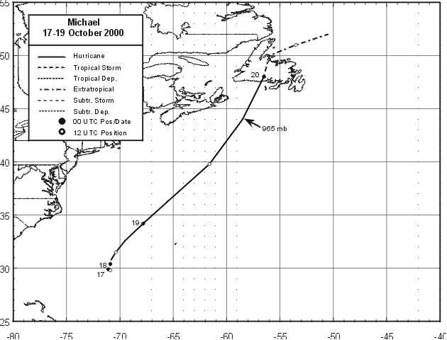
Figure 1.
Best track positions for Hurricane Michael. Track during the extratropical
stage is based on analyses from the NOAA Marine Prediction Center and
Environment Canada weather service. Subtropical positions on 15-16 October
are very close to the 17-18 October tropical positions due to the system
being nearly stationary.
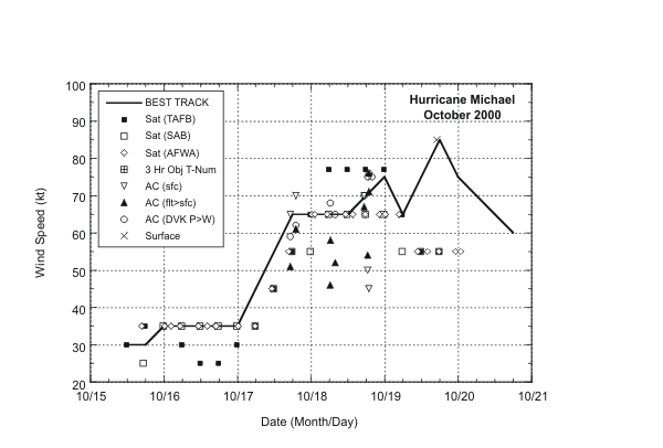
Figure 2.
Best track maximum sustained surface wind speed curve for Hurricane Michael,
and the observations on which the best track curve is based. Aircraft
observations have been adjusted for elevation using 80 percent and 85
percent reduction factors for observations from 850 mb and 1500 ft,
respectively. Estimates during the extratropical stage are based on
analyses from the NOAA Marine Prediction Center and Environment Canada
weather service.
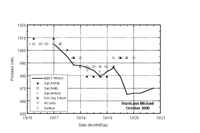
Figure 3.
Best track minimum central pressure curve for Hurricane Michael, and the
observations on which the best track curve is based. Estimates during the
extratropical stage are based on analyses from the NOAA Marine Prediction
Center and Environment Canada weather service.
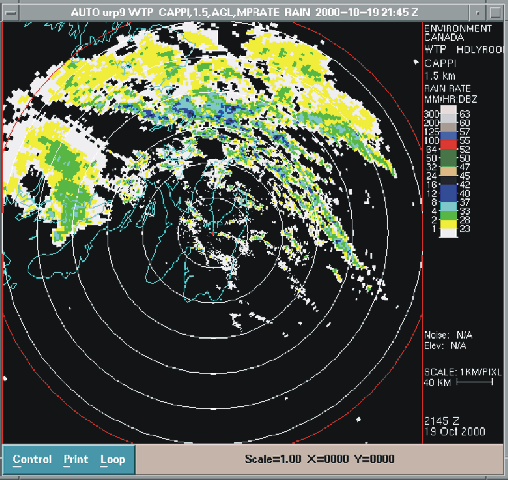
Figure 4.
Holyrood, Newfoundland (WTP) 1.5 km AGL Constant Altitude Plan Position
Indicator (CAPPI ) image at 2145 UTC, 19 October 2000. Eye is located
west-northwest near the fifth range ring (285°/210 km). Surface position of
Michael was located west-southwest of the radar site off the edge of the
display (image courtesy of the Environment Canada weather service).
![[NCEP Logo]](graphics/ncep.gif)


