Joyce was an 80-knot hurricane east of the Windward Islands, but was
weakening from a tropical storm to a depression when it passed through the
Windward Islands.
a. Synoptic history
Joyce emerged from the coast of Africa as a poorly organized tropical wave
on 22 September. This was several days behind Isaac. But while Isaac moved
northwestward and became a powerful recurving hurricane, Joyce remained far
to the south. Joyce moved on an undulating, but generally westward track at
12 to 16 kt for its entire existence. Its center remained south of 13
degrees north latitude, under the influence of a strong ridge to the north
that built westward in the wake of Isaac.
The tropical wave showed signs of a closed low-level circulation on 25
September while located about 350 n mi southwest of the Cape Verde Islands.
These signs were evident on visible Meteosat images and on SSM/I and TRMM
microwave images. In contrast, a QuikSCAT pass on the 25th showed
a shear line rather than a well-defined closed circulation. With the
preponderance of the evidence in favor of a closed circulation, the "best
track" begins with a tropical depression at 1200 UTC on the 25th.
Best track positions are plotted in
Figure 1 and Figure 2 and
Figure 3 show plots of
best-track wind speed and pressure curves as a function of time, along with
the data on which they are based. Table 1
lists best track position,
maximum one-minute surface wind speed, and minimum central sea-level pressure
at six-hour intervals.
Convection associated with the depression became better organized with
banding features. The cyclone is estimated to have become Tropical Storm
Joyce at 0000 UTC on the 26th, although there is considerable
uncertainty about this, as a QuikSCAT pass on the 27th still
showed an open wave. Strengthening continued and Joyce is estimated
to have reached its maximum intensity of 80 kt early on the 28th,
while located midway between Africa and the Lesser Antilles. This was soon
after the appearance of a short-lived "pinhole" eye feature on a TRMM pass.
Visible satellite imagery later on the 28th showed the center
partially exposed to the southwest of the deep convection, implying an
increase in vertical shear. With occasional bursts of convection, Joyce's
convective cloud pattern gradually became disorganized. Joyce weakened to a
tropical storm on the 29th and moved across the Windward Islands
and into the Caribbean Sea on 1 September while weakening from a storm to a
depression.
Joyce quickly and somewhat unexpectedly deteriorated to an open wave on 2
September while located in the southeastern Caribbean Sea just north of
Venezuela. Data from NOAA aircraft GPS dropsondes on the 30th and satellite
imagery suggest that a mechanism responsible for the above weakening was the
entrainment of lower-tropospheric dry Saharan air into Joyce's circulation.
b. Meteorological statistics
There were two USAF reconnaissance flights into Joyce on 1 October, just
before and after the center moved across the Windward Islands. Data from
these flights indicated that Joyce was a weakening, minimal tropical storm.
A third flight on the 2nd confirmed that Joyce was an open wave.
Otherwise, satellite data were the basis for all determinations concerning
the best track, including the maximum wind speed of 80 kt.
The highest surface winds reported were from Barbados: sustained 30 kt with
gusts to 40 kt. Joyce's center passed about 120 n mi south of that island.
The center of the storm passed close to Tobago and winds there backed from
north-northwest to south to east over about a 24-hour period. Maximum
sustained winds reported from Tobago were 26 kt.
c. Casualty and damage statistics
There were no reports of death or damage.
d. Forecast and warning critique
Official track forecast errors ranged from 67 n mi at 24 hours (19 cases) to
129 n mi at 48 hours (15 cases) to 208 n mi at 72 hours (11 cases). These
errors are 10 to 20 percent less than the average official errors for the
previous ten years. There was a northward bias to these forecasts, which
might be expected with a track that is a statistical outlier in terms of it
being located so far south.
Intensity errors were rather large. On 28 September, while Joyce was
located about 1000 n mi east of the Windward Islands, the wind speed was
forecast to go from an initial value of 75 knots to 95 knots in 72 hours, an
over-forecast of 60 kt. The average 72-hour bias for 11 forecasts was +31
kt, compared to an average bias of +19 kt for the previous ten years. Even
the forecast that was issued six hours before Joyce dissipated called for 60
kt at 72 hours. This large official positive bias may be partially
explained by the unexpected dissipation described in section a. above along
with a reliance on the SHIPS intensity model guidance which had an even
larger positive bias...+34 kt at 72 hours for ten forecasts.
Table 2
lists the tropical storm watches and warnings issued for the
Windward Islands. No official reports of sustained winds to tropical storm
force were received, but may have occurred at some locations in the areas
warned, as the wind reports from Barbados were close to tropical storm force.
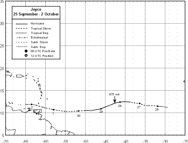
Figure 1.
Best track positions for Hurricane Joyce, 25 September - 2 October 2000.
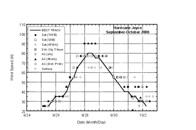
Figure 2.
Best track one-min. wind speed curve, 25 September- 2 October 2000. Aircraft
observations have been adjusted for elevation using an 85 percent reduction
factor for observations from 1500 ft.
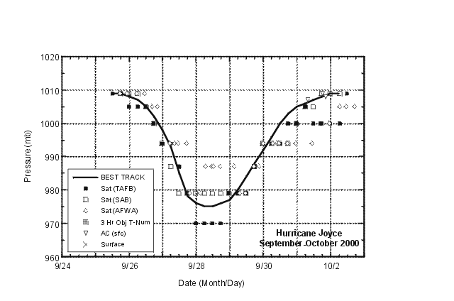
Figure 3.
Best track minimum central pressure curve for Hurricane Joyce, 25 September - 2 October 2000.
Table 1.
Best track for Hurricane Joyce, 25 September - 2 October 2000.
Date/Time
(UTC) | Position |
Pressure
(mb) |
Wind Speed
(kt) | Stage |
| Lat. (°N) | Lon. (°W) |
| 25/1200 | 11.2 | 29.6 | 1009 | 25 | tropical depression |
| 1800 | 11.4 | 30.7 | 1009 | 30 | " |
| 26/0000 | 11.5 | 31.9 | 1008 | 35 | tropical storm |
| 0600 | 11.6 | 33.0 | 1007 | 35 | " |
| 1200 | 11.6 | 34.1 | 1005 | 35 | " |
| 1800 | 11.7 | 35.3 | 1002 | 40 | " |
| 27/0000 | 12.1 | 36.4 | 998 | 50 | " |
| 0600 | 12.2 | 37.6 | 993 | 55 | " |
| 1200 | 12.4 | 38.8 | 985 | 65 | hurricane |
| 1800 | 12.5 | 40.1 | 978 | 70 | " |
| 28/0000 | 12.4 | 41.3 | 976 | 75 | " |
| 0600 | 12.2 | 42.5 | 975 | 80 | " |
| 1200 | 11.7 | 43.8 | 975 | 80 | " |
| 1800 | 11.3 | 45.0 | 976 | 75 | " |
| 29/0000 | 10.9 | 46.1 | 977 | 75 | " |
| 0600 | 10.7 | 47.2 | 980 | 70 | " |
| 1200 | 10.5 | 48.6 | 984 | 65 | " |
| 1800 | 10.5 | 50.1 | 988 | 60 | tropical storm |
| 30/0000 | 10.4 | 51.7 | 992 | 55 | " |
| 0600 | 10.3 | 53.3 | 996 | 50 | " |
| 1200 | 10.3 | 54.9 | 1000 | 45 | " |
| 1800 | 10.5 | 56.6 | 1003 | 40 | " |
| 01/0000 | 10.7 | 58.0 | 1005 | 40 | " |
| 0600 | 11.0 | 59.5 | 1006 | 35 | " |
| 1200 | 11.3 | 60.9 | 1007 | 35 | " |
| 1800 | 11.7 | 62.3 | 1008 | 30 | tropical depression |
| 02/0000 | 11.9 | 63.5 | 1009 | 30 | " |
| 02/0600 | 11.9 | 64.9 | 1009 | 25 | " |
| |
| 0600 | 12.2 | 42.5 | 975 | 80 | minimum pressure |
| 1200 | 11.7 | 43.8 | 975 | 80 | minimum pressure |
Table 2.
Watch and warning summary, Hurricane Joyce, 25 Sept. - 2 Oct. 2000.
Date/Time
(UTC) |
Action |
Location |
| 30/0900 |
tropical storm watch issued |
Barbados, St. Vincent, the Grenadines, Trinidad, Tobago, Grenada and its dependencies. |
| 30/1000 |
tropical storm watch issued |
St. Lucia |
| 30/1500 |
tropical storm warning issued |
Trinidad, Tobago, Grenada and its dependencies. |
| 01/0600 |
tropical storm warning downgraded to watch |
Trinidad |
| 01/1200 |
tropical storm watch discontinued |
Barbados, St. Vincent |
| 01/1500 |
tropical storm watch discontinued |
Trinidad, St. Lucia |
| 01/1500 |
tropical storm warning discontinued |
Tobago |
| 01/2100 |
tropical storm warning discontinued |
Grenada and its dependencies |
![[NCEP Logo]](graphics/ncep.gif)


