Chapter 6: Exposure Evaluation: Evaluating Exposure Pathways
- Section 6.1 defines exposure pathways and identifies the five elements of a
pathway.
- Sections 6.2 through 6.5 outline considerations for evaluating these five elements.
- Section 6.6 offers guidance on how to make an overall judgment on a given
exposure pathway: Is a pathway completed or potential? Can it be eliminated from
analysis altogether?
- Section 6.7 discusses exposure investigations and when they might be appropriate
for filling critical information gaps.
- Section 6.8 describes how to document information on exposure pathways in public health assessment documents.
A critical early step in the public health assessment process is evaluating exposure pathways. The goal of exposure pathway evaluations is to identify likely site-specific exposure situations and answer the questions: Is anyone at a given site exposed to environmental contamination? Under what conditions does this exposure occur?
This chapter describes how to clearly define and explain exposure pathways:
Figure 6-1 illustrates the overall process of evaluating exposure pathways. As the figure shows, health assessors typically evaluate exposure pathways before they conduct health effects evaluations (see Chapters 7 and 8). This order is logical because extensive health effects evaluations are not necessary if people are not coming into contact with environmental contamination. When reading this chapter, however, keep in mind that exposure pathway evaluations eventually inform the health effects evaluations, if they need to be performed. Specifically, thorough exposure pathway evaluations should define the points of exposure, concentrations of environmental contamination at these points, and the populations that are potentially exposed.

6.1 Exposure Pathway Evaluation
Every site presents unique challenges and exposure scenarios. The health assessor considers site-specific factors that might enhance, prevent, or modify exposures to environmental contamination. Environmental health professionals use "exposure pathways" to evaluate the specific ways in which people might come into contact with environmental contamination.
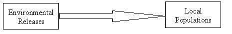
As the schematic below shows, an exposure pathway is the link between environmental releases and local populations that might come into contact with, or be exposed to, environmental contaminants. An exposure pathway evaluation, therefore, determines if site contaminants have been, are, or will be in contact with local populations. In other words, it answers the key question: Could people be exposed to site-related contaminants? Past, current, and future exposure conditions need to be considered because the elements of an exposure pathway typically change with time.
Exposure Pathway
6.1.1 The Five Elements of an Exposure Pathway
ATSDR environmental health scientists study exposures in the context of the following five exposure elements:
Element 1: The contaminant source or release. Sources may include drums, landfills, and many others which may release contaminants into various media. Refer to Section 6.2 for further information.
Element 2: Environmental fate and transport. Once released to the environment, contaminants move through and across different media and some degrade altogether. Section 6.3 describes these processes in detail.
Element 3: Exposure point or area. As Section 6.4 reviews, this is the specific location(s) where people might come into contact with a contaminated medium.
Element 4: Exposure route. The route is the means by which people physically contact environmental contamination at the exposure point (e.g., by inhalation, ingestion, or dermal contact). Section 6.4 also addresses this issue.
Element 5: Potentially exposed populations. Section 6.5 offers guidance on how to identify and characterize populations that may come or may have come in contact with contaminants.
These five elements largely determine to what extent exposures may have occurred, may be occurring, or may occur in the future at and around a site. Though you may find that some elements require more detailed evaluations than others, reviewing these elements will help you identify exposure situations that require further investigation for a public health assessment. All five elements of an exposure pathway must be present to consider that pathway "complete," as Section 6.6.1 describes. Note, however, that a complete exposure pathway does not necessarily mean that a public health hazard exists, a finding that should be communicated early. Rather, specific exposure conditions, such as the route of exposure and the magnitude, frequency, and duration of exposures need to be examined more closely to evaluate possible health implications of the exposures (see Health Effects Evaluation in Chapters 7 and 8).
Section 6.6 provides additional guidance on the three different categories of exposure pathway information commonly used in public health assessments—completed, potential, and eliminated—and how health assessors should evaluate them.
6.1.2 Developing a Site Conceptual Model
Different people have different ways of evaluating exposure pathways at their sites, but a common approach involves developing a site conceptual model, which helps you envision how people might come into contact with environmental contamination. Regardless of the site-specific nuances, developing a site conceptual model will ultimately help you visualize how contaminants move in the environment at your site and how people might come into contact with these contaminants.
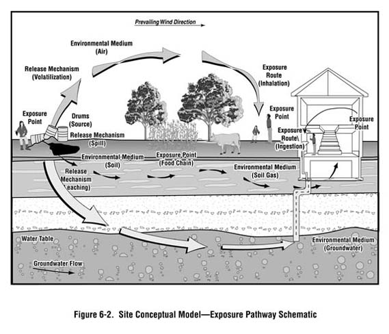
Figure 6-2 is an example of a schematic that may form the basis of a site conceptual model for a site with a pile of waste drums. The schematic indicates the various ways in which contaminants can move from the source through media to points of exposure. Naturally, the model for your site will depend entirely on site-specific conditions. For instance, if the pile of waste drums shown in Figure 6-2 were located in a lined landfill with leachate controls, contaminants likely would not enter the groundwater and move off site.
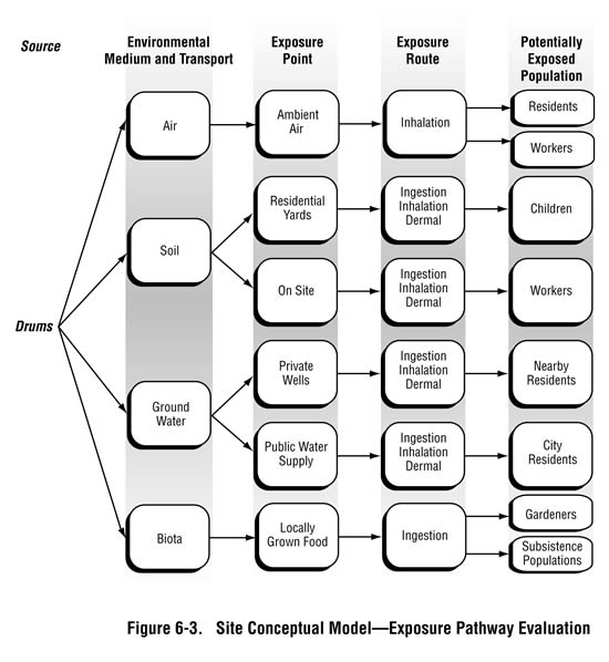
The information presented in Figure 6-3 is another way of presenting a site conceptual model for the pile of drums. This type of diagram more explicitly outlines examples of some factors you should consider when analyzing the exposure pathways at your site: What media are affected? What media transport contaminants from the source to exposure points? Where are the exposure points? What are the potentially exposed populations? Sections 6.2 through 6.5 outline the thought process for evaluating the five elements of exposure pathways, but having a detailed site conceptual model will help in these evaluations.
Developing a site conceptual model early in the public health assessment process ultimately will help you prioritize pathways evaluations. For example, consider a closed landfill site with homes immediately adjacent to the landfill. Such sites usually produce some level of both groundwater and soil gas contaminants. If information collected early in the process indicates that the municipal water supply for homes is from a reservoir located many miles away, then researching the groundwater contamination pathway is clearly not a priority. If, on the other hand, on-site soil gas measurements indicate methane levels many times above the explosive limit, the migration of flammable gases into homes would require immediate investigation. Therefore, by developing a site conceptual model early in the process, and by periodically revisiting this model, you can ensure that you address the most critical public health issues in a timely manner.
6.2 Contamination Source(s) and Releases
Exposure pathways start with a source of contamination. Section 6.2.1 defines this term and offers guidance on how to identify sources. Section 6.2.2 describes how to characterize the environmental media that sources of contamination may affect. Public health assessments need to consider both the sources of chemical public health hazards and physical public health hazards. Section 6.2.3 presents considerations for addressing physical hazards.
6.2.1 Identifying Contamination Sources
A contamination source is, as the term implies, the origin of environmental contamination. Identifying possible contamination sources helps determine what environmental media may be affected and how hazardous substances might reach populations at or near a site. Examples of contamination sources include, but are not limited to, the following:
|
|
Some sites have just one contamination source, but many sites have numerous sources. Each source represents a location—a point or area—where a release of contaminants may be occurring or may have occurred. Knowledge of a site's sources is critical because it enables you to determine whether all possible receiving media have been adequately studied. For example, if the source of contamination is a leaking underground storage tank, reviewing levels of contamination in soil, soil gas, and groundwater will be necessary to accurately determine if people are being exposed.
Sometimes, you may identify elevated contaminant levels, but may not be able to identify the original source of contamination. For example, elevated levels of lead (compared to background) may be detected in site soils but the source of the lead might not be identified. In such cases, you might conclude that a source of contamination existed at some point in the site's history, though the details of the original release might not be known. In other cases, the source of detected contamination may be upgradient of your site.
To identify possible contamination sources, health assessors review site descriptions and data from site investigation reports (e.g., RI/FS and other environmental reports) (see Chapter 3). In most cases, information on sources of contamination is well-documented in existing reports, largely because environmental investigations often are designed to conduct sampling at known or suspected source areas and in potentially affected media. Studying site plans and maps can provide additional perspective on the exact locations and possible exposure implications of contamination sources.
It is important to have information on how sources of contamination change over the years. Such insights can be gleaned from the following considerations:
- History of the site. By interviewing site contacts and local residents, reading
reports, and reviewing files on past and current site activities, you can find out
whether contaminants have been intentionally or unintentionally disposed of or
released at a particular location. More importantly, you can find out exactly when
those releases occurred and how long they persisted.
- Operating period. Simply knowing the window of time a site operated can tell
you the time period during which certain sources may have existed—a crucial
insight for determining lengths of possible exposures.
- Source controls or remedial actions. By identifying when specific control
measures or remedial actions were implemented at a site, you can gain insights on
how environmental releases have been mitigated. Examples of such controls
include landfill liners, leachate collection systems, scrubbers, wastewater
treatment systems, and baghouses. Knowing whether any cleanup actions have
taken place will also inform your evaluations of sources.
- Other contributing sources. Evaluating the potential for other sources or releases in nearby areas also provides useful perspective, particularly for air contamination. For instance, an emissions test might find that landfill vents release 10 pounds of benzene to the air in a year. If the site is in an urban area, further research would likely reveal that this emission rate is dwarfed by benzene emissions from motor vehicles, gasoline stations, and other sources.
Ultimately, you will use information on contamination sources for perspective on the types and durations of possible exposures. Keep in mind that, when identifying contamination sources, you will need to clearly indicate what is known about the type and extent of contamination at the source and at the receiving media. In addition, you should clearly state whether contamination sources have been adequately characterized, whether source areas have been remediated, and how the available information affects the ability to characterize exposures.
6.2.2 Identifying Affected Media
After identifying the contamination source, you should identify all environmental media that may serve to transport contaminants from the source(s) to possible points of human exposure. Affected media may include:
|
|
Identifying contaminated media and gaining an understanding of the nature and extent of contamination will be accomplished in various steps. You will probably start to characterize the media by studying available sampling data, reviewing detected concentrations, evaluating sampling data quality and adequacy, and making comparisons between site-related data and background data (see Section 5.3). You may also begin to gain a sense of the relative degree of contamination by comparing detected substance concentrations to media-specific comparison values (see Chapter 7).
Sampling data can be extremely useful in evaluating the media that are known to be contaminated. Sampling data collected over time can tell you how long media have been contaminated and the extent to which remediation projects have been successful at reducing levels of contamination. When media have not been adequately sampled, however, you will still need to determine whether the media have been, are currently, or may in the future become contaminated (see Section 6.3). The extent to which substances may persist in, or migrate to and through, these media depends on a number of substance- and site-specific factors. In some cases, you will find that mathematical models have been used to estimate environmental conditions at locations and times when sampling has not been conducted. Chapter 5.2 provides guidance on the usefulness of modeling in the public health assessment process.
6.2.3 Identifying Physical/Safety Hazards
Though most of this manual focuses on evaluating the public health implications of exposure to environmental contaminants, ATSDR, as a public health agency, also considers physical or safety hazards of the sites (or sources) under evaluation. In doing so, the agency helps to ensure that the health and safety of the public are protected. Various physical and safety hazards may exist at hazardous waste sites, such as: unsafe structures, dangerous or abandoned equipment, debris, accumulation of explosive and asphyxiating gases, open pits and mine shafts, confined spaces, unexploded ordnance (see text box), lagoons, and unsafe terrain. All physical threats should be considered, including threats of fire or explosion.
|
When evaluating a site, you need to identify any safety hazards that have the potential to cause harm to people working or living on or near the site. Review of site documents (including the CERCLA required site safety plan), contacts with site officials, and observations during site visits will help identify such hazards (see Chapter 3). As is true when studying any site-related hazard, you should evaluate the likelihood, if any, that people have access to unsafe areas before determining the extent to which a safety hazard exists. For example, an abandoned building may be in serious disrepair but it may pose no public safety threat if it is located inside a securely fenced, inaccessible area where no signs of trespassing (e.g., foot prints or garbage) have been observed.
ATSDR's mandate does not include the health of workers—this issue is mainly the responsibility of the Occupational Safety and Health Administration (OSHA) and the Centers for Disease Control and Prevention (CDC)/National Institute for Occupational Safety and Health (NIOSH). Exposures directly related to worker activities fall under the purview of these agencies. If workers request information on potential occupational hazards, whether chemical or physical, you should generally refer them to these agencies. However, ATSDR has limited authority to examine health issues of workers who perform remedial tasks, and the public health assessment process does consider exposures related to the environmental releases under study (e.g., worker exposure to contaminated groundwater via the drinking water supply).
6.3 Evaluating Fate and Transport of Contaminants
Fate and transport refers to how contaminants move through, and are transformed in, the environment. Evaluating fate and transport of contaminants within environmental media is the step in the exposure pathway evaluation that helps you determine if and how contaminants might move from a source area to an exposure point. The fate and transport evaluation is generally a qualitative exercise and often does not require quantitative evaluations (i.e., modeling studies) of environmental fate and transport.
You might use different types of information when evaluating fate and transport, the second element of an exposure pathway. The following categories of information may be useful for some site-specific evaluations:
- Possible transport processes that may carry a substance away from its source (see Section 6.3.1).
- Physical, chemical, and biologic factors that influence the persistence and
movement of a substance within and across environmental media, which can be
important in determining whether opportunities for human exposure may exist
(see Section 6.3.2).
- Site-specific environmental conditions such as climate and topography that determine how contaminants move through the environment at a given location (see Section 6.3.3).
The extent to which you will need to examine fate and transport issues depends on many factors, such as the availability of site-specific environmental data sets, the complexity of site issues, and community health concerns. If you have determined that the nature and extent of contamination in all relevant media have been adequately characterized after reviewing pertinent studies, little or no fate and transport evaluation may be necessary. If the fate and transport issues are difficult to determine, you should use the worst-case scenario. In other cases, a fate and transport evaluation may be required to answer questions such as: What is the likelihood of contamination migrating from a surficial aquifer to a deeper aquifer that serves as a drinking water source? What is the direction and path of a particular groundwater plume? What is the potential for soil or sediment contaminants to accumulate in plants, animals, or fish? What is the likelihood of a groundwater contaminant volatilizing and migrating via soil gas into indoor air? What is the likelihood that degradation of volatile organic compounds is producing measured contaminants?
You can often obtain pertinent fate and transport information in site investigation reports. All Superfund remedial investigation reports, for example, include chemical- and media-specific fate and transport information. When evaluating and interpreting various fate and transport information, you may need to consult technical experts (e.g., hydrogeologists, air modelers), especially when more quantitative analyses are needed to characterize affected media.
Ultimately, fate and transport evaluations should help you determine how likely it is that contaminants have moved or will move beyond the source area and how likely it is that contamination and exposure may occur beyond the sampled areas.
|
6.3.1 Fate and Transport Processes
Fate and transport are interdependent processes. Transport involves the movement of gases, liquids, and particulate solids within a given medium and across interfaces between water, soil, sediment, air, plants, and animals. Fate refers to what eventually happens to contaminants released to the environment—some fraction of the contaminants might simply move from one location to the next; other fractions might be physically, biologically, or chemically transformed; and others still might accumulate in one or more media.
When evaluating sites, you need an overall appreciation of the primary fate and transport release processes, intermedia transfer mechanisms, and transport pathways that might influence the ultimate fate of site-related contamination. Depending on site issues, understanding these basic fate and transport mechanisms may help you understand the implications for possible past and future exposures. The following questions are useful considerations for understanding how fate and transport mechanisms might influence the likelihood of exposures:
- How fast are contaminants moving?
Groundwater flow rates, for example, determine when a groundwater contamination plume may have reached downgradient private wells or may migrate to other downgradient wells in the future. - How fast are contaminants dispersing along the flow path?
In some cases, residents living far from sources of contamination express concern about potential exposures. Insights from fate and transport models can provide context for these concerns. For instance, air models (see Chapter 5) can estimate how ambient air concentrations of pollutants are expected to decrease with downwind distance from a particular emissions source. The rate of this decrease ultimately will depend on the type of source (e.g., stack or area), its release parameters (e.g., height, exit velocity), and other factors (e.g., terrain). - Where are contaminants moving in a particular medium?
Grasping the anticipated spatial variations in contamination will help you determine whether exposure points might be impacted. For instance, when evaluating a site with contaminated groundwater, you should consider the likelihood that contaminants might migrate laterally (perhaps to drinking water supply wells) or vertically (into different aquifers which may or may not be used for drinking water supply). - To what extent might natural attenuation be occurring?
Natural attenuation refers to any natural process that is known to degrade or dissipate environmental contamination. Natural attenuation processes, therefore, include biologic degradation, volatilization, and adsorption. As a site-specific example, for chemicals found at elevated concentrations in soil, you might decide that migration to exposure points is unlikely for those chemicals both with a high propensity for adsorbing to soil and with a relatively short half-life for biologic degradation. Note that some biodegration products can be equally or more toxic than their parent compounds (e.g., vinyl chloride as a byproduct of trichloroethylene). - Are contaminants entering the food chain?
Even though contaminants are essentially never released directly to fish, animals, or plants, fate and transport processes sometimes can make food chain contamination the most important public health issue for your site. For instance, though the source of contamination at a facility might be limited to its wastewater discharge of PCBs to surface water, these contaminants can biomagnify resulting in relatively high concentrations in fish at the highest level of the food chain.
Appendix E presents an overview, by environmental medium, of the various factors that can affect the fate and transport of a substance within and across environmental media.
6.3.2 Physical and Chemical-Specific Factors That Influence Environmental Fate and Transport
Sometimes your understanding of a contaminant's physical and chemical properties is sufficient to characterize fate and transport for the exposure pathway evaluations. This section briefly describes chemical and physical properties that can influence a contaminant's fate in the environment. Knowledge of these properties will enable you to understand a contaminant's behavior in the environment and can help, when necessary, to focus the assessment on transport mechanisms of possible significance. For example, chemical-specific factors can help determine whether particular pesticides detected in lake sediment are likely to accumulate in fish.
The chemical and physical properties described below, however, are the results of laboratory studies in highly controlled conditions and may not reflect accurate behavior of chemicals in uncontrolled environmental conditions. Laboratory studies usually do not reflect the multiple variables and influences found in the environment such as chemical mixtures and varying geochemical conditions of soils and geologic materials. Health assessors should not rely too heavily upon theoretical and laboratory studies to predict the fate and transport of site-specific contaminants. Site-specific environmental measurements that reveal how much and where contamination exists are always preferred.
The list below reviews some commonly cited chemical and physical properties that might help with your pathways evaluations. Further information on these and other properties that affect environmental fate and transport in different environmental media can also be found in ATSDR's Toxicological Profiles and the National Library of Medicine's TOXNET Hazardous Substances Data Bank, in addition to many other sources.
- Water solubility refers to the maximum concentration of a chemical that dissolves
in a given amount of pure water. Environmental conditions, such as temperature
and pH, can influence a chemical's solubility, which, in turn, also affects a
contaminant's volatilization from water. Solubility provides an important
indication of a contaminant's ability to migrate in the environment: highly soluble
compounds will tend to move with groundwater, while insoluble compounds do
not.
- Density of liquid refers to a liquid's mass per volume. For liquids that are
insoluble in water (or immiscible with water), liquid density plays a critical role.
In groundwater, liquids with a higher density than water (called dense non-aqueous phase liquids or DNAPL) may penetrate and preferentially settle to the
base of an aquifer, while less dense liquids (called light non-aqueous phase liquids
or LNAPL) will float.
- Vapor pressure is a measure of the volatility of a chemical in its pure state. Thus,
the vapor pressure largely determines how quickly contaminants will evaporate
from surface soils or water bodies into the air. Contaminants with higher vapor
pressures will evaporate more readily.
- Henry's Law Constant is a measure of the tendency for a chemical to pass from an
aqueous solution to the vapor phase. It is a function of molecular weight,
solubility, and vapor pressure. A high Henry's Law Constant corresponds to a
greater tendency for a chemical to volatilize to air.
- The organic carbon partition coefficient (Koc) describes the sorption affinity a
chemical has for organic carbon and consequently the tendency for compounds to
be adsorbed to soil and sediment (based on the organic carbon content of the soil
or sediment). This coefficient is often referred to as the adsorption coefficient. A
high Koc indicates that organic chemicals bond tightly to organic matter in the soil
so less of the chemical is available to move into groundwater or surface water.
- The octanol/water partition coefficient (Kow) indicates a chemical's potential to accumulate in animal fat by representing how a chemical is distributed at equilibrium between octanol and water. Contaminants with higher Kows are more likely to bioaccumulate.
- The bioconcentration factor (BCF) is a measure of the extent of chemical
partitioning at equilibrium between a biologic medium, such as fish or plant
tissue, and an external medium, such as water. This factor can be qualitatively
used to evaluate the potential for exposure via the food chain. A high BCF
represents an increased likelihood for accumulation in living tissue.
- Transformation and degradation rates take into account physical, chemical, and biologic changes in a contaminant over time.
Chemical transformation is influenced by hydrolysis, oxidation, photolysis, and biodegradation. A key transformation process for organic pollutants is aqueous photolysis (i.e., the alteration of a chemical species due to the absorption of light), often in the form of photochemical reactions (i.e., reactions in the air driven by the sunlight). The transformation rates for chemical reaction are expressed in different rates, including reaction rate constants and half-lives.
Biodegradation, the breakdown of organic compounds by microorganisms, is a significant environmental process in soil. Precise estimations of chemical-specific transformation and degradation rates are difficult to calculate and to apply because they are subject to site-specific physical and biologic variables.
Media-specific half-life provides a relative measure of the how persistent a substance might be in a particular environmental medium.
6.3.3 Site-Specific Factors That Influence Environmental Fate and Transport
Many climatic and physical factors can affect—speed up, slow down, or even stop—how contaminants transport through the environment and ultimately affect whether human exposures may occur. Obtaining this information can help you determine whether and how quickly contaminants are likely to reach points of possible exposure. For example, precipitation, topography, hydrology, hydrogeology, and soil type indicate how quickly water-soluble contaminants will enter groundwater, while temperature and other factors affect whether and how quickly contaminants will volatilize into the air.
An overview of potentially important site-specific factors is presented below. Some of the pertinent information is usually documented in site investigation reports already conducted by EPA or other regulatory agencies. See Chapter 3 for other possible sources.
Factors related to climate can be important when trying to understand the likelihood of contaminant movement in a particular setting. The following factors are a partial list of those which affect environmental fate and transport:
- Annual precipitation and evaporation rates are useful in determining the amount
of surface-water runoff, groundwater recharge rates, and soil moisture content
influencing contaminant migration at a given site. The topography of the land and
local surface water flow patterns will, of course, affect the materialization of these
properties. In addition, precipitation promotes the removal of particulates and
soluble vapors from the atmosphere.
- Temperature conditions affect the volatilization rate of contaminants: chemicals
are more likely to evaporate in warmer environments. In addition, ground
temperature can affect the movement of contaminants as frozen ground cover can
increase runoff and inhibit groundwater recharge. Also, frozen soils can increase
the lateral spread of soil gas.
- Wind speed and direction clearly influence the dispersion and volatilization of
airborne contaminants, as well as the generation rates of fugitive dust. Knowing
the prevailing wind patterns for a site can help provide a qualitative understanding
of where "downwind" locations are, increasing your ability to more accurately
evaluate potential air exposures. However, you should not rely solely on the
prevailing wind direction when identifying potentially exposed populations. For
example, prevailing wind directions may suggest areas of long-term pollutant
impact from a particular emissions source, but winds may also periodically blow
from other compass directions during certain times of the year. Therefore,
emissions may have short-term air quality impacts in all compass directions
around a site, with the extent of these impacts determined by how often a location
was downwind from the facility.
- Seasonal conditions could be a major factor affecting rates of contaminant migration where precipitation temperatures vary greatly according to the season. For example, the extent and distance of contaminant migration will be dramatically different if during a period of heavy rain versus a heavy snow.
6.3.3.2 Geologic and Hydrogeologic Conditions
Understanding site-specific conditions that affect the subsurface movement of contaminants is important in many public health assessments, largely because of concern about drinking water obtained from groundwater wells. Geologic and hydrogeologic conditions will influence how fast and in what direction contaminants in soil and groundwater might move, and ultimately if and how contaminants might reach people. These conditions should also be considered when deciding whether available sampling data are sufficient to characterize exposure points.
Some key considerations are highlighted below:
- Groundwater hydrology and geologic composition affect the direction and extent
of contaminant transport in groundwater. To understand a site's groundwater flow
patterns, you should review site reports or U.S. Geological Survey or state
geological survey data to identify groundwater flow direction, hydraulic
conductivity (water-transmitting characteristic), gradient, water table contours,
and possible discharge points (e.g., seeps, springs, surface water).
- The physical characteristics of aquifers beneath or near a site, especially the
porosity and permeability of their geologic materials, will greatly influence the
vertical and lateral movement of groundwater and contaminants. Note the
presence and continuity of aquitards (i.e., geologic layers that restrict the flow of
groundwater) and rapid recharge areas, such as sinkholes and solution channels.
Be aware that discontinuities in the aquitard, overpumping the lower aquifer,
poorly installed or maintained wells piercing the aquitard, etc., can all lead to
contaminant migration from an upper aquifer down to a "protected" lower aquifer.
- Depth to groundwater—or the depth of the water table—can be important in your
analyses. For instance, this depth is a key consideration when evaluating whether
volatile contaminants from groundwater might evaporate and migrate into indoor
air. Shallow aquifers, particularly water tables at or just below building
foundations, would clearly pose more of a threat for such a scenario than water
tables at greater depths below ground surface.
- Wells installed within aquifers can affect groundwater flow and direction.
Pumping rates of high-capacity municipal, industrial, or agricultural wells can
influence localized groundwater flow patterns, and may affect contaminant
transport in the aquifer in the area surrounding the well, sometimes referred to as
the "capture" zone.
- Soil characteristics, such as configuration, composition, porosity, permeability,
and cation exchange capacity of the soil ultimately influence the rates of
percolation (or rainwater infiltration), groundwater recharge, contaminant release,
and transport. Knowing that many contaminants tend to adsorb readily to clay
materials, for example, you might view a site with soils composed largely of clay
differently from a site with soils composed largely of sand. Regardless of soil
type, however, the greatest sorption will typically be to the organic material.
- Ground cover and vegetative characteristics of the site influence rates of soil
erosion, percolation, and evaporation. Releases to a paved surfaces may be carried
long distances by surface water runoff, while releases to soils might be confined to
a smaller area.
- Topography, the relative steepness and elevation of the site, will affect the
direction and rate of surface water runoff, the rate of soil erosion, and the potential
for flooding.
- Human-made objects, such as sewers, culverts, and drainage channels, can change the movement of contaminants.
6.4 Identifying Point(s) of Exposure and Exposure Routes
As discussed in Chapter 3, the points at which people may come in contact with site contaminants can be identified by reviewing land use and natural resource data and via community interviews and concerns. Points of exposure should be identified for each environmental medium (Section 6.4.1), as should routes by which exposure could occur (Section 6.4.2). Other considerations include examining changing conditions over time (e.g., future land use) (Section 6.4.3) and conditions that might limit or eliminate contact with contaminated media (Section 6.4.4).
6.4.1 Possible Exposure Points by Environmental Medium
Possible exposure points, by environmental medium, are summarized below. Using the resources identified in Chapter 3, identify which exposure points may be relevant to a particular site. Keep in mind that possible routes of exposure can change significantly depending on the land use at a site and in its surrounding areas.
- Groundwater. Potential exposure points include wells and springs used for
municipal, domestic, industrial, and agricultural purposes. Groundwater may also
be used as a water supply source for swimming pools and other recreational water
activities. In some areas, natural springs are used for both recreation and water
supply.
- Soil. There are several different ways in which people can come into contact with contaminated soil. The matrix in the box, below, serves as a useful framework for evaluating potential soil exposure points. Of course, you should always consider how unique site-specific scenarios might differ from the general guidelines presented. For example, some cultures consume clays or earths (called geophagy), generally from depths of 18 to more than 36 inches below the surface. While the materials consumed in this instance are primarily from known and usually uncontaminated sources, identifying such site-specific scenarios is critical in accurately defining possible exposure points (ATSDR 2001a).
|
- Surface water. Exposure points can include irrigation and public, industrial, and
livestock water supplies, so, it is particularly important to identify the location of
water supply intakes that might be downstream of a site. Surface water may also
be used for recreational activities such as swimming, fishing, and boating. Note
that recreational use of surface waters is not limited to parks and public beaches;
some residents (particularly children ages 6 to 12) may wade, swim, play, and
even fish in stormwater drainages, local streams, and local ponds. You can learn
about these uses from observations made during site visits, from interviews with
the community, and from your site contacts.
- Sediment. Sediment may serve as an exposure point for swimmers, workers, and
others coming in contact with submerged or exposed sediment. At some sites,
beaches along rivers may be important exposure points, as the sediment on the
beach may have originated from upstream locations. Sand bars, overbank flood
deposits, and other sandy areas along streams and in drainage ditches are often
attractive unofficial play areas for young children. Additionally, sediments can be
excavated and transported to other areas and used as top soils. In fact,
maintenance of ditches, drainage channels, canals, and other watercourses
throughout the United States commonly results in sediments being placed in a
variety of areas. However, current environmental regulations require that highly
contaminated sediments be handled as hazardous waste and not transported to
public use areas.
- Air. Possible exposure points involve contaminants that are volatile or adsorbed to
airborne particulates and may occur outdoors or indoors. The area downwind of a
site might be an exposure point for contaminated ambient air as a result of
volatilization or entrainment of contaminants in dust particles. The air inside
buildings near a contaminated site may also be an exposure point for indoor
airborne contaminants from migrating soil gases. Specifically, buildings on or
adjacent to landfills should be evaluated for the presence of flammable (methane)
and asphyxiating (carbon dioxide) conditions from migrating landfill gas.
- Food chain. Exposure points can be present if people consume plants, animals, or
other food products that have contacted contaminated soil, sediment, waste
materials, groundwater, surface water, or air. This may include fruits and
vegetables grown in home gardens, orchard produce, plants used for medicinal
purposes, livestock, game, and other terrestrial or aquatic organisms. In some
areas, wild plants, animals, and fish may constitute a significant portion of the diet
of local residents, possibly at the subsistence level.
- Other. Contaminated materials at commercial or industrial sites (e.g., raw materials, sludge from treatment processes, waste pilings, radiation-laden metals) may provide a direct point of contact for on-site workers, visitors, or trespassers.
Specific and clear definitions of exposure points are needed when evaluating the public health implications of exposure. For example, specify exposure points within an aquifer that have been shown to be contaminated (e.g., private wells) or locations where contaminated soil was used as fill (e.g., residential yards). In short, knowing the nature and extent of contamination at the potential exposure points is critical to conducting meaningful health effects evaluations (see Chapters 7 and 8). Also, identify what you do not know and determine whether it represents a critical data gap.
In general, individuals may be exposed to contaminants in environmental media in one or more of the following ways:
- Ingestion of contaminants in groundwater, surface water, soil, and food.
- Inhalation of contaminants in air (dust, vapor, gases), including those volatilized
or otherwise emitted from groundwater, surface water, and soil.
- Dermal contact with contaminants in water, soil, air, food, and other media, such
as exposed wastes or other contaminated material.
- External exposure to radiation. Gamma radiation is unique in comparison to chemical contaminants because it travels beyond the source. Therefore, direct contact is not necessary for exposure to occur. In fact, radiation can easily penetrate solid materials such as soils, drums, and even lead. Gamma radiation, in particular, can travel great distances before losing strength. External exposure to radiation also includes exposure to beta particles from many radioactive materials. These, too, can easily penetrate certain materials and travel several meters prior to loss in energy.
In your exposure pathway evaluation, you will need to identify which routes are viable for each exposure point. For example, if contaminated groundwater is being supplied to a household, then the residents may be exposed via ingestion (by drinking the water), inhalation (from volatilization during a shower), and dermal contact (when taking a shower or bath). It is important to ask some critical questions in determining whether or not an exposure route is viable for a population. If residents drink bottled water and use groundwater for non-potable purposes, then they are not being exposed to the contaminated groundwater through the ingestion route. At the same time, if children are using the water for bathing or swimming in a bath, shower or pool, there may be incidental ingestion. Considering all possible populations is important.
6.4.3 Temporal and Spatial Considerations
Evaluating how contamination patterns might change over time and space is important in understanding where, how, and when people might have or might come in contact with site contaminants. A geographic information system (GIS) and various modeling tools may help in capturing important temporal and spatial trends.
6.4.3.1 Temporal Considerations
Patterns of land use may change over time. Therefore, past, current, and future points of exposure need to be considered. A site may have served a number of uses (e.g., recreational, residential, agricultural, commercial, and industrial) that resulted in a variety of exposure points, depending on the contaminated media and specific time frame being examined. Because of remedial measures or other site-related activities, no current exposure points may exist. However, recognize that past exposure points may have existed and try to identify them. Likewise, consider anticipated or planned future land uses to identify possible future exposure points.
6.4.3.2 Spatial Considerations
Many elements of an exposure pathway vary with location, including levels of environmental contamination, potential exposure points, and receptor populations. A GIS can be a valuable tool for analyzing these elements simultaneously and generating visual representations of data. For instance, GIS analysts can create maps with multiple layers that depict different types of information, such as locations of contamination sources, areas of different levels of environmental contamination (e.g., plumes), population densities and other relevant demographic characteristics, and exposure points (e.g., private wells, homes served by municipal water supplies). These data can be shown for large areas, such as counties or large cities, as well as for much smaller locations, such as census tracts or blocks. Health assessors should consult with GIS specialists to discuss whether generating maps for site-specific applications is appropriate and feasible.
GIS can also be linked with temporal data (dose reconstruction models) to evaluate possible past exposures, to define where additional sampling might be needed, or to project where exposures might occur in the future.
6.4.4 Conditions That Could Prevent Exposure
Where the presence of physical controls and barriers (e.g., permanent fences, gates, water filtration systems) or institutional controls (e.g., deed restrictions, building permits) prevents contact with the contaminated medium of potential concern, you often will assume that no exposure point exists. However, keep in mind that some of these controls are not always effective. If boundaries are not effective or well-maintained, then the pathway should be considered and your PHA should include recommendations to amend the situation. At sites with fences, you might see evidence of trespassers; at sites with fishing advisories, you might notice, or hear accounts of, residents catching fish, shellfish, frogs, or turtles. The regulatory community often discounts such barriers, but you should always critically view the impact of conditions that could prevent exposure.
6.5 Identifying Potentially Exposed Populations
As discussed in Section 6.1, identifying specific populations that might be exposed to contaminants and characterizing activities that will influence the extent to which exposures may be occurring is a primary component of any exposure pathway evaluation. Both the characteristics and size of the potentially exposed population need to be determined.
Populations to consider include residents, those engaged in recreational activities, workers, transients, potential "high risk" populations (defined in Section 6.5.1), and other uniquely vulnerable populations (also defined in Section 6.5.1). Potentially exposed populations should be identified as specifically and accurately as possible. A few typical examples follow:
- If the only exposure pathway is via contaminated soil in a residential area along
the northern border of a site, the residents in that area and those who frequent that
area are the population of concern for that particular pathway, not, for instance, all
residents living within a 1-mile radius of the site.
- All users of a municipal water supply could constitute the population of concern if
tap water within the system was shown to be contaminated. However, a single
contaminated municipal well in a municipal water system composed of multiple
wells serving different portions of the system does not result in exposure for all
municipal users, only exposure for users connected to the contaminated well.
- If private wells are shown to be contaminated, then the currently exposed population would only be the users of those private wells.
Sections 6.5.1 and 6.5.2, respectively, discuss characterizing and estimating the number of people in the potentially exposed populations for a site. Section 6.5.2 also explains "exposure and demographic structure" files—brief documents that must be completed for all public health assessments and public health consultations.
6.5.1 Characterizing Potentially Exposed Populations
|
Each site is unique and must be considered individually to determine factors that could enhance or hinder the frequency and magnitude of human exposure. A thorough analysis identifies past, present, and potential future exposed populations and the extent of exposures via different exposure pathways. There also can be dramatic variability in exposure potential across receptor populations at a site. It is important to be as explicit as possible about the extent to which a given population may or may not come in contact with a contaminated environmental medium.
A review of land and natural resource use at or near the site will provide valuable information about the activities of the surrounding population and the probability for increased human exposure. Land use will significantly affect the types and frequency of human activities, thereby affecting the degree and intensity of human contact with water, soil, air, exposed wastes, or consumable plants and animals. Site access and use (e.g., work, play, riding, recreation, hunting, fishing) need to be examined carefully. This kind of information can be obtained during the site visit, in site documentation, and through communications with community members and state, local, and tribal officials (see Chapter 3).
Summarized below are key considerations for identifying potentially exposed populations, their activity patterns, and other factors that might influence their exposure to site contaminants. Much of this information will ultimately be used in your health effects evaluation. Section 7.3.1.4 and Appendix G further discuss intake rates and consumption patterns in the context of the health effects evaluation.
6.5.1.1 Identifying populations
- Residential populations. Identify houses, mobile home parks, apartment buildings,
and other residential structures located on or in close proximity to the site. These
residents constitute the population most likely to be exposed over time.
- Recreational populations. Particular attention should be given to places on or near
contaminated sites where people are known to recreate. Some obvious locations
include fields, parks, playgrounds, lake fronts, and beaches. Note also that
children often like to play in other places, such as ditches, streams, and gullies.
You may need to evaluate physical hazards for such scenarios.
- Worker populations. On- and off-site workers should be considered. Identify any
work activities that might result in increased exposures to site-related
contamination (e.g., excavation work in contaminated soils, utility work in areas
infiltrated by contaminated soil gas). Also, consider families of workers in cases
where the potential exists for carrying site-related contamination off site (e.g., on
clothing, shoes). As noted previously (see Section 6.2.3), ATSDR's mandate does
not generally include the health of on-site workers, except for indirect exposures
that might be associated with the environmental contamination or release under
study (e.g., drinking contaminated groundwater, incidental contact with
contaminated soils). However, depending on the nature of the worker exposures,
ATSDR may recommend public health actions or work cooperatively with the
appropriate agencies to protect the health of worker populations.
- Transient populations. Identify populations that may visit the site area. Locations
such as beaches, tourist attractions, hotels, and other establishments should be
noted because transient populations will likely be exposed only during their stay
in the area. Keep in mind that summer populations may include the same people
year after year. Consider migrant workers in identifying transit populations, as
well.
- Potentially "high risk" populations (e.g., children, elderly, those with pre-existing
health conditions). Determine whether any schools, daycare centers, playgrounds,
retirement centers, or health care facilities exist near the site. The age of the
population affects the type, level, and frequency of activities at or near the site.
For example, children spend more time outdoors and because of normal hand-to-mouth behaviors tend to ingest more soil than adult populations. Furthermore,
some children may periodically exhibit soil pica behavior, which can result in the
ingestion of even higher amounts of soil (the extent to which children engage in
this behavior during long durations is not known, however) (ATSDR 2001a).
Other high risk populations include those that may have differential susceptibility
to toxic effects, such as an asthmatic's increased susceptibility to various air
contaminants or a fetus' increased susceptibility to a developmental toxin such as
methylmercury (Pope et al. 1995; Samet et al. 2000; van der Zee 1999; ATSDR
2002).
- Uniquely vulnerable populations. Identify populations that might be more sensitive or vulnerable due to special diets, activities, or cultural practices. Anglers, people who rely on subsistence practices, or people practicing certain religious or cultural activities might experience increased exposure to contaminants. For example, tribal populations may rely more on plant material for ceremonial or medicinal purposes (ATSDR 2001b).
|
6.5.1.2 Identifying Use Patterns
- Groundwater use. Determine to what extent groundwater is being used, or has
been used in the past. It is critical to verify the location and use of public and
private wells and springs on and near the site. Do not assume that, because
municipal water is supplied to a residential area, residents are not using private
wells. Identify whether private wells are actively used for all household purposes,
including drinking and showering, or perhaps just for outside use (e.g.,
gardening). Talk to local officials, such as those in water and sanitation
departments, and residents during site visits, to determine the number and use of
private wells that are or could be contaminated. If needed, arrange for or request
that local or state officials conduct a well survey. Contact the appropriate local or
state water permit office to find out about area permits (most western states
require water permits for wells and other water uses).
- Surface water use. Verify the use of local surface water bodies and who may have
authority over them. Determine if public water supplies are drawn from area lakes
or rivers or if local surface water bodies are designated for recreational use (e.g,
swimming, boating). Even if certain water bodies are not designated recreational
waters, local residents, particularly children, may play in them, especially small
creeks and streams during warm weather. Additional use patterns to consider are
local farmers who may use surface water for irrigation, livestock feeding, or
aquaculture.
- Consumption of local fish, shellfish, and game. Contact state, local, and tribal
officials, such as health departments and fish and game departments, about
recreational, commercial, and subsistence fishing and hunting practices on or near
the site. Local game wardens may be able to estimate the number people routinely
catching fish at sites. Attempt to differentiate site-related contamination of local
fish and shellfish from other sources of contamination (especially other upstream
sources). Note, however, ATSDR's public health responsibility to recommend
public health action as necessary regardless of whether identified exposures are
site-related (e.g., recommending that local health authorities institute fish
advisories).
- Consumption and use of homegrown or locally grown foods. The rate of consumption of plants and animals may differ considerably from the national average for certain populations. For example, families may consume homegrown vegetables as their main source of vegetables, or they may rely on locally caught fish as a major source of protein. Populations such as American Indians and Alaska Natives may use various plants for teas, medicinal practices, and other purposes. A local survey or other adequate study of regional dietary habits may be necessary to determine the amount and frequency of contaminated food intake (ATSDR 2001b).
6.5.1.3 Other Factors Potentially Influencing Exposure
- Climatic conditions. A review of climatic conditions provides valuable
information on the general types and frequency of outdoor and recreational
activities of the local population. Subfreezing and other inclement weather, frozen
ground, and frozen precipitation may serve as deterrents to people spending time
outside, thereby decreasing the frequency of their contact with outdoor
contaminated media, yet possibly increasing their exposure to indoor
contaminated media (e.g., soil gas vapors in a basement play area).
- Site accessibility. People can contact on-site contamination if access to the site is
not restricted or otherwise limited. The presence of a fence is not always a
sufficient indication that the site is inaccessible. To determine site accessibility,
check the condition of the fence and the extent of physical barriers, look for
evidence of trespassers, and determine whether a security system is present. Be
aware that sites with abandoned buildings, standing water, or streams may attract
children looking for a place to play. Identify the locations of contaminated
materials (e.g., barrels) within the site and the zones of contamination to
determine how accessible specific contaminated areas may be.
- Institutional controls. A review of local ordinances may reveal actions that have been taken to minimize exposure, such as prohibiting the construction of private wells in areas where contaminated groundwater is present. The fact that institutional controls are on record does not necessarily assure their obedience or their effectiveness at preventing exposure. At the same time, it is also possible for such actions to have taken place without being properly communicated or recorded.
6.5.2 Estimating Numbers of People in Potentially Exposed Populations
ATSDR requires that an estimate of the number of potentially exposed people be documented in public health assessment documents for every exposure pathway. This section describes approaches that can be used to obtain and calculate such estimates.
The level of analysis you will need to undertake to generate appropriate population estimates will vary from site to site. Your efforts may range from running queries on U.S. census data in order to estimate the number of people residing within a specified distance of a site, to performing more sophisticated analyses using GIS tools. A variety of techniques are available within GIS to identify the population potentially exposed to selected contaminants. For example, ATSDR's GIS specialists can conduct spatial evaluations, integrating environmental data (e.g., groundwater plumes) and demographics (e.g., census data) to specifically identify a population residing above the plume. For most sites, generating a map depicting demographics for a specified geographic area (e.g., within a certain radius of a site) will be all that is needed. Chapter 3 offers detailed guidance on how to obtain demographics data as does the following text box.
|
The number of potentially exposed people can be quantified by conducting actual population counts (enumeration) or by estimating the number of people residing in or frequenting a particular area. In general, when developing any count or estimate, you must:
- Review all available environmental monitoring data to determine the extent of the
geographic area for all exposure pathways.
- Obtain the necessary street, topographic, and census maps onto which you should
overlay the identified geographic area for each pathway.
- Evaluate exposure pathway information and review site visit information to
identify areas of greatest exposure potential (e.g., a subdivision located directly
downgradient of a site).
- After the completed and potential pathways have been identified, estimate the
number of people exposed or potentially exposed via each pathway. For example,
if groundwater has been identified as a completed pathway, identify groundwater
use and determine the number of people using municipal water or the number of
people using private wells that are contaminated or likely to be contaminated.
- Remember that estimating the number of people who are likely to come in contact with a contaminated medium requires consideration of distance and access to the contamination. For instance, the likelihood and number of people accessing an unrestricted area with soil contamination would be clearly greater if the area abuts a residential area rather than if it were separated by a four-lane highway or a heavily forested area.
|
- If an accurate population estimate cannot be generated, estimate the number of
people by performing a house count—counting residences in the area of interest
that represent a likely point of exposure in a completed or potential pathway. A
house count can be performed with assessor maps or by performing a visual
overview (or windshield survey) of the area. Each residence should then be
multiplied by 2.6 people—the average number of residents per household on a
nationwide basis (U.S. Census 2000). If a more accurate estimator is available
(e.g., a population- specific estimate that takes ethnic or socioeconomic
considerations into account) cite the source of the estimator and use that figure.
- If a very precise number is required, consider conducting a special census by
enumerating the population in the area of interest using a standardized
questionnaire (e.g., door-to-door interviews). A special census is usually
conducted only as part of health studies or surveillance efforts at sites where more
serious exposure or health concerns have been identified.
- In the public health assessment, describe the sources and methods used to estimate the population reported. You also need to prepare an Exposure Demographics and Structure File (EDS) for every site (see box, below).
See "Estimating Populations at Hazardous Waste Sites," (ATSDR 1992) for more detailed guidance on estimating populations and the resource list in this chapter for census links.
|
6.6 Categorizing Exposure Pathway Information
Integration of all of the information assessed in Sections 6.1 through 6.5 will enable you to determine the exposure pathways that will require further evaluation throughout the public health assessment process. Again, past, current, and future exposure situations must be considered. This section describes the criteria that you, the health assessor, should use when categorizing and documenting the type of exposure pathways.
In general, ATSDR considers three exposure categories:
- Completed exposure pathways. All five elements of a pathway are present.
- Potential exposure pathways. One or more of the elements may not be present,
but information is insufficient to eliminate or exclude the element.
- Eliminated exposure pathways. One or more of the elements is absent.
Completed exposure pathways will require further evaluation to determine whether realistic exposures are sufficient in magnitude, duration, and frequency to result in adverse health effects (see Chapters 5, 7, and 8). The extent to which potential exposure pathways are evaluated are generally considered on a case-by-case basis and depends on the degree of uncertainty associated with the unknown pathway elements. Eliminated exposure pathways, where one or more of the elements is absent, require no further evaluation. Once evaluated, however, a clear rationale must be presented in the public health assessment as to why the pathway was eliminated.
The following subsections describe the criteria for selecting the appropriate category. The text box at the end of this section illustrates the selection of exposure categories under a site-specific exposure scenario.
6.6.1 Completed Exposure Pathways
A completed exposure pathway exists when there is direct evidence or, in the judgment of the health assessment team, a strong likelihood that people have in the past or are presently coming in contact with site-related contaminants. In other words, people have or are likely to come in contact with site-related contamination at a particular exposure point via an identified exposure route. For example, known contamination in fish from a popular fishing spot would be considered a completed exposure pathway.
When a past or current exposure pathway is identified, additional insights may be gathered on the extent of exposures through the use of exposure investigations (see Section 6.7). For example, in some cases, historic data may not be available or may be limited. Dose-reconstruction techniques may be considered in such cases to help characterize the extent of possible past exposures. For current exposures, collecting additional environmental data at exposure points (e.g., tap water sampling) or taking biologic samples in your "exposed" population (e.g, blood, urine) may further support your evaluation.
6.6.2 Potential Exposure Pathways
Potential exposure pathways indicate that exposure to a contaminant could have occurred in the past, could be occurring currently, or could occur in the future. A potential exposure exists when information about one or more of the five elements of an exposure pathway (see Section 6.1.1) is missing or uncertain. Typically, you should categorize a pathway as "potential" when the existence of human contact with or access to an environmental medium is not known. These pathways need to be clearly communicated to the community.
A future potential exposure pathway includes situations in which contamination does not currently exist at an exposure point but is speculated to occur in the future. In general, discussions of potential exposure pathways should be brief. Use professional judgment, based on site-specific conditions, to determine the extent to which possible future exposures should be evaluated. For example, a highly contaminated groundwater plume upgradient of a public water supply may warrant added attention. A future potential exposure pathway may also exist under the following types of scenarios:
- Contamination currently exists in a location that may become a point of exposure
in the near future (e.g., undeveloped residential lots or vacant residential
properties known to have contaminated soil).
- People in a community have continued unrestricted access to a point of exposure
or may participate in activities that would expose them to contaminants (e.g.,
constructing a residential playground on contaminated soil)
- Institutional controls, building and zoning restrictions, or other ordinances are not in place to prevent contact with contaminants currently detected at points of existing or likely exposure (e.g., a residence or planned residence is on a lot that lies above a contaminated aquifer where municipal hook-ups are not possible and there are no restrictions to prevent drilling a well in the contaminated aquifer).
If site remediation, such as groundwater treatment or soil excavation, is planned or ongoing, future exposure is less likely. You should confirm that remedial measures include monitoring and restrictions to prevent exposure until health-based cleanup goals are achieved.
6.6.3 Eliminated Exposure Pathways
Suspected or possible exposure pathways can be ruled out if the site characteristics make past, current, and future exposures extremely unlikely. If people do not have access to contaminated areas, the pathway is eliminated from further evaluation. Also, should site monitoring reveal that media in accessible areas are not contaminated, you can eliminate that exposure pathway. It is critical, however, that no pathway be ruled out until the quality and representativeness of the data are fully evaluated and the potential for future exposures are carefully examined.
|
||||||||||||||||||||||||||||||||
6.7 Identifying the Need for Gathering Additional Exposure Data
Whenever exposure pathways evaluations reveal that additional data may be necessary to enable a more definitive assessment of human exposures and possible health effects related to those exposures, an exposure investigation may be considered. An exposure investigation is one approach that ATSDR uses as part of the public health assessment process to better characterize past, current, and possible future exposures to hazardous substances in the environment and to evaluate existing and possible health effects related to those exposures more thoroughly. As the health assessor, you should consult with appropriate experts on the site team (e.g., toxicologists, medical officers) to determine the need and feasibility of an exposure investigation. Exposure investigations should be a routine consideration when planning and conducting all public health assessments.
For reference, Section 6.7.1 briefly describes possible types of exposure investigations. Section 6.7.2 presents general criteria health assessors should consider when determining whether additional exposure data are needed.
6.7.1 Definition of Exposure Investigations
ATSDR defines an exposure investigation as the collection and analysis of site-specific information to determine if human populations have been exposed to hazardous substances. An exposure investigation is considered a service, not a health study. The results of the investigation are site-specific and applicable only to the participants of the investigation, and cannot be generalized to other individuals or populations (1). No comparison populations are used. Potentially affected parties must be informed of the limitations and extent of an exposure investigation early in the process. The site-specific exposure information may include environmental sampling, exposure-dose reconstruction, biological or biomedical testing, and/or evaluation of medical information. The information gathered through an exposure investigation is included in public health assessments, public health consultations, and public health advisories. The results are ultimately used to identify appropriate follow-up public health actions for the site.
An exposure investigation can involve gathering exposure information in one or more of the following ways:
- Environmental testing (water, soil, air, food chain [biota]). Testing typically
focuses on environmental locations where people live, spend time and play, or
may otherwise come in contact with contaminants under investigation.
Environmental sampling conducted by other agencies is often sufficient for
exposure pathway evaluations, so this form of testing is usually not performed by
ATSDR.
- Biologic monitoring. In some cases, biologic samples can be collected from
potentially exposed people and analyzed to confirm or rule out exposures to a
contaminant under investigation. A biomarker of exposure is usually a chemical
or its metabolite that is measured in a bodily fluid, such as urine or blood. Unlike
environmental samples, biomarkers are an unequivocal measure of exposure,
since they measure the concentration of the chemical in the body. However, such
testing has limitations: testing for chemicals with short biological half-lives is
limited to recent exposures; testing cannot identify the source of exposures ; and
the health significance of many biomarkers is uncertain.
- Exposure-dose reconstruction. When measured data are not available and cannot be obtained to determine exposure point contaminant concentrations, ATSDR may consider analyzing environmental sampling information and using computer models to estimate past or potential future exposure levels. Dose reconstruction activities support exposure assessments by developing analytical methods and computational tools to quantify fate and transport of contaminants. These methods and models can then be used to predict past, current, and future levels and distributions of contaminants, and identify potentially exposed populations. Guidance for interpreting and discussing the output of such modeling efforts is discussed in more detail in Chapter 5.2.
6.7.2 When an Exposure Investigation Should Be Considered
ATSDR has established the following four criteria to consider when deciding whether an exposure investigation should be conducted:
- Is it likely that people have been exposed to a contaminant? Can the exposed
population be identified?
- Does a data gap exist that affects your ability to determine if a public health
hazard exists? Is more information needed regarding exposure to a contaminant?
- Would an exposure investigation provide the missing information? Can an
exposure investigation address identified data gaps?
- Will an exposure investigation affect public health decisions? How would the exposure investigation impact public health decisions?
Health assessors should consider all four criteria when deciding whether an exposure investigation is appropriate for the site of concern. The ultimate question you should ask is: Will additional environmental or biologic testing or computer modeling help me make a better public health decision? If so, you should confer with ATSDR's Exposure Investigation and Consultation Branch or other experts available to you before embarking on an exposure investigation. This is necessary to ensure that required protocols and procedures for collecting the desired data are followed.
6.8 Presenting Exposure Pathway Information in the Public Health Assessment Document
This section describes how to integrate and present the findings of the exposure pathway evaluation into the Discussion section of your public health assessment documents (e.g., PHAs and PHCs). The exposure pathway discussion should clearly describe how and to what extent people are believed to come in contact with site contaminants and what populations you have evaluated.
At a minimum, the text should include:
- A description of all completed and potential exposures, and whether the pathways
occurred in the past, are presently occurring, or may occur in the future.
- A brief description of any eliminated pathways. Adequately describe why certain
pathways may have been eliminated (e.g., no or remote possibility of contact with
contaminated media), especially for those pathways for which a community has
expressed concern.
- The location and size of the potentially exposed populations.
- A brief description of the relevant activity patterns of potential exposed
populations.
- The likelihood of exposures, including facts or estimates regarding the duration and frequency of exposure. This information will provide the context for the health effects evaluation and discussion.
Of utmost importance is providing a clear narrative describing how people may or may not be exposed. This will ultimately be integrated with the environmental and toxicity data and will comprise the public health "story." Discuss each exposure pathway by explaining how contaminants migrated from the source to the point of exposure. To the extent possible, describe how human exposure occurs at the point of exposure and delineate areas of potential exposure. For example, in discussing exposures associated with contaminated private well water, explain what the source of the contamination is, explain how and to what extent the contaminants have migrated off site, and explain that private well users could be exposed by drinking, bathing, and other household uses of the contaminated groundwater. Also describe the likelihood of any potential future exposures associated with the contaminated groundwater.
Clearly explain eliminated pathways. For example, groundwater is contaminated, but it is not used as a drinking water source. Or, if community members expressed concern about private wells, but they happen to be located upgradient of a site, explain why no pathway exists (i.e., contaminants have not and will not migrate in that direction). You may also want to include local water resources and contact information so the community can get more specific information on their water quality and well locations.
Discussion of environmental fate and transport should provide only the information necessary for the reader to understand how contaminants migrate. You need not include all known geologic, topographic, hydrogeologic, climatic, and other environmental information. Likewise, discussion of physical and chemical properties of contaminants and environmental media should be limited to supporting general conclusions about the ultimate fate of site contaminants or to support a recommendation that further sampling is needed. For example, if trichloroethylene (TCE) were detected in very high concentrations (i.e., above 100 ppm) in a shallow sandy aquifer, factors affecting its potential migration to indoor air should be described: Because of the subsurface conditions, the depth to groundwater, and TCE's volatility, it is possible that TCE might migrate through foundations into indoor air.
Discussions of any quantitative transport analysis (e.g., use of models to predict indoor air concentrations) should be summarized in appendices to keep the PHA readable. However, you also need to be sure not to bury critical information or bottom line conclusions in appendices. See Section 5.2 for more specific guidance on presenting key issues pertaining to environmental monitoring and modeled data in the PHA.
Lastly, any data gaps and how they affect the assessment should be clearly described. Refer to Section 5.4 for guidance on recognizing critical data gaps and how to fill them.
In addition to text discussions, summarize the results of the exposure pathway evaluation in tabular format (such as the example provided in Table 6-1, based on the Figure 6-2 scenario) indicating the contaminated media involved, points of exposure, routes of exposure, and potentially exposed populations. Such a table can serve as a tool for documenting exposure pathway information. Some version of this table should be included in all PHAs. Estimated numbers of people exposed via each pathway should be specified as well, but this is often times done in demographic maps.
Table 6-1. Documenting Exposure Pathways
| Pathway Name | Exposure Pathway Elements | Time Frame | ||||
|---|---|---|---|---|---|---|
| Source | Environmental Medium | Point of Exposure | Potentially Exposed Population | Route of Exposure | ||
| Ambient Air | Drums | Air | Air | Local Residents | Inhalation | Past Present Future |
| Surface Soil | Drums | Soil | Residential Yards | Children & Local Residents | Ingestion | Past Present Future |
| Public Water Supply | Drums | Municipal Water | Residences & Businesses, Tap | Users of Municipal Water Supply | Ingestion | Past Present Future |
| Private Wells | Drums | Groundwater (Private Wells) | Residences, Tap | Residents Along County Road South of Town | Ingestion
Inhalation Dermal Contact |
Past Present Future |
| Food Chain (Biota) | Drums | Food | Food | Residents With Gardens | Ingestion | Past Present Future |
Alexander M. 2000. Aging, bioavailability, and overestimation of risk from environmental pollutants. Environ Sci Technol 34(20).
ATSDR. 1992. Estimating Populations at Hazardous Waste Sites. Atlanta: US Department of Health and Human Services. October 15, 1992.
ATSDR. 2000. Directions for completing the exposure and demographic structure file (EDS file). Atlanta: US Department of Health and Human Services. July 2000 (revision).
ATSDR. 2001a. Summary report for the ATSDR soil-pica workshop. June 2000, Atlanta, Georgia. Atlanta: US Department of Health and Human Services. March 20, 2001. Available at: http://www.atsdr.cdc.gov/child/soilpica.html.
ATSDR. 2001b. Summary report for the ATSDR expert panel meeting on tribal exposures to environmental contaminants in plants. Atlanta: US Department of Health and Human Services. March 23, 2001.
ATSDR. 2002. Case Studies in Environmental Medicine. Environmental Triggers of Asthma. Atlanta: US Department of Health and Human Services. April 2002. Available at: http://www.atsdr.cdc.gov/HEC/CSEM/asthma/
Lyman WJ, Reehl WF, Rosenblatt DH, editors. 1982. Handbook of chemical property estimation methods. New York: McGraw-Hill Book Co.
Nwosu JU, Harding, AK, Linder G. 1995. Cadmium and lead uptake by edible crops grown in a silt loam soil. Bull Environ Contam Toxicol 54:570-8.
Neely WB, Branson DR, Blau GE. 1974. Partition coefficient to measure bioconcentration potential of organic chemicals in fish. Environ Sci Technol 8:1113-5.
Pope CA 3rd, Bates DV, Raizenne ME. 1995. Health effects of particulate air pollution: time for reassessment? Environ Health Perspect 103(5):472-80
Samet JM, Dominici F, Curriero FC, Coursac I, Zeger SL. Fine particulate air pollution and mortality in 20 U.S. cities, 1987-1994. N Engl J Med 343(24):1742-9
U.S. Census Bureau. 2000. Summary File 1. Profile of General Demographic Characteristics
(DP-1) and Tenure, Household Size, and Age of Householder (QT-H2). Available at: http://factfinder.census.gov/ ![]()
Van der Zee S, Hoek G, Boezen HM, Schouten JP, van Wijnen JH, Brunekreef B. 1999. Acute effects of urban air pollution on respiratory health of children with and without chronic respiratory symptoms. Occup Environ Med 56(12):802-12.
NEPI. 2000a. Assessing the bioavailability of metals in soil for use in human health risk
assessments: Bioavailability Policy Project Phase II, Metals Task Force report, Summer 2000.
Washington: National Environmental Policy Institute. Available at: http://www.nepi.org/pubs/Metalsinsoil.pdf.![]()
NEPI. 2000b. Assessing the bioavailability of organic chemicals in soil for use in human health
risk assessments: Bioavailability Policy Project Phase II, Organics Task Force report, Fall 2000.
Washington: National Environmental Policy Institute. Available at: http://www.nepi.org/pubs/chemicalsinsoil.pdf.![]()
NRC. 2003. Bioavailability of Contaminants in Soils and Sediments: Processes, Tools, and Applications. Committee on Bioavailability of Contaminants in Soils and Sediments.
National Research Council of the National Academies. National Academies Press. Washington,
DC. Available at: http://www.nap.edu/books/0309086256/html/![]()
EPA. 1988. Superfund exposure assessment manual. Washington: Office of Emergency and Remedial Response. Publication No.: EPA/540/1-88/001.
EPA. 1987. Handbook: ground water. Ada, OK: US Environmental Protection Agency. Publication No.: EPA/625/6-87/016.
EPA. 1985. Protection of public water supplies from ground-water contamination. Seminar publication. Cincinnati: Center for Environmental Research Information. Publication No.: EPA/625/4-85/016.
ATSDR. 2001b. Summary report for the ATSDR expert panel meeting on tribal exposures to environmental contaminants in plants. Atlanta: US Department of Health and Human Services. March 23, 2001.
Office of the Under Secretary of Defense (Acquisition and Technology). UXO annual report to
Congress. March 25, 1997. Available at: https://www.denix.osd.mil/denix/Public/News/UXOCOE/Documents/annual-report/report1997.html.![]()
Office of the Secretary of Defense (division not listed). UXO Safety Education Program. August
16, 2002. Available at: https://www.denix.osd.mil/denix/Public/Library/Explosives/UXOSafety/uxosafety.html.![]()
Federal Advisory Committee for the Development of Innovative Technologies. 1996.
Unexploded ordnance (UXO): an overview. Naval Explosive Ordnance Disposal Technology
Division. October 1996. Available at: https://www.denix.osd.mil/denix/Public/Library/Explosives/uxo/uxo.html.![]()
Wilcox RG. 1997. Institutional controls for ordnance response. UXO Forum, Nashville, TN. May 30, 1997. p. 1-10.
Agency for Toxic Substances and Disease Registry, 1825 Century Blvd, Atlanta, GA 30345
Contact CDC: 800-232-4636 / TTY: 888-232-6348