 |
|||||
|
|
|
|
|||


| |
Great Lakes Sea Grant Extension Office
About Our Great Lakes: Introduction
| Introduction | Background | Ecology | Economy Great Lakes Facts | Threats | Lake by Lake Profiles |
|
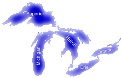
The Great Lakes contain the largest supply of freshwater in the world, holding about 18% of the world’s total freshwater and about 90% of the United States’ total freshwater. The Lakes provide drinking water to 40 million U.S. and Canadian citizens. Combined, the lakes cover an area of over 94,000 square miles (245,000 square kilometers) and contain 5,400 cubic miles (23,000 cubic kilometers) of water. The Great Lakes are a series of five interconnecting large lakes, one small lake, four connecting channels, and the St. Lawrence Seaway. The five large lakes are: Superior, Michigan, Huron, Erie, and Ontario. The small lake, located between Lake Huron and Lake Erie, is Lake St. Clair. Connecting these lakes together are the St. Marys, the St. Clair, The Detroit, and the Niagara Rivers. Average elevation in the Great Lakes ranges from 597 ft. (182 meters) on Lake Superior, to 242 ft. (74 meters) on Lake Ontario based on the International Great Lakes Datum of 1985 (IGLD85). The climate, soils, and topography in the Great Lakes region
vary due to the large size of the watershed. In the northern regions
the ground consists of granite bedrock beneath a thin layer of
acidic soils. The climate is much cooler than in the southern
regions, where the soils are thicker and contain mixtures of clays,
silts, sands, gravels, and boulders deposited by the glaciers
that formed the lakes. The southern region of the Great Lakes
watershed is dominated by agriculture due to its fertile soils. |
Last updated: 2004-06-02 jjs